
Temperature
Temperature variability | Frosts | El Nino Influence
| Average minimum temperatures for January and February are mostly below 9°C about the higher mountains and range from 12 to 15°C elsewhere. The highest overnight temperatures are recorded along the Murray River and near the Gippsland coast. Winter Winter temperatures do not show as much variation as the summer months. July is the coldest month with average maximum temperatures below 10°C over most of the Great Dividing Range and less than 3°C on the higher mountains. In winter the temperature variation from north to south is not as great as in summer. On the plains, average maximum temperatures range from 13°C near the coast to 16°C in the northern Mallee. On cold winter days, the maximum temperature may stay below 10°C on lowland areas and below 0°C on the Alps. Frosts The climatological definition of frost is the occurrence of an air temperature of less than 2.2°C, and a severe frost occurs when the air temperature decreases below 0°C. This definition is used because air temperature is measured at a height of about 1.3 metres above the ground. Overnight the ground temperature may be several degrees lower than the air temperature at thermometer height. |  Temperature maps on the Bureau of Meterology website(external link) Other Links Australian maps on the Bureau of Meteorology website showing mean annual and seasonal percentiles of minimum, maximum and mean temperature. (external link) | ||
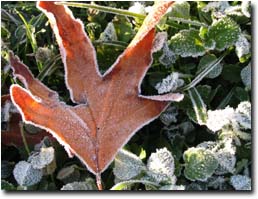 | The occurrence of frost as measured by a thermometer will not always coincide with the effects on certain plants. There are some important points to remember, however, about how frosts occur, and how the terrain can affect the incidence and severity of frost on a very local scale. Frosts are more common and severe in places into which cold air can drain during the night and in areas sheltered from the wind. A typical frost prone place is a valley bottom. Vegetation type and distribution, and the presence of water (e.g. lakes, drainage canals, etc.) also have a significant impact on frost frequency. Frosts are infrequent in coastal regions but occur frequently in most inland areas. The first frosts are often recorded in March or April and can occur as late as November. Along Victoria’s west coast, the frost-free season exceeds 250 days per year. In the north west of the state, the frost-free season is generally about 150 days, and in the highlands can be as short as 50 days. North of the Eastern and Western Uplands, frosts are generally twice as frequent as places on the southern side at similar altitudes, due to clearer skies at night. High altitude valleys in the north-east are quite prone to frost and fog. | The Bureau of Meteorology (external link) provides overview maps of Victoria’s mean monthly minimum and maximum temperatures. These maps are based on long term averages and developed using an analysis program which estimates climatic values between recording stations based on factors which influence rainfall and temperature (eg. altitude, topography). Related DPI Agnotes | |
El Nino Influence
Victorian climate conditions are also influenced by the ocean-atmosphere system in the tropical Pacific. The El Nino phenomenon is a disruption of this system which affects the normal climatic patterns in some years. Further Information on El Nino and La Nina can be found on the El Nino Theme Page (external link). (U.S. Department of Commerce/National Oceanic and Atmospheric Administration/ Tropical Atmosphere-Ocean Project)
Source :Climate of Victoria, Bureau of Meteorology (1993). Published by Australian Government Printing Services. Commonwealth of Australia. Copyright. Reproduced by permission.
Atlas of Victoria (1982).
© State of Victoria (Agriculture Victoria) 1996 - .

This work, Victorian Resources Online, is licensed under a Creative Commons Attribution 4.0 licence. You are free to re-use the work under that licence, on the condition that you credit the State of Victoria (Agriculture Victoria) as author, indicate if changes were made and comply with the other licence terms.
The licence does not apply to ‘branding’ or some ‘images or photographs’ that may be owned by third parties. We ask you to seek prior approval to use images using the VRO feedback form. Access to higher quality images can also be provided on request.
This page was last updated on .