Your gateway to a wide range of natural resources information and associated maps

Victorian Resources Online

Victoria's Salinity Provinces

What are Salinity Provinces?

Salinity Provinces (SPs) provide a framework for describing land and water (both surface and groundwater) salinity in Victoria. These are specific geographic areas where the landscape setting and physical processes contributing to salinity are similar, and where salinity management options are also similar. Each Province contains discrete salinity impacted areas where there is a concentration or higher incidence of land and/or water salinisation, which may or may not have been mapped. This may be "primary" or "secondary" salinity, the development of which can be explained by a particular landscape setting, groundwater process or most commonly, Groundwater Flow System(s) (GFS(s)).

The soil salinity mapping used to help delineate the SPs does not cover the Irrigation Regions of the State. In these areas, 'depth to watertable' and 'watertable salinity' mapping has been used to convey the threat of high watertables on soil waterlogging and/or soil salinisation. This information is yet to be included in the individual SP pages but links to existing maps have been added where appropriate.


History of the 'Salinity Provinces' concept

P. Macumber and C. Fitzpatrick of the former Department of Water Resources (Victoria) first introduced the concept of 'Salinity Provinces' in Victoria in a 1986 report. This report titled 'Salinity in Victoria: Physical Control Options' defined 14 'Salinity Provinces' distinguished by their distinctive hydrogeological and geomorphic characteristics. For each province, groundwater characteristics, salinity trends, control options and research and investigation needs were described.

In 2010, the Department of Primary Industries re-visited the 'Salinity Provinces' concept as a way of categorising salinity occurrence, risk and management options across Victoria. Out of this work was the delineation of the 140 'Salinity Provinces' described on these web pages.


Victoria's Catchment Management Authorities (CMAs)

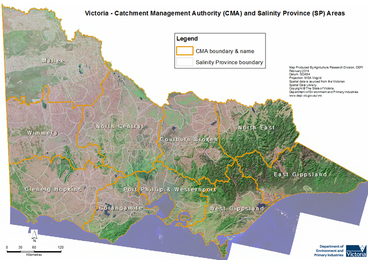
For the purpose of environmental asset management, Victoria has been divided into 10 major Catchment Management Regions (CMRs), each covering the area of one or more of the major surface catchments in the state. Catchment Management Authorities (CMAs) manage the environmental assets in each of these regions. The Salinity Provinces have been divided according to the CMA region in which they are located.


Salinity Province Locations and Details

Clicking within a CMA area on the map below will link to a page displaying a description of the CMA, including the general nature of the occurrence of salinity within that CMA, and it's Salinity Provinces. These pages also include a map of each CMA displaying the location of its Salinity Provinces and a table listing some of the details of each Province. Clicking within a particular Salinity Province on this CMA map will in turn link to a page providing salinity information, a map, and a table listing some other 'attributes' specific to that particular Salinity Province.

Victorian CMAs and Salinity Provinces Map

Click within a CMA to access more detailed information and a map of that CMA.


Glenelg Hopkins CMA Corangamite CMA Port Phillip & Westernport CMA West Gippsland East Gippsland CMA North East CMA North East CMA North Central CMA Wimmera CMA Mallee CMA

Why the SP boundaries are where they are?

The Province boundaries have been created around areas where salinity has been identified (but not necessarily mapped) and a range of defining characteristics linked to these occurrences (eg. the geomorphology, soil type(s), catchment(s), geology, and in particular, the Groundwater Flow System(s)) are similar. Each Province is also positioned such that (with two exceptions), they are fully located within one CMA Region only. As the nature of the characteristics used to define the location and extent of each province varies from one province to another, apart from the State boundary and the current borders of the State's CMA Regions, the specific province boundaries do not follow any particular existing natural (eg. rivers etc.) or artificial (eg. roads etc.) linear features (lines or edges).


Why the SPs were created or developed?

Land and water salinity is a hazard that exists in all major catchments throughout Victoria. The DEDJTR & DELWP have responsibility for both protecting the natural resource base and assisting the agricultural sector to improve productivity and protect environmental values.

Salinity Provinces provide a means to:

  • Aggregate salinity occurrences into discrete and manageable areas
  • Describe the defining features, likely causes of salinity and treatment options for saline sites
  • Identify requirements for ongoing monitoring and risk assessment
  • Provide a geographical basis for organising information about salinity across Victoria
Prioritisation

The Salinity Provinces have been given a priority ranking (High or Low) based upon a number of criteria. 'High' priority provinces:
  1. Include (or Intersect) the boundaries of: significant environmental or cultural assets, high value infrastructure (including urban development), and/or priority biodiversity areas.
  2. Contain significant salinity occurrences that pose a threat to land productivity, catchment health, downstream assets or water users, and/or high value infrastructure.
  3. Have reasonable prospects for successful salinity management interventions or treatment options that are considered feasible from both 'practicality' and 'return on investment' points of view.
Salinity Provinces that do not meet the above criteria are classified as 'Low' priority.

Salinity hazard can change from year to year or decade to decade in response to climatic variations, especially rainfall. Groundwater monitoring data allows the groundwater response to rainfall to be observed and this is then used to help define the changing salinity hazard in monitored Provinces. This assists communities and management agencies to review priorities as catchment conditions and strategies evolve over time.

Other details about their development and use

The key information and data provided for each SP in this first stage of the Salinity Province Web Pages is:
  1. A written 'introduction' to the salinity found in each Province, which provides a description of information relating to the occurrence of salinity within the province.
  2. A listing of the major 'attributes' and associated data, pertaining to each province.
  3. A detailed map showing the historical extent and location of recorded primary & secondary salinity from the dryland salinity database. Note: for provinces in irrigation area, a better indication of salinity threat is based on depth to watertable mapping. This is difficult to show on these maps as it varies from year to year, so links will be provided to any such available mapping.

Due to the technical complexities and costs of doing so, live or regularly updated monitoring data will not be provided for each Province; instead, links to existing monitoring site data on websites such as Visualising Victoria's Groundwater (VVG), will be provided.

Victorian CMAs Soil Salinity Details

Click on a CMA name in the table below to access more detailed information and a map of that CMA.

CMA NameTotal Area of CMA (ha)No. of Recorded Soil Salinity Units1Area Recorded as Saline (ha)1% of CMA Area Recorded as Saline1
Corangamite
1,334,660
1,212
16,744
1.25%
East Gippsland
2,081,644
43
922
0.04%
Glenelg Hopkins
2,673,080
3,285
27,841
1.04%
Goulburn Broken
2,407,072
726
4,670
0.19%
Mallee
3,930,675
1,138
128,223
3.26%
North Central
2,963,486
1,263
25,916
0.87%
North East
1,978,916
207
1,312
0.07%
Port Phillip & Westernport
1,278,376
499
2,587
0.20%
West Gippsland
1,715,844
264
16,774
0.98%
Wimmera
2,344,679
1,342,
22,163
0.95%
Statewide Total (T) or Average (A)
(T) 22,708,432
(T) 9,979
(T) 247,153
(A) 1.09%

1 Please Note: The 'No. of Recorded Soil Salinity Units', 'Area Recorded as Saline (ha)', and the '% of CMA Area Recorded as Saline' displayed in the table above comprises the 'total number', the 'total geographic area' and the 'percentage of the total area of the CMA' that have been mapped as having, or showing symptoms of, dryland soil salinity by DEDJTR (or its predecessors) at some time (past or present). As dryland soil salinity occurrence in the Victorian landscape exhibits many different levels of severity and can change due to climate, landuse and vegetation cover etc., previously mapped areas may no longer be showing symptoms of salinity and/or new areas may have occurred since the mapping was completed. In addition, as not all parts of the state have been mapped, or mapped in the same way, the mapping has not captured all occurrences.

For more information about salinity in your location, please contact the DEDJTR, DELWP, your Catchment Management Authority (CMA) or your rural water provider.


The 'Attributes' used to describe each individual Salinity Province

A number of 'attributes' have been selected to describe the basic details (its size etc.) and what is known about the salinity in each individual Salinity Province (SP). These attributes have been chosen such that together with each Province's 'Introduction' and map, most of the basic aspects of salinity within each Province can be provided or linked to, and thus made available for external use.

The attribute data for each Province can be accessed on their individual Salinity Province Page via their CMA page, which can be selected on the Victorian CMAs and Salinity Provinces Map or the Victorian CMAs Soil Salinity Details table on this page.


Individual Salinity Province Attribute Details

The table below provides some background information about the main attributes used to describe the salinity risks and occurrences in each Salinity Province. The values for these attributes are provided in the “Province Attributes” table on each individual Salinity Province page.

Attribute NameDescription of the AttributeClassifications Used and their DefinitionsPotential Salinity ImplicationsAttribute Notes
Priority StatusThe Priority Status of the Salinity ProvinceHigh or LowSee "Prioritisation" aboveThe criteria used to determine a Province's 'Priority Status'
Recorded Soil Salinity AreaThe area of mapped salinity in the Salinity ProvinceThe area in hectares (ha)Can indicate severity of the salinity problem in a Province or CMA and how it has changed over time.See here
Dominant Surface Geology TypeThe major "Surface Geology Type" within the Salinity Province areaIntrusive, Metamorphic or SedimentaryCan affect many of the physical conditions associated with salinity development.This attribute has been determined from the Statewide 1:250,000 scale (Digital) attributed Geological Map. Using the attribute: XXX. This attribute divides all surface rock types into these three categories only, with extrusives (predominantly Basalts) classified as “Sedimentary”.
Influence of Geological Structure on Salinity Occurrence/sThe likelihood or degree of Structural Influence or Control of salinity in the Salinity ProvinceNo Structural Influence (SI), Possible SI, Probable SI or
Definite SI
Geologic Structures can trap saline groundwaters forcing them towards the surface. Fault zones can increase hydraulic conductivity in fractured rock aquifers.This attribute has been determined from geological structural mapping and references on the effects of structural geology on salinity in various parts of the state.
Relevant Geomorphic Mapping Unit(s) (GMUs) The main Geomorphic Management Unit (GMU) class or classes found within the Salinity ProvinceThe existing DEDJTR GMU numbering classification systemKnowing the predominant Geomorphological setting can provide important information for understanding salinity occurrence within a province and therefore, the range of management options available for its control.Where a code contains an "X" in it, the "X" can be substituted with a variety of different numbers to create the different codes for the GMUs found in that Province. Definition of the codes used in this classification system
Predominant Groundwater Flow System (GFS)The main/dominant type of Groundwater Flow System(s) present in the Salinity Province.Local, Intermediate or Regional and combinations of these eg. Local/Intermediate.Can provide valuable information for understanding salinity causation and potential management optionsIn some Salinity Provinces, a number of Groundwater Flow Systems may exist at different levels below the surface, each of which can act independently or in combination to effect surface or near surface soil or water salinity.
Relevant Irrigation AreasThe name of any irrigation areas that part or all of a Salinity Province falls within.One or more Irrigation District namesThe drivers of salinity in irrigation areas can be quite different to those in dryland areas and different irrigation areas have different policies and regulations related to salinity.For Provinces completely outside of Irrigation Areas, this attribute is left blank.


Accessing the Salinity Provinces Maps and Spatial Data

The georeferenced dataset these attributes provide also allows each Province or group of Provinces (eg. all Provinces in a particular CMA or all Provinces bigger than a certain size), to be compared, contrasted or otherwise analysed (and/or displayed) within a GIS system. To allow this to occur, as well as being displayed on these web pages, this spatial dataset is also freely available through the DataVic website by following the link below or by contacting the Salinity Provinces website developers (for details, see the base of this page).

The link to the Salinity Province spatial dataset at the DataVic website is here.


Glossary of Salinity Related Terms

AHD: Australian Height Datum.

Alluvium: Alluvium is loose, unconsolidated (not cemented together into a solid rock) soil or sediments, which has been eroded, reshaped by water in some form, and redeposited in a non-marine setting. Alluvium is typically made up of a variety of materials, including fine particles of silt and clay and larger particles of sand and gravel.

Aquifer: An aquifer is a sequence of saturated fractured rock and/or sediment from which usable volumes of groundwater can be pumped.

Break-of-Slope: A sudden change in the topographic gradient of the lands surface eg. the position in the landscape where steeper hills become flatter plains. It is in these situations where the discharge of saline groundwaters can occur.

Colluvium: Colluvium is a general name for loose, unconsolidated sediments that have been deposited at the base of hill slopes by either rain-wash, sheet-wash, slow continuous downslope creep, or a variable combination of these processes. Colluvium can be composed of a heterogeneous range of sediments ranging from silt to rock fragments of various sizes

Cyclic Salts: Salts (predominantly Sodium Chloride) carried inland as wind-driven sea spray and precipitated with rainfall.

Deep Lead: A term derived from the gold mining era used to describe old river sediments covered by younger geological deposits, usually basalt.

Discharge: Discharge is the process whereby groundwater leaves (flows from) an aquifer or specific groundwater layer (usually at or near the earth's surface).

Fractured Rock Aquifer: A fractured rock aquifers is an aquifer where the water is stored in, and flows through, a series of interconnecting cracks (or fractures) in a rock unit.

Groundwater: Groundwater is the water found beneath the earth's surface in pores and fractures of soil and rocks.

Groundwater Flow System: A Groundwater Flow System (GFS) is the three dimensional geographic space where groundwater flows from a recharge to a discharge area (ie. an aquifer or set of aquifers) and where the processes leading to salinity are similar. They are differentiated by their scale, that being, the distance from the recharge to discharge area; as either Local (<5 km), Intermediate (5 - 50 km) or Regional (>50 km) GFSs. Groundwater residence times may vary from days to tens of thousands of years depending on the scale of the GFS.

Hydraulic Conductivity: The hydraulic conductivity of an aquifer is a measure of the ease with which water can move through it.

Living-with-Salt: Recognising that increasing amounts of salt and shallow groundwater are inevitable or natural features (Primary Salinity) in some locations, and hence there is a need to adapt to this (more) saline environment. 'Living with salt' therefore describes a range of agricultural practices that accommodate salinity, and in some areas, innovative approaches that may turn the salinity 'problem' into an economic 'opportunity'.

Paludal: Sediments deposited in marshes, usually sands, silts and clays mixed with organic material.

Primary Salinity: Naturally occurring salinity ie. salinity that is unrelated to human activity and was usually present prior to European settlement in an area.

RCS: Regional Catchment Strategy.

Recharge: Recharge is the process whereby an aquifer or specific groundwater layer is replenished by water draining (or being 'pushed') into the groundwater system.

Secondary Salinity: Salinity that is induced or increased by human activity eg. due to the removal of trees or deep-rooted native pasture. Primary Salinity can become Secondary Salinity because of human activity.

Tillite: A sedimentary rock that consists of consolidated masses of unweathered blocks (large, angular, detached rock bodies) and glacial till (unsorted and unstratified rock material deposited by glacial ice) in a matrix or paste of unweathered rock. Tillites are formed from material eroded by, and deposited from, the action of a glacier.

Watertable: The watertable is the surface between the saturated and unsaturated zones in a soil or regolith profile. It is also the top of an unconfined aquifer.


Acronyms

BOS Break-Of-Slope
CMA Catchment Management Authority
CMR Catchment Management Region
DEDJTR Department of Economic Development, Jobs, Transport and Resources
DELWP Department of Environment, Land, Water and Planning
GFS Groundwater Flow System
GMU Geomorphic Management Unit
SIR Shepparton Irrigation Region
SP Salinity Province
VRO Victorian Resources Online
VVG Visualising Victoria's Groundwater


Links to further reading

Main VRO Salinity Page


Contact Details of Project Developers:

Project Designer/Principle Writer & Editor
Alister Terry
DEDJTR Tatura Centre
alister.terry@ecodev.vic.gov.au

Project Supervisor/Manager
Bruce Gill
DEDJTR Tatura Centre
bruce.gill@ecodev.vic.gov.au
Page top