
Long term comparison of rotation and fallow management practices in the Victorian Mallee (MC14) - Walpeup
|
The MC14 experiment was established in 1985 to compare the long term effects of rotation and fallow management on wheat production in the Mallee. | 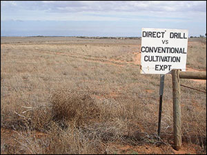 MC14 sign at Walpeup - the sign reads 'Direct drill vs conventional cultivation expt.' (experiment) |
Landscape visualisation
To take a better look at the MC14 research site, use your keyboard and mouse to navigate the MC14 experimental area. To zoom in or out, left mouse click inside the panorama and use the mouse's 'scroll wheel' (if you have one) or press and hold 'Shift' or 'Ctrl'. To explore the landscape, click and hold the left mouse button on the landscape and move the mouse left, right, up or down or use 'cursor keys'.
This virtual landscape uses 'Flash'. Please update to the latest version of the 'Adobe Flash Player'.

We've detected that the 'Adobe Flash Player' installed is either missing or not fully up-to-date and cannot play the content we've created.
For the best viewing experience please click on the icon above to install the latest version of the Adobe Flash Player.
Icons used in landscape visualisation
Panorama | Photograph |
NOTE: To leave panorama press 'Ctrl' and 'F5'.
Click on icons appearing in the landscape for access to photographs, further information and other panoramas in this experimental area.
If you experience any problems with the interactive panorama click outside the landscape and press 'Ctrl' and 'F5'.
Each interactive landscapes is 2 MB, this might take some time to automatically download if you're using a slow internet connection. If you experience any problems you should update the 'Adobe Flash Player'. This software can be downloaded for free from the Adobe website (external link).
Outputs
This site has provided measurement of yield of wheat in response to rotation and conservation tillage practice compared with conventional practice. This site was also used to assess the impact of management on root disease such as rhizoctonia root rot (Rhizoctonia soloni) and take-all (Gaeumannomyces graminis var. tritici). The MC14 site is also used regularly as a resource for postgraduate students and agricultural researchers within collaborative projects, where it provides a known history of management and rotation treatment. Scientific publications arising from this site are listed below.
Experimental Design
Since 1985, a total of 42 plots are sown each year on the MC14 site at Walpeup. Three replicates of each phase of each rotation are sown on plots 4.2 metres by 40 metres in size (refer figure below). Rotations included:
- pasture - fallow - cereal
- fallow - cereal
- pasture - cereal
The wheat (cv. Yipti) is sown both using direct drill and conventional techniques.
Modifications to the original design are restricted to variation in length of the short fallow, although this does not compromise the overall integrity of the site.
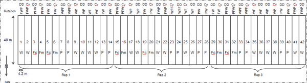
| W = Wheat | Fm = Mechanical fallow | DD = direct drill, sow wheat with narrow points and press wheels |
| P = Medic pasture | Fc = Chemical fallow | Cv = Conventionally sown wheat with standard points and harrows |
Figure 1. Field lay out and site design of the MC14, Walpeup, Victoria. Example is for crops sown in 2010.
From 1985 to the present, regular sampling and analyses of various soil and plant properties has occurred annually. This includes grain yield and quality, emergence counts, biomass at anthesis and maturity, soil moisture at sowing and maturity (neutron probe) and sowing mineral-nitrogen. Soil pathology was collected from 1985 to 2006, and soil chloride was measured in 1990.
Related Publications
Bissett MJ and O’Leary GJ (1996) Effects of conservation tillage and rotation on water infiltration in two soils in south-eastern Australia. Australian Journal of Soil Research 34, 299-308. http://www.publish.csiro.au/nid/84/paper/SR9960299.htm (external link)
Incerti M, Sale PWG and O’Leary GJ (1993a) Cropping practices in the Victorian Mallee 1. Effect of direct drilling and stubble retention on the water economy and yield of wheat. Australian Journal of Experimental Agriculture 33, 877-883. http://www.publish.csiro.au/paper/EA9930877.htm (external link)
Incerti M, Sale PWG and O’Leary GJ (1993b) Cropping practices in the Victorian Mallee 2. Effect of long fallows on the water economy and the yield of wheat. Australian Journal of Experimental Agriculture 33, 885-894. http://www.publish.csiro.au/paper/EA9930885.htm (external link)
O’Connell MG, O’Leary GJ and Incerti M (1995) Potential groundwater recharge from fallowing in north-west Victoria, Australia. Agricultural Water Management 29, 37-52.
O’Leary GJ and Incerti M (1995) A field comparison of three neutron moisture meters. Australian Journal of Experimental Agriculture 35, 59-69.
© State of Victoria (Agriculture Victoria) 1996 - .

This work, Victorian Resources Online, is licensed under a Creative Commons Attribution 4.0 licence. You are free to re-use the work under that licence, on the condition that you credit the State of Victoria (Agriculture Victoria) as author, indicate if changes were made and comply with the other licence terms.
The licence does not apply to ‘branding’ or some ‘images or photographs’ that may be owned by third parties. We ask you to seek prior approval to use images using the VRO feedback form. Access to higher quality images can also be provided on request.
This page was last updated on .