
W5 Werribee South - Werribee River Delta Sediments
|
This information has been developed from the publications:
|
| Location Access Ownership | Werribee - 000970. Shire of Werribee. Coastal sector extending 200 m south of Cunninghams Road, Werribee South. Cunninghams Road. Crown land. | 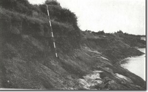 W5 - Silt and sands of the Werribee delta, Werribee South. |
Site Description | The coastal cliffs are earth cliffs cut into the sediments of the Werribee River Delta. This formation is a very distinctive delta-shaped sedimentary body, with the apex located several kilometres upstream from the Werribee and the distal ends located on the coastline extending from south of Point Cook to the mouth of Little River. | |
| It is not a true sub-aqueous delta as it consists dominantly of red brown clay loam without obvious bedding and lacks marine fossils. It is most likely to have originated as a floodplain crossed by distributary streams, traces of which can be seen at other localities. At Cunninghams Road, the cliffs are 4 to 5 m high, but the lower 2 m are still well exposed, and the prismatic structure of the clay loam soils and a thin overlying sand bed can be clearly seen. | ||
Significance | Regional. The site is a clear exposure of this important and unusual sedimentary body. As most of the area of the delta is utilised for intensive farming, this is one of the few places where a section of the upper parts of the formation may be examined with easy road access. | |
Management | Class 2. There should be no future reclamation of the upper part of the cliff exposure at the site. Extension of boating or fishing facilities that involve structures that obscured the cliff face should not be permitted. | |
References | Condon, M.A. (1951). The Geology of The Lower Werribee River, Victoria. Proc. R. Soc. Vict. 63:1-24. | |

© State of Victoria (Agriculture Victoria) 1996 - .

This work, Victorian Resources Online, is licensed under a Creative Commons Attribution 4.0 licence. You are free to re-use the work under that licence, on the condition that you credit the State of Victoria (Agriculture Victoria) as author, indicate if changes were made and comply with the other licence terms.
The licence does not apply to ‘branding’ or some ‘images or photographs’ that may be owned by third parties. We ask you to seek prior approval to use images using the VRO feedback form. Access to higher quality images can also be provided on request.
This page was last updated on .