
W4 Werribee - Werribee River Delta Sediments
|
This information has been developed from the publications:
|
| Location | Werribee - 953983. Former Shire of Werribee. River cliffs of the Werribee River extending from the golf club south for one kilometre. | 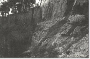 W4 - Gravels, sands and silts of Werribee delta near Werribee golf course. |
Access | K Road. | |
Ownership | Crown land | |
Site Description | Almost vertical cliffs, up to 10 m high flanking the eastern side of the Werribee River, expose an excellent section of the floodplain sediments of the Werribee River Delta. This formation is a very distinctive delta-shaped sedimentary body, with the apex located several kilometres upstream from Werribee and the distal ends located on the coastline extending from south of Point Cook to the mouth of Little River. | |
It is not a true sub-aqueous delta as it consists dominantly of a red brown clay loam without obvious bedding and lacks marine fossils. It is most likely to have originated as a floodplain crossed by distributary streams, traces of which can be seen at other localities. At river level south of the golf clubhouse, the deposit consists of 2 m of well rounded quartz and sandstone coarse gravels overlain by 1 to 2 m of bedded sands. The rest of the section above this is a cohesive silty clay loam typical of the bulk of the materials elsewhere in the delta. | ||
West of the river, the lower lying terrain is the modern floodplain sediments of the Werribee including a reed-covered alluvial island in the river channel. | ||
Significance | State. This site is the best natural section of the thick alluvial deposits that characterise the agricultural area southeast of Werribee. It is an outstanding record of the Late Quaternary history of the Werribee River. The meandering course and the alluvial island add to the interest of the site. | |
Management | Class 1. If it is considered that engineering works are necessary to reduce the hazard river erosion may pose to K Road, the works should attempt to maintain the integrity of the steepest sections near the golf clubhouse. It would be preferable to divert the river course, by shortening the meander, rather than regrading or walling the river banks. The unmade public road south of K Road along the river bank is an unnecessary risk, and should either be closed or relocated away from the cliff edge and improved. Dredging or other interference with the channel island should not be permitted. | |
References | Condon, M.A. (1951). The Geology of The Lower Werribee River, Victoria. Proc. R. Soc. Vict. 63:1-24. | |

© State of Victoria (Agriculture Victoria) 1996 - .

This work, Victorian Resources Online, is licensed under a Creative Commons Attribution 4.0 licence. You are free to re-use the work under that licence, on the condition that you credit the State of Victoria (Agriculture Victoria) as author, indicate if changes were made and comply with the other licence terms.
The licence does not apply to ‘branding’ or some ‘images or photographs’ that may be owned by third parties. We ask you to seek prior approval to use images using the VRO feedback form. Access to higher quality images can also be provided on request.
This page was last updated on .