
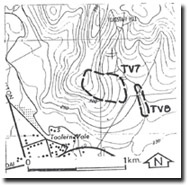
TV7 Flagstaff Hill - Gully and Tunnel Reclamation
|
This information has been developed from the publications:
|
| Location Access Ownership | Toolern Vale - 880353. Shire of Melton. Eastern slopes of Flagstaff Hill 1 km northeast of Toolern Vale. From Diggers Rest to Coimadai Road. Private land. |
Site Description | On the steep slopes of Flagstaff Hill, weathered Palaeozoic sediments have developed a clay-rich soil. Clearing and intensive grazing (stock and rabbits) have contributed to severe tunnel and gully erosion being maintained, with long parallel gullies and downslope sequences of tunnels and tunnel mouth fans evident. Improved land management and physical reclamation has reclaimed much of the deteriorating land surfaces although some smaller gullies persist and tunnel development is still active. |
Significance | Regional. The site demonstrates the fragile equilibrium of slopes developed on the Ordovician shales and mudstones. |
Management | Class 3. Continued appropriate stocking ratios, revegetation and rabbit control are required at the site. |
TV8

© State of Victoria (Agriculture Victoria) 1996 - .

This work, Victorian Resources Online, is licensed under a Creative Commons Attribution 4.0 licence. You are free to re-use the work under that licence, on the condition that you credit the State of Victoria (Agriculture Victoria) as author, indicate if changes were made and comply with the other licence terms.
The licence does not apply to ‘branding’ or some ‘images or photographs’ that may be owned by third parties. We ask you to seek prior approval to use images using the VRO feedback form. Access to higher quality images can also be provided on request.
This page was last updated on .