
SW4 Deans Marsh, Rockbank - Intermittent Lakes
|
This information has been developed from the publications:
|
| Location | Sydenham West - 948215. Shire of Melton. North of Western Highway at Rockbank. | 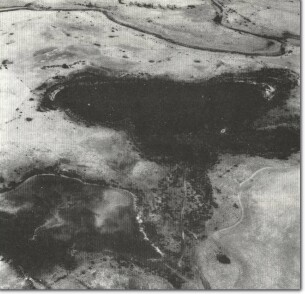 SW4 - Intermittent Lakes, Deans Marsh, Rockbank |
Access | Western Highway. | |
Ownership | Commonwealth land (Defence Department, Rockbank Signal Station) and private land. | |
Site Description | Between Kororoit Creek and the Western Highway are several enclosed depressions on the surface of the lava plain. The depressions appear to be due to the original configuration of the contours of the lava and are an integral part of the original basalt terrain. | |
The two westernmost depressions, that comprise this site, are generally marshy, indicating they are fed from groundwater springs; they are intermittent rather than ephemeral lakes. The lake water is slightly brackish and alkaline, and there is a concentration of the sulphate ion. There is no surface water exchange between the lakes but the northern lake is partly artificially drained to Kororoit Creek. It is likely that there is a complex hydrological regime of these lakes related to water levels of Kororoit Creek. | ||
Significance | Regional. Although there are many enclosed depressions on the Werribee Plains, most have been severely disturbed by draining, grazing, reclamation or other processes. The two wetlands at this site are therefore important remnants to illustrate the formerly complex drainage and surface water distribution of the plains. They should be retained to allow studies of water quality and hydrological regime. The shorelines of the lakes are low and rocky and illustrate the weathering of basalt boulders in a saline wetting and drying environment. | |
Management | Class 1. The lakes need to be excluded from disturbance associated with adjacent land use. As most of the surrounding area is being subdivided, it is important that planning controls prevent the draining, filling, or reclamation of these two remaining wetlands, and ensure that street drainage or other urban runoff is not diverted into them. The drain from the northern lake should be closed. The lakes should be seen as a positive factor providing important terrain variation in an otherwise uniform landscape. | |
References | Shugg, A. (1980). Disturbed Drainage and an Ephemeral Lake on the Basalt Plains, Rockbank (Kororoit Creek). Unpub. Reports Geol. Survey Vic. 108. | |

© State of Victoria (Agriculture Victoria) 1996 - .

This work, Victorian Resources Online, is licensed under a Creative Commons Attribution 4.0 licence. You are free to re-use the work under that licence, on the condition that you credit the State of Victoria (Agriculture Victoria) as author, indicate if changes were made and comply with the other licence terms.
The licence does not apply to ‘branding’ or some ‘images or photographs’ that may be owned by third parties. We ask you to seek prior approval to use images using the VRO feedback form. Access to higher quality images can also be provided on request.
This page was last updated on .