
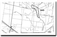
SW3 Rockbank - Kororoit Creek Floodplain
|
This information has been developed from the publications:
|
| Location | Sydenham West - 950235. Shire of Melton. Valley of Kororoit Creek 2 km northeast of Rockbank. | 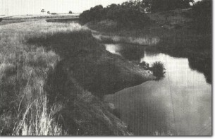 SW3 - Alluvial floodplain sector of Kororoit Creek, Rockbank. |
Access | Beattys Road. | |
Ownership | Crown land and private land. | |
Site Description | The valley of Kororoit Creek upstream of Beattys Road bridge is a wide floodplain with abandoned stream channels. Below the bridge, the valley narrows and is incised into enclosing lava flows. A small quarry exposes a section in basalt lava flows showing strong platey jointing. | |
Significance | Regional. The site illustrates the influence of lava flows on drainage patterns and show the hydrological complexity of the Kororoit Creek. | |
Management | Class 2. The stream channels in the site should not be artificially modified. The area should be reserved from intensive residential subdivision and retained for open space use. | |
 SW3
SW3

© State of Victoria (Agriculture Victoria) 1996 - .

This work, Victorian Resources Online, is licensed under a Creative Commons Attribution 4.0 licence. You are free to re-use the work under that licence, on the condition that you credit the State of Victoria (Agriculture Victoria) as author, indicate if changes were made and comply with the other licence terms.
The licence does not apply to ‘branding’ or some ‘images or photographs’ that may be owned by third parties. We ask you to seek prior approval to use images using the VRO feedback form. Access to higher quality images can also be provided on request.
This page was last updated on .