
Sb4 Mount Aitken - Eruption Point
|
This information has been developed from the publications:
|
| Location | Sunbury - 917418. Former Shire of Gisborne. South of the Calder Highway 7 km southeast of Gisborne. | 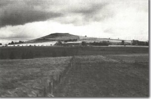 Sb4 - The distinctive flat top and asymmetrical profile of Mount Aitken, Gisborne. |
Access | Calder Highway | |
Ownership | Private land | |
Site Description | Mount Aitken (500 m) is one of the most prominent of the eroded volcanic hills between Sunbury and Gisborne. The form of the hill is similar to Red Rock and Mount Holden, having a more or less flattened top, rocky cliffs and ridges around the summit, and one long gentle slope down to the level of the surrounding plain. The outcrops are the last of the lava flows from the summit area of the volcano, the vent becoming infilled with this solidified lava and surrounded by a rim of scoria. Erosion has since removed the scoria, levelled the summit and obscured the vent of the volcano. | |
Significance | Local. This eruption point forms a part of the major volcanic sequence that produced the plains topography between Sunbury and Gisborne. | |
Management | Class 2. To retain the significant form of the hill, no further building construction should be permitted above the 440 m contour. | |
Related sites on VRO
- Eruption Points of the Newer Volcanics (Rosengren 1994) - Mount Aitken

© State of Victoria (Agriculture Victoria) 1996 - .

This work, Victorian Resources Online, is licensed under a Creative Commons Attribution 4.0 licence. You are free to re-use the work under that licence, on the condition that you credit the State of Victoria (Agriculture Victoria) as author, indicate if changes were made and comply with the other licence terms.
The licence does not apply to ‘branding’ or some ‘images or photographs’ that may be owned by third parties. We ask you to seek prior approval to use images using the VRO feedback form. Access to higher quality images can also be provided on request.
This page was last updated on .