
Sb3 Fitzgerald Hill
|
This information has been developed from the publications:
|
| Location | Sunbury - 947417. Shire of Bulla. East of Murray Road 8 km northwest of Sunbury. | 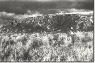 Sb3 - Eroded edge of lava flow from Fitzgerald Hill. |
Access | Murray Road off Sunbury to Gisborne Road. | |
Ownership | Private land. | |
Site Description | Fitzgerald Hill is a very rocky eruption point with three levels of parallel rocky ridges on the eastern side of the hill. The highest outcrops are up to 5 m high. These ridges and terraces of lava illustrate the stages of growth of the volcano. On the western side there is a long gentle slope flanked by low rocky cliffs descending to the level of the plain. This slope is the last lava flow which filled the vent. Erosion of scoria from the summit and slopes has further obscured the original vent. | |
Significance | Regional. The hill is a very clear example of the processes of volcanism and subsequent erosion in the Sunbury - Gisborne area. As with other eruption points in this area eg - Mt Holden, Mt Aitken, Deverall Hill, Red Rock, this hill imparts a very distinctive character to the landscape between Sunbury and Gisborne and is a very strong expression of the original of the geology and geomorphology of the area. If unrestricted building activity is permitted to interrupt the contour and the very distinctive profile of these hills, the significance of volcanicity as the major landform process here will be seriously diminished. | |
Management | Class 1. The site should be kept in rural land use or reserved for use in a public open space system. Buildings should not be permitted above the 330 m contour as this would detract from the significant form of the volcano. Along with other volcanic hills, walking and horse riding activities would be appropriate to maintaining the significance of the site. |

© State of Victoria (Agriculture Victoria) 1996 - .

This work, Victorian Resources Online, is licensed under a Creative Commons Attribution 4.0 licence. You are free to re-use the work under that licence, on the condition that you credit the State of Victoria (Agriculture Victoria) as author, indicate if changes were made and comply with the other licence terms.
The licence does not apply to ‘branding’ or some ‘images or photographs’ that may be owned by third parties. We ask you to seek prior approval to use images using the VRO feedback form. Access to higher quality images can also be provided on request.
This page was last updated on .