
S3 Altona East - Sand Bars
|
This information has been developed from the publications:
|
| Location | Sunshine - 120073. Former City of Altona. Offshore area extending for 600 m south and 1 km west from the Mouth of Kororoit Creek. | 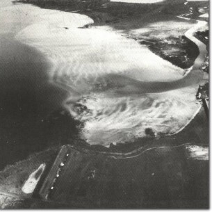 S3 - Sand Bars, Altona East. |
Access | Altona Road and Altona Sports Park. | |
Ownership | Crown land | |
Site Description | The site includes the intertidal and submarine topography of part of northern Port Phillip Bay. The coastline is sandy with occasional basalt boulders, while offshore is a 500 m wide belt of sand bars that lie roughly parallel to the coastline. | |
The bars are of low amplitude (20 to 40 cm) have broad flattened crests and are spaced from 15 to 30 m apart. There are about 20 bars in the entire sequence, the outer bars being the most parallel and regular with some individual bars extending unbroken for 400 to 600 m. The outer edge of the bar system terminates abruptly with the sandy bars resting on submerged basalt. There appears to be little or no sand accumulating beyond this edge. | ||
Significance | Regional. This system forms a major component of the complex of sandy onshore and offshore accumulation features along the western coastline of Port Phillip Bay. All the sand appears to have been derived by northward drift along the western coastline of Port Phillip Bay. This bar system is unusual in the context of the Bay as it is a thin veneer of sand lying on a rocky substrate with an abrupt outer margin. Because of the much gentler offshore gradient, the intertidal sand flats exposed at low tide here are much wider than those on the northeastern side of the Bay. | |
Management | Class 2. To maintain the integrity of the system, it is necessary to minimize interruptions to the movement of sand by natural tidal, wind and current processes. Dredge spoil should not be deposited on any part of the system, but should not be deposited on any part of the system, but should be directed to areas east of the mouth of Kororoit Creek. Boating facilities or other artificial structures that would therefore with the movement of sand should not be permitted. | |

© State of Victoria (Agriculture Victoria) 1996 - .

This work, Victorian Resources Online, is licensed under a Creative Commons Attribution 4.0 licence. You are free to re-use the work under that licence, on the condition that you credit the State of Victoria (Agriculture Victoria) as author, indicate if changes were made and comply with the other licence terms.
The licence does not apply to ‘branding’ or some ‘images or photographs’ that may be owned by third parties. We ask you to seek prior approval to use images using the VRO feedback form. Access to higher quality images can also be provided on request.
This page was last updated on .