
M4 Essendon West - Tertiary Sediments
|
This information has been developed from the publications:
|
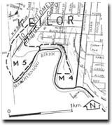
| Location | Maribyrnong - 135189 to 137185. Former City of Keilor. Northern and eastern banks of Maribyrnong River south of Buckley Street, Essendon West. | 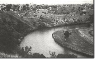 M4 - Red Bluff Sand (arrowed) outcropping above Maribyrnong River, Essendon West. |
| Access | Prospect Street. | |
| Ownership | Crown Land | |
Site Description | The river cliff exposes cross bedded pale yellow to red sands and clays of the Red Bluff Sand resting on weathered basalt of the Older Volcanics. The Red Bluff Sand is well exposed in small abandoned quarries and the Older Basalt crops out at river level. | |
Significance | Regional. The site is a clear exposure of some of the Tertiary formations below the Newer Volcanics basalt. Few similar exposures occur in the study area. | |
Management | Class 2. No filling or reclamation work that would obscure the geological sections should be undertaken at the site |

© State of Victoria (Agriculture Victoria) 1996 - .

This work, Victorian Resources Online, is licensed under a Creative Commons Attribution 4.0 licence. You are free to re-use the work under that licence, on the condition that you credit the State of Victoria (Agriculture Victoria) as author, indicate if changes were made and comply with the other licence terms.
The licence does not apply to ‘branding’ or some ‘images or photographs’ that may be owned by third parties. We ask you to seek prior approval to use images using the VRO feedback form. Access to higher quality images can also be provided on request.
This page was last updated on .