
M1 Williamstown - Lava Blister
|
This information has been developed from the publications:
|
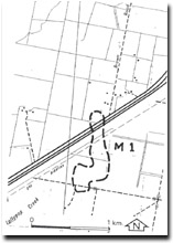
| Location | Maribyrnong - 158063; former City of Williamstown. Back of the beach, approximately 150 m east of Williamstown Cricket Ground. | 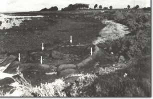 M1 - Lava blister, Williamstown. (Arrows show truncated rim.) |
Access | Unnamed road off Morris Street in front of Fort Gellibrand. | |
Ownership | Crown land. | |
Site Description | At the rear of the shore platform is a raised, kidney-shaped basalt structure that has been interpreted as a lava blister. Lava blisters develop when fluid lava crosses a shallow body of standing water or swamp ground, causing the water to boil, and the confined steam pressure is sufficient to raise the surface of the lava into a closed domal form. The structure at Williamstown is a shallow elliptical open bowl, measuring 4.8 m by 3.4 m with a rim 30 to 40 cm deep. If it is a truce lava blister, the upper part of the dome has been removed by weathering and erosion. | |
Significance | State. While there are many types of raised and uneven surfaces on lava flows, truce lava blisters are unusual in the volcanic rocks of Victoria. As the structure is now seldom over washed by waves, the truncation of the upper surface of the blister could be due to wave action at slightly higher sea level. | |
Management | Class 1. The structure is vulnerable to damage during activities such as road maintenance, coastal protection works and development of recreation facilities as it is only a few metres from the edge of the road. The management authority should be made aware of the significance and vulnerability of this feature as a matter of urgency. It is desirable to set back the road several metres at this point to provide protection for the site or to provide alternative traffic movement around the Gellibrand Fort. No coastal installations or sea defence works should be undertaken here that would cause damage to, or would obscure, the blister. | |
References | Hills, E.S. (1940). The Question of Recent Emergence of the Shore of Port Phillip Bay. Proc. R. Soc. Vict. 54:79-92. Juston, J.T. (1931). Erosion and Sedimentation in Port Phillip Bay, Victoria. Proc. R. Soc. Vict. 43:164-174. | |

© State of Victoria (Agriculture Victoria) 1996 - .

This work, Victorian Resources Online, is licensed under a Creative Commons Attribution 4.0 licence. You are free to re-use the work under that licence, on the condition that you credit the State of Victoria (Agriculture Victoria) as author, indicate if changes were made and comply with the other licence terms.
The licence does not apply to ‘branding’ or some ‘images or photographs’ that may be owned by third parties. We ask you to seek prior approval to use images using the VRO feedback form. Access to higher quality images can also be provided on request.
This page was last updated on .