
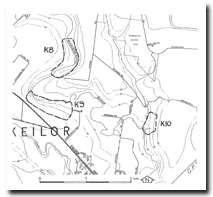
K10 Keilor - Dry Creek/Maribyrnong River Confluence
|
This information has been developed from the publications:
|
Location Access Ownership | Keilor - 096246. Former City of Keilor. Valley of Dry Creek extending 300 m upstream from the confluence of the Maribyrnong River. Annandale Road. Private land and some Crown land | 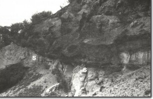 K10 - Unconformity between Silurian sediments (S) and Red Buff Sand, Maribyrnong River/Dry Creek, Keilor. |
Site Description | Geological sections exposed along the stream banks and in quarries, show a sequence (from bottom up) through Silurian sediments, cemented sub-basaltic sediments, Older Volcanics, Tertiary sediments and Newer Volcanics. The valleys of the streams have been partly infilled with alluvial terraces and these are particularly well developed in the Keilor area. | |
The terraces have yielded important archaeological material and have been investigated and mapped in considerable detail. A number of radiocarbon dates of materials contained in the terraces has been published. The archaeological significance of these sites has not been evaluated in this report. | ||
Significance: | Regional. The site provides an excellent display of the geological materials of the Maribyrnong River valley. There is a particularly good exposure of the unconformity at the top of Silurian sediments. | |
Management: | Class 2. The geological sections that are stable (not in danger of collapse or slumping) should be retained. Advice on conservation of significant archaeological features at the site should be obtained. | |
References: | Keble, R.A. and McPherson, J.H. (1946). Bowler, J.M. (1970). Alluvial Terraces in the Maribyrnong Valley, near Keilor, Victoria. Memoirs. Nat. Mus. Vic. 30:15-59. Joyce, E.B. and Anderson, J.R. (1976). | |
K10

© State of Victoria (Agriculture Victoria) 1996 - .

This work, Victorian Resources Online, is licensed under a Creative Commons Attribution 4.0 licence. You are free to re-use the work under that licence, on the condition that you credit the State of Victoria (Agriculture Victoria) as author, indicate if changes were made and comply with the other licence terms.
The licence does not apply to ‘branding’ or some ‘images or photographs’ that may be owned by third parties. We ask you to seek prior approval to use images using the VRO feedback form. Access to higher quality images can also be provided on request.
This page was last updated on .