
E1 Werribee River, Exford Bridge to Staughton Bridge - Gorge
|
This information has been developed from the publications:
|
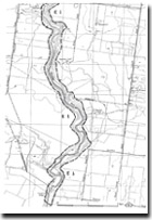
| Location | Eyensbury - 867125 to 865185. Former Shire of Werribee. Werribee River Valley north of Cobbledicks Ford. | 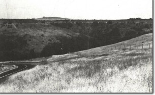 E1- Deeply incised valley of Werribee River between Melton Reservoir and Cobbledicks Ford. |
Access | Dohertys Road, Dukelows Road, Cobbledicks Ford Road. | |
Ownership | Private land. | |
Site Description | Between Exford Bridge and Cobbledicks Ford the Werribee River has incised a steep-sided gorge into the gently undulating lava plains of the Exford Volcanics. These lavas are alternating flows of olivine basalt and augite basalt with occasional beds of scoria and tuff, and are well exposed at several places along the river gorge. | |
The thickest flows (10 to 15 m) are of hard dense basalt and the pyroclastics usually 1 to 3 m. Near the rim of the gorge is a distinctive ropy and scoriaceous flow resting on a scoria deposit 1 m thick. The thicker flows are roughly columnar jointed and there is strong development of closely spaced platy jointing. This close fracturing system accounts for the high permeability of the lavas and the dryness of the lava surface. | ||
An alluvial deposit up to 20 m thick has accumulated in the gorge of the Werribee River. Gravely at the base, this material fumes upwards an at the surface is clayey. The present river channel is incised at the bottom of the gorge into this older alluvium and the incised trench has been partly refilled by a terrace of newer alluvium. | ||
Significance | Regional. The gorge is the major terrain feature of the Werribee Plains and provides the only natural sections into the Exford Volcanics. The valley walls show sufficient outcrop to clearly indicate the complexity of these erupted materials. The alluvial terraces on the valley floor provide evidence of Pleistocene and Holocene sea level changes. | |
Management | Class 2. Because of the extent of private property, the valley floor is not publicly accessible between Exford Bridge and Cobbledicks Ford. In the event of property subdivision, it is desirable that public access corridors be provided to several parts of the gorge in that sector and walking paths be provided to allow access along the valley. The outcrops of geological significance are robust and can tolerate visitor pressure for a range of activities. | |
References | Condon, M.A. (1951). The Geology of The Lower Werribee River, Victoria. Proc. R. Soc. Vict. 63:1-24. | |
E1

© State of Victoria (Agriculture Victoria) 1996 - .

This work, Victorian Resources Online, is licensed under a Creative Commons Attribution 4.0 licence. You are free to re-use the work under that licence, on the condition that you credit the State of Victoria (Agriculture Victoria) as author, indicate if changes were made and comply with the other licence terms.
The licence does not apply to ‘branding’ or some ‘images or photographs’ that may be owned by third parties. We ask you to seek prior approval to use images using the VRO feedback form. Access to higher quality images can also be provided on request.
This page was last updated on .