
AB4 Point Cook - Parallel Sand Ridges
|
This information has been developed from the publications:
|
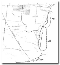
| Location | Altona Bay - 060000. Former Shire of Werribee. Coastal area extending two kilometres southwest of Point Cook Homestead. | 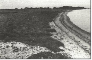 AB4 - Coastal sand ridges Point Cook. |
Access | Point Cook Homestead Road. | |
Ownership | Crown land. | |
Site Description | Southwest from Point cook is a zone of sand ridges 250 m wide that completely encloses a former embayment or depression in the basalt of the Newer Volcanics. | |
The ridge crests are broad, parallel, evenly spaced, average 2 m in height, and at their inner margin are higher than the basalt they abut. The ridges are basically wave-built features consisting of sand, shells and rounded basalt pebbles in the lower parts. The material is generally too coarse to have been wind-blown, although the crests include some aeolian material. The swales rise above the water table and hence there is no salt marsh development. | ||
Significance | Regional. No comparable sand ridges occur on the western coastline of Port Phillip Bay as these ridges are substantially different from those at Skeleton Creek and Altona. They represent an unusual phase of coastal progradation and are important in determining the sedimentary history of this part of the bay. | |
Management | Class 1. The significance of the dune system can only be maintained if there is minimal physical disturbance. Apart from walking tracks, the area of the site should be excluded from recreational or other developments. Exotic species should not be planted and effort should be made to retain and develop species native to this sandy environment. | |
References | Jutson, J.T. (1931). Erosion and Sedimentation in Port Phillip Bay, Victoria. Proc. R. Soc. Vict. 43:164-174. McDougall, K.D. (1986). | |
Ab4

© State of Victoria (Agriculture Victoria) 1996 - .

This work, Victorian Resources Online, is licensed under a Creative Commons Attribution 4.0 licence. You are free to re-use the work under that licence, on the condition that you credit the State of Victoria (Agriculture Victoria) as author, indicate if changes were made and comply with the other licence terms.
The licence does not apply to ‘branding’ or some ‘images or photographs’ that may be owned by third parties. We ask you to seek prior approval to use images using the VRO feedback form. Access to higher quality images can also be provided on request.
This page was last updated on .