
GW03
Location: Nyora
Australian Soil Classification: Humose, Humic/Sesquic, Semiaquic PODOSOL
Northcote Factual Key: Uc2.36
Map Unit: Nyora
General Landscape Description: Low hills.
Site Description: Upper slope of a rise slope.
Geology: Neogene sediments (aeolian and riverine).
Land Use: Quarry.
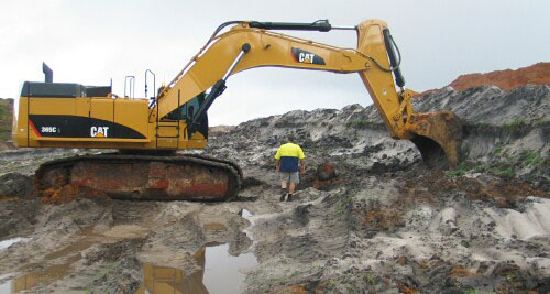
GW03 Landscape
Soil Profile Morphology:
Surface Soil
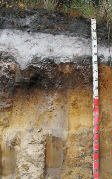
| A1 | 0 – 35 cm | Black (10YR2/1); loamy sand; soft surface condition; apedal; earthy fabric; firm consistence dry; pH 4.2; clear and wavy change to | 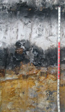 GW03 Profile. 3 metres depth. |
| A2 | 35 – 115 cm | Very pale grey (2.5Y7/1); sand; apedal; granular fabric; weak consistence dry; pH 4.4; clear wavy change to | |
Subsoil | |||
| Bh | 115 – 165 cm | Black (10YR2/1); loamy sand; apedal; earthy fabric; firm consistence moderately moist; pH 3.8; clear and wavy change to: | |
| Bs/Bhs | 165 – 220 cm | Brown (10YR5/3) with many distinct dark brown (10YR3/3) mottles; cemented sand/coffee rock; massive; granular fabric; very strong consistence dry; ferruginised sandstone pan; pH 5.1; clear change to: | |
| C1 | 220 – 300 cm | Brownish yellow (10YR6/4); sand; apedal; granular fabric; firm consistence moderately moist; few ferruginised sandstone; pH 4.5; clear change to:. | |
| C2 | 220 – 300 cm | Brownish yellow (10YR6/4); sand; apedal; granular fabric; firm consistence moderately moist; few ferruginised sandstone; pH 4.5; clear change to: |
GW03 Profile. 2 metres depth.
Shallower profiles occur in different topographic positions.
This profile is about 40m from the described profile.
Key Profile Features:
- Very deep bleached susbsurface horizon.
- Accumulation of organic matter (Bh) and organic matter/iron oxides (Bhs), commonly referred to as “coffee rock”, in deeper subsoil horizons.
Soil Profile Characteristics:
pH | Salinity Rating | |||
Surface (A1 horizon) | Extremely Acid | Low | Non-Sodic | - |
Subsoil (Bh horizon) | Extremely Acid | Very Low | Non-Sodic | - |
Deeper Subsoil (Bs/Bsh horizon) | Strongly Acid | Low | Non-Sodic | - |
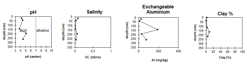
The soil profile is extremely acid. | The level of soluble salts is low to very low throughout the profile. | Aluminium levels are high at 1 metre depth. | Clay levels are low throughout the profile. |
|
Horizon | Horizon Depth (cm) | pH (water) | pH (CaCl2) | EC dS/m | Total Nitrogen g/100g | Organic Carbon g/100g | Exchangeable Cations | |||
Ca | Mg | K | Na | |||||||
Meq/100g | ||||||||||
A1 | 0-35 | 4.2 | 3.5 | 0.08 | 0.22 | 5 | 3.6 | 1.1 | <0.05 | 0.14 |
A2 | 35-115 | 4.4 | 4.2 | <0.05 | <0.05 | <0.05 | <0.05 | <0.05 | <0.05 | |
Bh | 115-165 | 3.8 | 3.2 | 0.006 | 0.98 | 0.11 | 0.32 | <0.05 | 0.08 | |
Bs/Bsh | 165-220 | 5.1 | 4.9 | 0.06 | 0.2 | 0.11 | <0.05 | 0.08 | ||
C1 | 220-300 | 4.5 | 4.3 | <0.05 | <0.05 | 0.08 | <0.05 | 0.06 | ||
C2 | 300-320+ | |||||||||
Horizon | Horizon Depth (cm) | Exchangeable Aluminium mg/kg | Exchangeable Acidity meq/100g | Field Capacitiy pF 2.5 | Wilting Point pF4.2 | Coarse Sand (0.2-2.0mm) % | Fine Sand (0.02-0.2mm) % | Silt (0.002-0.02mm) % | Clay (<0.002mm) % |
A1 | 0-15 | 23 | 22 | 13.9 | 6.7 | 20.5 | 67.8 | 3 | 2 |
A2 | 15-30 | <10 | <1.0 | 2.9 | 0.6 | 27 | 68.8 | 3.5 | 0.5 |
B21 | 30-80 | 190 | 12 | 4.6 | 2.2 | 20 | 75.3 | 0 | 2.5 |
B22 | 80-120 | 30 | 9.3 | 7.6 | 4.8 | 27.4 | 59.8 | 0 | 9.0 |
76 | 2.2 | 3.5 | 2.2 | 19.4 | 75.3 | 0 | 4.0 |
Profile Described By: David Rees (March 2011).

© State of Victoria (Agriculture Victoria) 1996 - .

This work, Victorian Resources Online, is licensed under a Creative Commons Attribution 4.0 licence. You are free to re-use the work under that licence, on the condition that you credit the State of Victoria (Agriculture Victoria) as author, indicate if changes were made and comply with the other licence terms.
The licence does not apply to ‘branding’ or some ‘images or photographs’ that may be owned by third parties. We ask you to seek prior approval to use images using the VRO feedback form. Access to higher quality images can also be provided on request.
This page was last updated on .