
PPW7
Aust. Soil Class.: Endocalcerous-Endohypersodic, Epipedal, Aquic (Brown) VERTOSOL
Northcote Factual Key:Ug 5.24
Great Soil Group:: brown clay (of grey, brown and red clay group)
Previous Soil Type (Skene 1954): Sunrise clay loam
Maher and Martin (1979) map unit: 7
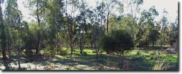
General Landscape Description: Level plain.
Site Description: Agroforestry reserve
Geology: Quaternary alluvial (prior stream) and aeolian deposits.
 WP4 Landscape |
Soil Profile Morphology
Surface Soil | 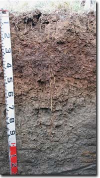 PPW7 Profile | ||
A1 | 0-20 cm | Brown (7.5YR4/4); light medium clay; strong very coarse subangular blocky, parting to medium-strong coarse blocky structure; surface cracks; pH 6.4; clear change to: | |
Subsoil | |||
B21 | 20-40 cm | Dark reddish brown (5YR3/4) with many yellowish red (5YR5/6) mottles; medium heavy clay; strong coarse-medium subangular blocky structure; pH 7.4: | |
B22 | 40-60 cm | Strong brown (7.5YR5/6); heavy clay; strong coarse blocky structure; slickensides present; pH 8.6; clear change to: | |
B23k | 60-90 cm | Light brownish grey (2.5Y6/2) with strong brown (7.5YR4/6) mottles common; medium heavy clay; strong coarse subangular blocky structure; few (5%) fine semi-hard calcareous nodules (1-3 mm size); pH 9.0; gradual change to: | |
B24k | 90-140 cm | Light brownish grey (2.5Y6/2) with weak red (2.5YR6/4) diffuse mottles; strong very fine lenticular structure (in patches); few (5%) fine calcareous nodules (1-2 mm); some manganese staining; pH 9.1. | |
Key Profile Features
- Clay texture throughout soil profile.
- Significant profile cracking when dry (with surface cracking).
- Vertic properties in subsoil (i.e. slickensides and lenticular structure).
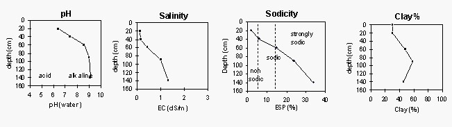
Soil Profile Characteristics
pH | Salinity Rating | |||
Surface (A1 horizon) | Slightly Acid | Very Low | Non-Sodic | None1 |
Subsoil (B21 horizon) | Strongly Alkaline | Low | Sodic | Moderate-Strong1 |
Deeper subsoil (at 90-140 cm) | Very Strongly Alkaline | High | Strongly Sodic | Strong |
| 1Strong to complete dispersion after remoulding | ||||
 |
Horizon | Horizon Depth (cm) | pH (water) | pH CaCl2 | EC dS/m | NaCl % | Exchangeable Cations | Ex Al mg/kg | Ex Ac meq/100g | Field pF2.5 | Wilting Point pF4.2 | Coarse Sand (0.2-2.0mm) | Fine Sand (0.02-0.2mm) | Silt (0.002-0.02mm) | Clay (<0.002mm) | |||
Ca | Mg | K | Na | ||||||||||||||
meq/100g | |||||||||||||||||
A1 | 0-20 | 6.4 | 5.7 | 0.12 | 7.9 | 2.4 | 2.0 | 0.51 | <10 | 7.0 | 28.0 | 7.9 | 8 | 39 | 20 | 30 | |
B21 | 20-40 | 7.4 | 6.6 | 0.14 | 11 | 6.1 | 2.3 | 1.7 | 5.7 | 36.2 | 18.8 | 3 | 26 | 20 | 48 | ||
B22 | 40-60 | 8.6 | 8.0 | 0.43 | 0.02 | 12 | 18 | 3.6 | 5.6 | 59.1 | 29.3 | 2 | 17 | 24 | 58 | ||
B23k | 60-90 | 9.0 | 8.6 | 1.0 | 0.02 | 8.3 | 24 | 3.2 | 11 | 63.9 | 29.7 | 1 | 17 | 36 | 45 | ||
B24k | 90-140 | 9.1 | 8.6 | 1.3 | 0.04 | 5.9 | 21 | 2.4 | 15 | 65.5 | 30.5 | ||||||
<2µm Clay Mineralogy | |||||||
Horizon | Depth cm | Quartz | Mica/Illite | Kaolin | Goethite | Orthclase | Smectite |
B21 | 20-40 | 8 | 35 | 41 | 3 | <1 | 12 |
B24k | 90-140 | 9 | 17 | 14 | - | <1 | 60 |
2µm Cation Exchange Capacity | ||||||||||||
Horizon | Depth cm | SiO2 % | Al2O3 % | MgO % | P2O5 % | K2O % | TiO2 % | MnO % | Fe2O3 % | BaO % | Sum % | CEC cmol/kg |
B21 | 20-40 | 47.2 | 22.8 | 1.2 | 0.3 | 2.6 | 1.2 | 0.0 | 9.1 | 3.2 | 87.7 | 43 |
B24k | 90-140 | 54.0 | 20.1 | 1.6 | 3.2 | 2.1 | 1.2 | 0.0 | 8.8 | 4.6 | 92.6 | 61 |
Management Considerations:
Whole Profile
- The soil profile displays strong vertic features (i.e. cracking, slickensides, lenticular peds). This indicates that significant shrinking and swelling occurs during wetting and drying cycles. This may disturb the roots of some plants and has engineering implications (e.g. disturbance to fencelines and buildings).
- In wet years, much of the lower soil profile is likely to be saturated. The grey subsoil indicates reduced conditions.
- Disturbance of clayey soils like these should be avoided if the soil is wet (i.e. wetter than the plastic limit). At such moisture conditions, excessive tillage, trafficking or over-stocking could result in soil structural damage (e.g. compaction). Ideally, activities such as these should only take place on clay soils when the soil is drier than the plastic limit – down to at least the tillage depth.
- The surface soil disperses strongly to completely after remoulding. This indicates that excessive cultivation or over-stocking when the soil is moist-wet may lead to structural degradation (e.g. surface crusting, exacerbated hardsetting). Bare soil is also likely to suffer damage from raindrop action.
- The dense and coarsely structured subsoil is strongly sodic and dispersive. This indicates that root and water movement into the subsoil will be restricted.
- The level of soluble salts from 60 cm depth may restrict the growth of deeper-rooted salt sensitive species.
- The subsoil is strongly to very strongly alkaline throughout. This indicates that phosphorus and some trace elements (such as iron, manganese, copper and zinc) may be poorly available to plants. Deficiencies should be determined by plant tissue analysis.
Soil profile described by Mark Imhof and Siggy Engleitner (30 April, 2004).

© State of Victoria (Agriculture Victoria) 1996 - .

This work, Victorian Resources Online, is licensed under a Creative Commons Attribution 4.0 licence. You are free to re-use the work under that licence, on the condition that you credit the State of Victoria (Agriculture Victoria) as author, indicate if changes were made and comply with the other licence terms.
The licence does not apply to ‘branding’ or some ‘images or photographs’ that may be owned by third parties. We ask you to seek prior approval to use images using the VRO feedback form. Access to higher quality images can also be provided on request.
This page was last updated on .