
LCA Cardinia Shire - Tech Report No. 29 - Chapter 4.1
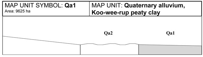
Qa1 | Qa2 | Qa3 | Qa4 | Qa5 | Qa6 | Qa7 | Qa8 | Qa9 | Qa10 | Qa11 | Qa12
4.1 Quaternary alluvial map units (Qa)
There are 12 alluvial map units found in the Cardinia Shire. Considerable variation occurs within soils of the alluvial units, particularly in the area of the old Koo-wee-rup swamp.
A number of studies have been carried out in the alluvial area describing the different alluvial soils. The first study of this area was made by Goudie (1942). A study of these soils was also carried out by Sargeant (1975) and reported in A Soil Survey of the Westernport Bay Catchment. A further study of the swamp was carried out by Sargeant (1993), A Soil Quality Assessment, Horticultural Preservation Zone Amendment L71. The boundaries used in the alluvial area are taken mostly from Sargeant’s study of the Horticultural Preservation Zone. Twelve different soil types were identified in this study. Eight of these represent significant areas within the Shire, the remaining four cover minor areas of the Horticultural Preservation Zone.
The alluvial soils can be differentiated into two major soil groups; swamp soils and the swamp fringe soils. The swamp soils have a ‘peaty’ top soil with an accumulation of organic matter up to 30 cm in depth. The swamp fringe soils are similar to the soils occurring higher in the catchment, including those that occur in association with Cardinia Creek and Bunyip River. These soils are lower in organic matter and generally have a higher sand content throughout the profile.
Those areas designated with sandy ridges indicate a landscape with greater than 20 per cent low sandy ridges. These ridges are remnants of the beds and levee banks of prior streams. Weathering granite and granodiorite are the major sources of quartz gravel and sand observed in the soil profiles within the sandy ridges. Gravel and coarse sandy fragments are common higher in the catchment, with finer clay sediments deposited lower in the catchment.
Land management considerations
The major land management considerations in these units include inundation, flooding and salinity.
Agriculture is the major land use within the alluvial areas, particularly horticulture, dairying and grazing. A Horticultural Preservation Zone has been established to protect the most productive alluvial soils used for intensive agriculture. In addition, an amendment to the planing scheme prohibits subdivision in this zone. These alluvial areas include map units Qa1, Qa2 and Qa6 (these are described by Sargeant (1993) as Koo-wee-rup peaty clay, Koo-wee-rup peaty clay with sandy ridges, and Dalmore clay (non-peaty)).
Minor residential development occurs outside the Horticultural Preservation Zone.
Some soils, particularly the Dalmore clays, are Vertosols (cracking clays); these alluvial soils have poor drainage and low permeability. This is mainly caused by the high sodicity in the subsoil. This also means that the internal drainage of these soils will be relatively poor.
The presence of an extensive drainage system mitigates against serious flooding events, however in exceptional circumstances floods may still occur. Localised ponding and minor inundation may occur during winter months. Localised ponding will cause problems with grazing lands such as soil compaction and pasture damage. Areas with sandy ridges are better drained and have higher soil water permeability than the clay soils. These sandy soils are preferred for grazing in the winter months.
Where site drainage and permeability are poor, a high risk of septic tank failure is present. An alternative form of effluent disposal should be investigated in these circumstances.
Significant areas of salt affected land have been recognised in the alluvial areas. Salting has the potential to significantly reduce agricultural production and may cause considerable damage to foundations, plumbing and gardens in residential areas. Where salting occurs in agricultural zones, it will require careful management to minimise loses in production and soil loss through sheet erosion. In residential areas, it may be necessary to consider rezoning options and prohibit further development on land known to be affected by salting. Salting is considered a very high hazard and may require long term remedial action at a catchment wide level, if control is to be achieved. Bare soils and the presence of spiny rush are good indicators of salinity.
Soils of Quaternary Alluvial origin
 Plate 1 - Map Unit Qa2 - Grey Kandosol | 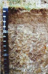 Plate 2 - Map Unit Qa3 - Grey Dermosol |
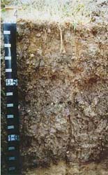 Plate 3 - Map Unit Qa4 - Grey Dermosol | 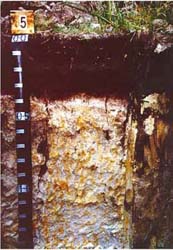 Plate 4 - Map Unit Qa5 - Podosol/Kurosol |
 A. GENERAL DESCRIPTION
This alluvial plain is situated in an area which was once part of an extensive Koo-wee-rup Swamp. The Koo-wee-rup peaty clay soil has organic peaty topsoils and peaty clay subsoils, and is highly valued for intensive agriculture. Three different phases of this soil were described by Goudie (1942). They include Normal Phase, Burnt Peat phase and Deep Peat phase. Each of these variations exist in the study area, however only the Normal Peat phase was studied in detail. The three types of Koo-wee-rup peat are similar, however due to scale restrictions all types have been mapped as Koo-wee-rup peaty clay. These soils generally have a clay loam to light peaty clay topsoil varying in depth from 25-40 cm; most topsoils are around 30 cm deep. In cultivated areas the AO horizon is often shallower or disappears completely. Since the swamp was drained, most of the peat has been lost due to shrinkage, burning of the peat and blowing of the topsoil. Grey medium to heavy clays are found in the subsoil with mottling increasing with depth. Varying amounts of coarse sand and grit may be found in the subsoil. The depth to seasonal watertable is variable; it may be shallower in some areas during winter and spring.
SITE CHARACTERISTICS
| Parent Material Age: | Quaternary | Depth to Seas. Watertable: | > 1.5 m (variable) | |
| Parent Material Lithology: | Alluvium | Flooding Risk: | Low | |
| Landform Pattern: | Alluvial plain | Drainage: | Poorly Drained | |
| Landform Element: | Swamp | Rock Outcrop: | Nil | |
| Slope a) common: | < 1% | Depth to Hard Rock: | > 1.5 m | |
| Slope b) range: | 0-1% | |||
| Potential Recharge to Groundwater: | Low | |||
| Major Native Vegetation Species: | Melaleuca | |||
| Present Land Use: | Horticulture, dairy, grazing | |||
| Length of Growing Season: | April -November (8 months) | |||
LAND DEGRADATION
Degradation Processes | Water Erosion | Wind Erosion | Mass Movement | Salting | Acidification | |
sheet/rill | gully | |||||
| Susceptibility | Very low | Low | Very low | Low | Low | Moderate |
| Incidence | Very low | Very low | Low | Very low | Low | NA |
B. SOIL PROFILE
PROFILE DESCRIPTION
| Site C5 | ||
A0 | 0-10 cm | Organic matter |
A1 | 10-30 cm | Black (10YR2/1) peaty light clay, strong subangular blocky structure, peds <2 mm, rough fabric, firm consistence, pH 5.3. Clear transition to: |
B1 | 30-50 cm | Very dark grey (10YR3/1) heavy clay, very few fine faint yellow mottles, weak to moderate prismatic structure, peds 10-20 mm, smooth fabric, firm consistence. Gradual transition to: |
B21 | 50-70 cm | Very dark grey (10YR3/1) heavy clay, very few fine faint yellow mottles, weak prismatic structure, peds 10-20 mm, smooth, firm consistence, pH 5.3. Gradual transition to: |
B22 | 70-90 cm | Very dark grey (10YR3/1) heavy clay, very few fine faint yellow mottles, weak prismatic structure, peds 10-20 mm, smooth fabric, firm consistence, pH 5.5. Gradual transition to: |
B23 | 90-120 cm | Dark grey (10YR4/1) heavy clay, coarse distinct yellow mottles are common, moderate prismatic and subangular blocky structure, peds 10-20 mm, smooth fabric, firm consistence, pH 4.9. Diffuse transition to: |
B24 | 120-150+cm | Grey (10YR5/1) heavy clay, many very coarse prominent yellow mottles, moderate prismatic structure, peds 20-50 mm, smooth, firm consistence. |
Classification
| Factual Key: | Uf6.22 |
| Australian Soil Classification: | Humose-Mottled, Eutrophic, Black Dermosol; thick, slightly gravelly, peaty/clayey, very deep (confidence level 2) |
| Unified Soil Group: | CH |
Interpretation of Laboratory analysis
Horizon | pH (CaCl2) | % Gravel | EC (salts) | Nutrient Status | P | K | Al | Organic Matter | Dispersibility |
A1 | 4.5 | 5 | VL | H | D | S | S | H | L |
B21 | 4.3** | > 2 | VL | M | D | S | T | M | M |
B22 | NA | > 2 | NA | NA | NA | NA | NA | NA | M (est) |
B23 | 4.1** | > 2 | VL | M | D | S | T | VL | M |
T: Potentially Toxic NA: Not Available * see Appendix D for analytical results ** Strongly Acidic
Soil Profile Characteristics:
| Permeability: | Moderate (average 105 mm/day, range 95-220 mm/day) |
| Available Water Capacity: | Very high (260 mm H2O) |
| Linear Shrinkage (B horizon): | Moderate (16%) |
C. LAND CAPABILITY ASSESSMENT
Land Use | Class | Major Limiting Feature(s)/Land Use |
| Agriculture | C2T1S2 | Nil |
| Effluent Disposal (septic tanks) | 5 | Drainage |
| Farm Dams | 3-4 | Permeability |
| Building Foundations slab stumps/footings | 5 5 | Drainage Drainage |
| Secondary Roads | 5 | Drainage |
| Rural Residential development | 5 | Effluent disposal, building foundations, secondary roads |

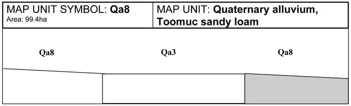
This alluvial plain also occurs in the Koo-wee-rup Swamp but has areas greater than 20 per cent composed of low sandy ridges. These ridges are remnants of prior streams. The sand found in the sandy ridges can vary from fine sand to coarse sand and gravel. Because of this distribution, the soils of this unit are highly variable. Compared with other swamp soils, the water holding capacity and fertility is lower, consequently productivity is lower. The texture of these soils ranges markedly from sands to clays due to the presence of intermittent sand lenses. There are no major limitations for agricultural production, although where the A11 is shallow, the poor conditions in the A12 horizon may limit productivity. The low nutrient content may have been caused by leaching of nutrients through the sandy soils, or production without replacement fertilisers. The depth to seasonal watertable is variable; it may be shallower in some areas during winter and spring, particularly in the depressions. When this is the case the land capability classes should be adjusted accordingly.
SITE CHARACTERISTICS
| Parent Material Age: | Quaternary | Depth to Seas. Watertable: | > 1.5 m (variable) | |
| Parent Material Lithology: | Alluvium | Flooding Risk: | Low | |
| Landform Pattern: | Rises | Drainage: | Imperfectly drained | |
| Landform Element: | Channel bench | Rock Outcrop: | Nil | |
| Slope a) common: | 1% | Depth to Hard Rock: | > 1.5 m | |
| Slope b) range: | 1-3% | |||
| Potential Recharge to Groundwater: | Low | |||
| Major Native Vegetation Species: | Melaleuca | |||
| Present Land Use: | Grazing | |||
| Length of Growing Season: | 8 months | |||
LAND DEGRADATION
Degradation Processes | Water Erosion | Wind Erosion | Mass Movement | Salting | Acidification | |
sheet/rill | gully | |||||
| Susceptibility | Very low | Very low | Very low | Low | Low | Moderate |
| Incidence | Very low | Very low | Very low | Very low | Low | NA |
B. SOIL PROFILE
PROFILE DESCRIPTION
| Site S2 | ||
A11 | 0-25 cm | Very dark brown (10YR3/1) organic fine sandy clay loam, moderate lenticular structure, rough fabric, peds 10-20 mm, firm consistence, pH 5.3. Clear transition to: |
A12 | 25-80 cm | Dark grey (10YR4/1) fine sandy clay loam, sporadically bleached (10YR8/1) when dry, many fine distinct, light brownish grey mottles, weak lenticular structure, peds 20-50 mm, rough fabric, firm consistence, pH 5.2. Gradual transition to: |
B1 | 80-105 cm | Greyish brown (10YR5/2) sandy clay, weak lenticular structure, peds 20-50 mm, rough fabric, firm consistence, pH 5.2. Gradual transition to: |
B2 | 105-150+ cm | Light grey (7.5YR7/0) light clay with sand, medium distinct strong brown mottles and coarse distinct reddish yellow mottles are common, weak polyhedral structure, peds 20-50 mm, rough and smooth fabric, firm consistence, pH 5.4. |
Classification
| Factual Key: | Gn3.81 (major), Gn4.81, Uf6.22 (minor) |
| Australian Soil Classification: | Melanic-Mottled, Mesotrophic, Grey KANDOSOL; medium, non-gravelly, peaty/clayey, very deep (confidence level 2) |
| Unified Soil Group: | CL |
Interpretation of Laboratory ANAlysis*
Horizon | pH (CaCl2) | % Gravel | EC (salts) | Nutrient Status | P | K | Al | Organic Matter | Dispersibility |
A11 | 4.7 | < 1 | VL | L | D | D | T | H | VL |
A12 | 4.4** | 0 | VL | VL | D | D | T | VL | L |
B1 | 4.3** | 0 | VL | VL | D | D | T | VL | M |
B2 | 4.3** | 0 | VL | L | D | D | T | VL | L |
T: Potentially Toxic NA: Not Available * see Appendix D for analytical results ** Strongly Acidic
Soil Profile Characteristics:
| Permeability: | Moderate (average 230 mm/day, range 110-355 mm/day) |
| Available Water Capacity: | Very high (283 mm H2O) |
| Linear Shrinkage (B horizon): | Moderate (14%) |
C. LAND CAPABILITY ASSESSMENT
| Land Use | Class | Major Limiting Feature(s)/Land Use |
| Agriculture | C2T1S2 | Nil |
| Effluent Disposal (septic tanks) | 4 | Drainage |
| Farm Dams | 4 | Permeability |
| Building Foundations slab stumps/footings | 4 4 | Drainage Drainage |
| Secondary Roads | 4 | Drainage |
| Rural Residential Development | 4 | Secondary roads, farm dams, effluent disposal, building foundations |
A. GENERAL DESCRIPTION
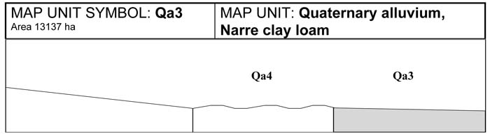
This alluvial plain is present along the fringe of the former Koo-wee-rup Swamp. The soil is a grey Kandosol (Narre clay loam) similar to the swamp fringe soil identified by Goudie (1942). Narre clay loams were formed on the margins of the old swamp and were not waterlogged over a sufficient length of time to allow formation and accumulation of peat. The surface soils range from a sandy loam to light clay over medium to heavy clays. The A horizons of these soils often contain significant amounts of coarse sand. Drainage and permeability of these soils is often poor and water will often pond for long periods after rainfall. The depth to seasonal watertable is variable; it can be shallower in some areas during winter and spring. When this is the case, the land capability classes should be adjusted accordingly. These soils are often used for grazing rather than horticulture. Pugging of the top soil will occur if paddocks are overstocked in winter.
SITE CHARACTERISTICS
| Parent Material Age: | Quaternary | Depth to Seas. Watertable: | > 1.5 m (variable) | |
| Parent Material Lithology: | Alluvium | Flooding Risk: | Low | |
| Landform Pattern: | Alluvial plain | Drainage: | Moderately well drained | |
| Landform Element: | Plain | Rock Outcrop: | Nil | |
| Slope a) common: | 1% | Depth to Hard Rock: | > 1.5 m | |
| Slope b) range: | 0-3% | |||
| Potential Recharge to Groundwater: | Low | |||
| Major Native Vegetation Species: | Melaleuca | |||
| Present Land Use: | Grazing (major), horticulture (minor) | |||
| Length of Growing Season: | 8 months | |||
LAND DEGRADATION
Degradation Processes | Water Erosion | Wind Erosion | Mass Movement | Salting | Acidification | |
sheet/rill | gully | |||||
| Susceptibility | Very low | Very low | Very low | Low | Moderate | Moderate |
| Incidence | Very low | Very low | Very low | Very low | Moderate | NA |
B. SOIL PROFILE
PROFILE DESCRIPTION
| Site S3 | ||
A1 | 0-30 cm | Very dark grey brown (10YR3/2) light clay, strong subangular blocky structure, peds 5-10 mm, rough fabric, firm consistence, pH 5.3. Abrupt transition to: |
A2 | 30-60 cm | Greyish brown (10YR5/2) coarse sandy clay, bleached (10YR8/2) when dry, weak polyhedral structure, peds 10-20 mm, rough fabric, very firm consistence, pH 5.0. Diffuse transition to: |
B2 | 60-150+ cm | Grey (10YR6/1) medium clay, many coarse prominent yellowish brown mottles, moderate polyhedral structure, peds 10-20 mm, smooth fabric, firm consistence, pH 4.6. |
Classification
| Factual Key: | Gn3.91 |
| Australian Soil Classification: | Melanic-Mottled, Eutrophic, Grey DERMOSOL; thick, non-gravelly, clayey/clayey, very deep (confidence level 2) |
| Unified Soil Group: | CL |
Interpretation of Laboratory ANAlysis*
Horizon | pH (CaCl2) | % Gravel | EC (salts) | Nutrient Status | P | K | Al | Organic Matter | Dispersibility |
A1 | 4.6 | < 1 | VL | M | S | S | T | H | VL |
A2 | 4.2** | < 1 | VL | VL | D | D | T | L | M |
B2 | 4.0** | < 1 | L | L | D | D | T | VL | L |
T: Potentially Toxic NA: Not Available * see Appendix D for analytical results ** Strongly Acidic
Soil Profile Characteristics:
| Permeability: | Slow (average 20 mm/day, range 3-40 mm/day) |
| Available Water Capacity: | Very high (260 mm H2O) |
| Linear Shrinkage (B horizon): | Low (12.5 %) |
C. LAND CAPABILITY ASSESSMENT
| Land Use | Class | Major Limiting Feature(s)/Land Use |
| Agriculture | C2T1S3 | Permeability-rainfall index |
| Effluent Disposal (septic tanks) | 4 | Permeability |
| Farm Dams | 3 | Depth to seasonal watertable, low dispersibility of subsoil, permeability |
| Building Foundations slab stumps/footings | 3 3 | Drainage, depth to watertable Drainage, depth to watertable, linear shrinkage |
| Secondary Roads | 3 | Drainage, linear shrinkage, USG subsoil |
| Rural Residential Development | 4 | Effluent disposal |
A. GENERAL DESCRIPTION
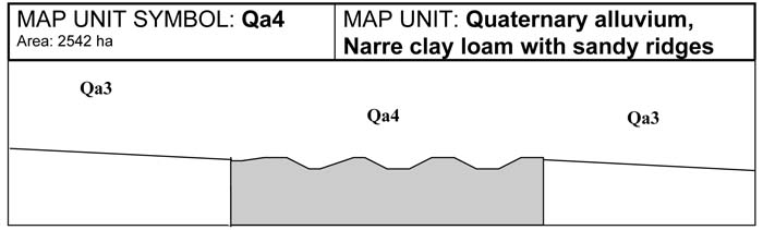
This alluvial plain also occurs along the fringe of the Koo-wee-rup Swamp, however the presence of sandy ridges distinguishes this unit from Qa3. The swamp fringe soil is similar to the Narre clay loam however the presence of fine, medium or coarse sands make the Narre clay loam with sandy ridges more suitable for grazing purposes. Soil fertility is not sufficient for horticulture. Drainage of these soils is more rapid than that of the Narre clay loam soils due to the high sand content. In the depressions the watertablemay be closer to the surface in the winter and spring months. When this is the case, the land capability classes should be adjusted accordingly.
SITE CHARACTERISTICS
| Parent Material Age: | Quaternary | Depth to Seas. Watertable: | > 1.5 m (variable) | |
| Parent Material Lithology: | Alluvium | Flooding Risk: | Low | |
| Landform Pattern: | Alluvial plain | Drainage: | Moderately well drained | |
| Landform Element: | Plain | Rock Outcrop: | Nil | |
| Slope a) common: | 1% | Depth to Hard Rock: | > 1.5 m | |
| Slope b) range: | 0-3% | |||
| Potential Recharge to Groundwater: | Low | |||
| Major Native Vegetation Species: | Melaleuca | |||
| Present Land Use: | Grazing | |||
| Length of Growing Season: | 8 months | |||
LAND DEGRADATION
Degradation Processes | Water Erosion | Wind Erosion | Mass Movement | Salting | Acidification | |
sheet/rill | gully | |||||
| Susceptibility | Very low | Very low | Very low | Low | Low | Low |
| Incidence | Very low | Very low | Very low | Very low | Low | NA |
B. SOIL PROFILE
PROFILE DESCRIPTION
| Site S4 | ||
| A1 | 0-30 cm | Dark greyish brown (10YR4/2) light clay, weak angular blocky structure, peds 10-20 mm, rough fabric, strong consistence, pH 5.1. Clear transition to: |
| B21 | 30-80 cm | Dark greyish brown (10YR4/2) medium clay, strong angular blocky structure, peds 10-20 mm and 20-50 mm, smooth fabric, strong consistence, pH 4.8. Gradual transition to: |
| B22 | 80-150 cm | Dark greyish brown (10YR4/2) gritty light clay, strong angular blocky and columnar structure, peds 20-50 mm and 200-500 mm smooth fabric, very firm consistence, pH 4.8. Clear transition to: |
| 2Cb | 150+ cm | Brown (10YR5/3) sand, apedal single grain, sandy (grains prominent), very weak consistence, pH 4.6. |
Classification
| Factual Key: | Uf6.23 |
| Australian Soil Classification: | Acidic, Mesotophic, Grey DERMOSOL; medium, non-gravelly, clayey/clayey, very deep (Confidence level 2) |
| Unified Soil Group: | MH |
Interpretation of Laboratory ANAlysis*
Horizon | pH (CaCl2) | % Gravel | EC (salts) | Nutrient Status | P | K | Al | Organic Matter | Dispersibility |
A1 | 4.3** | 0 | VL | M | S | S | T | H | VL |
B21 | 4.0** | 0 | VL | L | S | S | T | H | VL |
B22 | 4.0** | 0 | VL | L | S | S | T | L | M |
B3 | 3.9** | 0 | VL | VL | S | D | T | VL | L |
T: Potentially Toxic NA: Not Available * see Appendix D for analytical results ** Strongly Acidic
Soil Profile Characteristics:
| Permeability: | Moderate (average 165 mm/day, range 50-260 mm/day) |
| Available Water Capacity: | Very high (233 mm H20) |
| Linear Shrinkage (B horizon): | Moderate (13%) |
C. LAND CAPABILITY ASSESSMENT
| Land Use | Class | Major Limiting Feature(s)/Land Use |
| Agriculture | C2T1S2 | Nil |
| Effluent Disposal (septic tanks) | 3 | Moderately well drained |
| Farm Dams | 3-4 | Permeability |
| Building Foundations slab stumps/footings | 3 3 | Drainage, depth to watertable Drainage, depth to watertable |
| Secondary Roads | 3 | Drainage, depth to watertable, linear shrinkage |
| Rural Residential Development | 3-4 | Farm Dams |
A. GENERAL DESCRIPTION
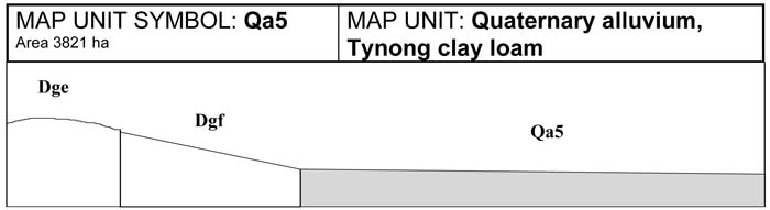
This alluvial plain occurs on the swamp fringe, adjacent to gently undulating granitic terrain. Subsequently, the Tynong clay loam soils have a high gravel and sand concentration throughout the profile. These soils are generally a clay loam over medium to heavy clay. Horizons of coffee rock, that forms a dense cemented pan, were observed where there is leaching of organic matter and iron oxides through the profile. Permeability is generally low and ponding often occurs after significant rain. These soil types are commonly used for grazing.
SITE CHARACTERISTICS
| Parent Material Age: | Quaternary | Depth to Seas. Watertable: | > 1.5 m | |
| Parent Material Lithology: | Alluvium | Flooding Risk: | Low | |
| Landform Pattern: | Alluvial plain | Drainage: | Moderately well drained | |
| Landform Element: | Plain | Rock Outcrop: | Nil | |
| Slope a) common: | 1% | Depth to Hard Rock: | > 1.5 m | |
| Slope b) range: | 0-3% | |||
| Potential Recharge to Groundwater: | Low | |||
| Major Native Vegetation Species: | Melaleuca, Messmate, Narrow-leaved Peppermint | |||
| Present Land Use: | Grazing | |||
| Length of Growing Season: | 8 months | |||
LAND DEGRADATION
Degradation Processes | Water Erosion | Wind Erosion | Mass Movement | Salting | Acidification | |
sheet/rill | gully | |||||
Susceptibility | Low | Very low | Very low | Low | Moderate | Moderate |
Incidence | Very low | Very low | Very low | Very low | Low | NA |
B. SOIL PROFILE
PROFILE DESCRIPTION
| Site S5 | ||
A11 | 0-10 cm | Very dark grey (5YR3/1) clay loam, moderate polyhedral structure, peds 10-20 mm, rough fabric, weak consistence, pH 4.5. Abrupt transition to: |
A12 | 10-25 cm | Dark grey (5YR4/1) sandy clay loam (coarse sand), moderate polyhedral structure, peds 5-10 mm, rough fabric, very weak consistence, pH 4.7. Clear transition to: |
Bhs | 25-35 cm | Dark brown (7.5YR3/2 ) organic pan (Coffee rock), massive structure, sandy fabric, strong consistence, pH 4.9. Gradual transition to: |
D1 | 35-70 cm | Pinkish grey (7.5YR7/2) coarse sandy clay, coarse distinct red mottles and coarse prominent reddish yellow mottles are common, moderate subangular blocky structure, peds 5-10 mm, rough fabric, firm consistence, pH 5.3. Clear transition: |
D2 | 70-150+ cm | Grey (7.5YR6/0) medium clay, many very coarse prominent reddish yellow mottles, moderate polyhedral structure, peds 10-20 mm, rough fabric, very firm consistence, pH 6.0. |
Classification
| Factual Key: | Uc5/Dy |
| Australian Soil Classification: | Parapanic, Humic, Semiaquic PODOSOL (over KUROSOL); medium, non-gravelly, clay loamy/clayey, very deep (confidence level 2) |
| Unified Soil Group: | CH |
Interpretation of Laboratory ANAlysis*
Horizon | pH (CaCl2) | % Gravel | EC (salts) | Nutrient Status | P | K | Al | Organic Matter | Dispersibility |
A11 | 3.7** | 0 | VL | VL | D | D | T | H | VL |
A12 | 3.7** | 0 | VL | VL | D | D | T | M | VL |
Bhs | 4.0** | 0 | VL | VL | D | D | T | H | L |
D1 | 4.2** | 0 | VL | VL | D | D | T | VL | M |
D2 | 5.6 | 0 | M | L | D | D | S | VL | L |
T: Potentially Toxic NA: Not Available * see Appendix D for analytical results ** Strongly Acidic
Soil Profile Characteristics:
| Permeability: | Slow (average 65 mm/day, range 35-85 mm/day) |
| Available Water Capacity: | High (200 mm H2O) |
| Linear Shrinkage (B horizon): | Moderate (17.5%) |
C. LAND CAPABILITY ASSESSMENT
| Land Use | Class | Major Limiting Feature(s)/Land Use |
| Agriculture | C2T1S3 | Permeability-rainfall index |
| Effluent Disposal (septic tanks) | 3-4 | Permeability, drainage |
| Farm Dams | 3 | Linear shrinkage, depth to seasonal watertable, permeability |
| Building Foundations slab stumps/footings | 3 3 | Drainage, depth to seasonal watertable Linear shrinkage, drainage, depth to seasonal watertable |
| Secondary Roads | 3 | Linear shrinkage, drainage, USG subsoil |
| Rural Residential Development | 3 | Effluent disposal, farm dams, secondary roads, building foundations |
A. GENERAL DESCRIPTION
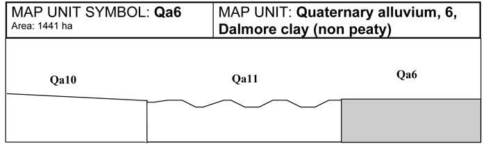
This alluvial plain is part of the former Koo-wee-rup Swamp. The Dalmore clay (non peaty) is similar to the Dalmore clay (Qa12), however it has a less peaty friable surface. The topsoil is dark grey to black medium to heavy clay. The subsoil is a dark grey heavy clay. Mottling of the subsoil increases as the soil depth increases. This soil is not considered as fertile as the Dalmore clay as there is less organic matter in the topsoil and subsoil. This soil type has not been commonly used for horticulture, however recently more of this soil type is being used for horticultural production. The high clay content of the topsoil makes management difficult; when dry it forms hard clods, and when wet becomes very sticky which is related to the sodicity of the soil. If the soil is worked when wet, smearing and compaction of the soil surface will occur. Pugging of the soil in winter by stock will have a similar effect. The high clay content of this soil means that the soil has a high shrink swell capacity and will crack when dry. This property has implications for engineering as fences, roads and foundations require a stable substrate. Acid topsoils and subsoils were noted in preliminary sites. Aluminium toxicity may be a problem in these soils.
SITE CHARACTERISTICS
| Parent Material Age: | Quaternary | Depth to Seas. Watertable: | > 1.5 m | |
| Parent Material Lithology: | Alluvium | Flooding Risk: | Low | |
| Landform Pattern: | Alluvial plain | Drainage: | Moderately well drained | |
| Landform Element: | Plain | Rock Outcrop: | Nil | |
| Slope a) common: | 1% | Depth to Hard Rock: | > 1.5 m | |
| Slope b) range: | 0-3% | |||
| Potential Recharge to Groundwater: | Low | |||
| Major Native Vegetation Species: | Melaleuca | |||
| Present Land Use: | Horticulture, some grazing | |||
| Length of Growing Season: | 8 months | |||
LAND DEGRADATION
Degradation Processes | Water Erosion | Wind Erosion | Mass Movement | Salting | Acidification | |
sheet/rill | gully | |||||
Susceptibility | Very low | Low | Very low | Low | Low | Moderate |
Incidence | Very low | Very low | Very low | Very low | Low | NA |
B. SOIL PROFILE
PROFILE DESCRIPTION
| Site C9 | ||
A1 | 0-40 cm | Black (10YR5/1) peaty light medium clay, strong subangular blocky structure (self-mulching), peds 2-5 mm, rough fabric, strong consistence, pH 5.9. Clear transition to: |
B21 | 40-90 cm | Black (2.5Y2.5/0) heavy clay, strong lenticular structure, slickensides, peds 20-50 mm, smooth fabric, very strong consistence, pH 5.7. Gradual transition to: |
B22 | 90-150+ cm | Black (5Y2.5/1) heavy clay, a few medium faint yellow and orange mottles, moderate lenticular and prismatic structure, slickensides, peds 10-20 mm, smooth fabric, very strong consistence, pH 5.4. |
Classification
| Factual Key: | Ug5.1 |
| Australian Soil Classification: | Epihypersodic, Self-mulching, Black VERTOSOL; non-gravelly, medium, fine/very fine, very deep (confidence level 2) |
| Unified Soil Group: | OH |
Interpretation of Laboratory ANAlysis*
Horizon | pH (CaCl2) | % Gravel | EC (salts) | Nutrient Status | P | K | Al | Organic Matter | Dispersibility |
A1 | 4.9 | < 2 | VL | VH | S | S | T | H | VL |
B21 | 4.8 | < 2 | VL | VH | S | S | T | H | M-H |
B22 | 4.7 | < 2 | VL | H | S | S | T | M | M-H |
T: Potentially Toxic NA: Not Available * see Appendix D for analytical results ** Strongly Acidic
Soil Profile Characteristics:
| Permeability: | Slow (average 23 mm/day, range 3-40 mm/day) |
| Available Water Capacity: | Very high (> 200 mm H2O) |
| Linear Shrinkage (B horizon): | Moderate (17%) |
C. LAND CAPABILITY ASSESSMENT
| Land Use | Class | Major Limiting Feature(s)/Land Use |
| Agriculture | C2T1S3 | Permeability-rainfall index |
| Effluent Disposal (septic tanks) | 4 | Permeability |
| Farm Dams | 5 | Suitability of subsoil |
| Building Foundations slab stumps/footings | 3 3 | Drainage Drainage |
| Secondary Roads | 5 | USG |
| Rural Residential Development | 5 | Farm dams, secondary roads |

A. GENERAL DESCRIPTION
This map unit is similar to the former swampy plains of Qa6 and Qa12. The Dalmore clay (heavy surface) is similar to Dalmore clay (Qa12), however it lacks the peaty friable surface. The topsoil is dark grey to black medium to heavy clay and the subsoil is a dark grey heavy clay. As soil depth increases there is an increase in mottling of the subsoil. The high clay content of the topsoil makes it difficult to manage. When the soil is dry hard clods form and when wet the soil becomes very sticky, which is related to the sodicity of the soil. If the soil is worked when wet, smearing and compaction of the soil surface will occur. Pugging of the soil in winter by stock will have a similar effect. The high clay content of this soil means that the soil has a high shrink swell capacity and will crack when dry. This property has implications for engineering as fences, roads and foundations need a stable substrate. The profile is commonly sodic and the subsoil acidic. Even though the flood risk for this unit is considered low, in wet years these soils will be inundated for long periods over winter and the watertable may be at or near the surface. When this is the case the land capability classes should be adjusted accordingly.
SITE CHARACTERISTICS
| Parent Material Age: | Quaternary | Depth to Seas. Watertable: | > 1.5 m | |
| Parent Material Lithology: | Alluvium | Flooding Risk: | Low | |
| Landform Pattern: | Alluvial plain | Drainage: | Moderately well drained | |
| Landform Element: | Plain | Rock Outcrop: | Nil | |
| Slope a) common: | 1% | Depth to Hard Rock: | > 1.5 m | |
| Slope b) range: | 0-3% | |||
| Potential Recharge to Groundwater: | Low | |||
| Major Native Vegetation Species: | Melaleuca | |||
| Present Land Use: | Grazing | |||
| Length of Growing Season: | 8 months | |||
LAND DEGRADATION
Degradation Processes | Water Erosion | Wind Erosion | Mass Movement | Salting | Acidification | |
sheet/rill | gully | |||||
Susceptibility | Very low | Low | Very low | Low | Low | Low |
Incidence | Very low | Very low | Very low | Very low | Low | NA |
B. SOIL PROFILE
PROFILE DESCRIPTION
| Site C8 | ||
A1 | 0-30 cm | Very dark grey (10YR3/1) medium clay, weak subangular blocky structure, peds 5-10 mm, rough fabric, firm consistence, pH 5.5. Clear transition to: |
B21 | 30-60 cm | Dark grey (10YR4/1) heavy clay, moderate lenticular structure, slickensides, peds 10-20 mm, smooth fabric, firm consistence, pH 5.6. Gradual transition to: |
B22 | 60-90 cm | Dark grey (10YR4/1) heavy clay, moderate lenticular structure, slickensides, peds 10-20 mm smooth fabric, firm consistence, pH 5.1. Gradual transition to: |
B3 | 90-110+ cm | Dark, greyish brown (10YR4/2) sandy clay, weak prismatic and subangular blocky structure, peds 10-20 mm, smooth fabric, firm consistence. |
Classification
| Factual Key: | Ug5.16 |
| Australian Soil Classification: | Epihypersodic-Endoacidic, Epipedal, Black VERTOSOL; slightly gravelly, medium fine/ medium fine, very deep (confidence level 2) |
| Unified Soil Group: | CH |
Interpretation of Laboratory ANAlysis*
Horizon | pH (CaCl2) | % Gravel | EC (salts) | Nutrient Status | P | K | Al | Organic Matter | Dispersibility |
A1 | 4.8 | < 10 | VL | M | D | S | S | H | L-M |
B21 | 4.5 | < 10 | VL | M | D | S | T | M | M-H |
B22 | 4.3** | < 10 | L | M | D | S | T | L | M-H |
T: Potentially Toxic NA: Not Available * see Appendix D for analytical results ** Strongly Acidic
Soil Profile Characteristics:
| Permeability: | Moderate (average 165 mm/day, range 50-260 mm/day) |
| Available Water Capacity: | Very high (> 200 mm H2O) |
| Linear Shrinkage (B horizon): | Moderate (16 %) |
C. LAND CAPABILITY ASSESSMENT
| Land Use | Class | Major Limiting Feature(s)/Land Use |
| Agriculture | C2T1S2 | Nil |
| Effluent Disposal (septic tanks) | 3 | Drainage |
| Farm Dams | 4 | Permeability |
| Building Foundations slab stumps/footings | 3 3 | Drainage Drainage, linear shrinkage |
| Secondary Roads | 3 | Drainage, linear shrinkage, USG subsoil |
| Rural Residential Development | 4 | Farm dams |
A. GENERAL DESCRIPTION
This alluvial plain is part of the former Koo-wee-rup Swamp, and is often found in association with Qa3. The soil contains large amounts of sand to a depth of about 60 cm. Much of this material would have been deposited by the nearby Cardinia Creek. The topsoil is a sand to sandy loam over a lighter textured bleached A2 horizon. The subsoil is generally sodic and highly dispersive. Iron oxide nodules may be found in the A2 horizon and the clay subsoil is generally mottled clay which indicates periodic waterlogging. The topsoil tends to have a low fertility and for this reason the soil is more commonly used for grazing rather than horticulture.
SITE CHARACTERISTICS
| Parent Material Age: | Quaternary | Depth to Seas. Watertable: | > 1.5 m | |
| Parent Material Lithology: | Alluvium | Flooding Risk: | Low | |
| Landform Pattern: | Alluvial plain | Drainage: | Moderately well drained | |
| Landform Element: | Plain | Rock Outcrop: | Nil | |
| Slope a) common: | 1% | Depth to Hard Rock: | > 1.5 m | |
| Slope b) range: | 0-3% | |||
| Potential Recharge to Groundwater: | Low | |||
| Major Native Vegetation Species: | Melaleuca | |||
| Present Land Use: | Grazing, horticulture | |||
| Length of Growing Season: | 8 months | |||
LAND DEGRADATION
Degradation Processes | Water Erosion | Wind Erosion | Mass Movement | Salting | Acidification | |
sheet/rill | gully | |||||
Susceptibility | Low | Low | Very low | Low | Moderate | Moderate |
Incidence | Very low | Very low | Very low | Very low | Low | NA |
B. SOIL PROFILE
PROFILE DESCRIPTION
| Site GP21 | ||
A1 | 0-25 cm | Dark grey brown (10YR4/2) sandy loam, weak subangular blocky structure, peds 5-10 mm, rough fabric, very weak consistence, pH 5.6. Abrupt transition to: |
A2 | 25-45 cm | Greyish brown (10YR5/2) loamy sand, bleached (10YR8/2) when dry, weak subangular structure, peds 10-20 mm, rough fabric, very weak consistence, pH 5.7. Clear transition to: |
B2 | 44-120+ cm | Dark grey brown (10YR4/2) medium clay, many coarse prominent yellowish brown mottles, moderate polyhedral structure, peds 10-20 mm, rough fabric, firm consistence, pH 6.1. |
Classification
| Factual Key: | Dy3.41 |
| Australian Soil Classification: | Magnesic, Mottled-Subnatric, Grey SODOSOL; thick, non-gravelly, loamy/clayey, very deep (confidence level 2) |
| Unified Soil Group: | CL |
Interpretation of Laboratory ANAlysis*
Horizon | pH (CaCl2) | % Gravel | EC (salts) | Nutrient Status | P | K | Al | Organic Matter | Dispersibility |
A1 | 4.8 | < 1 | VL | L | NA | NA | NA | H | NA |
A2 | 4.6 | < 1 | VL | VL | NA | NA | NA | NA | NA |
B2 | 4.8 | < 1 | VL | L | NA | NA | NA | NA | H (est) |
T: Potentially Toxic NA: Not Available * see Appendix D for analytical results ** Strongly Acidic
Soil Profile Characteristics:
| Permeability: | Slow (average 20 mm/day, range 3-40 mm/day) |
| Available Water Capacity: | Very high (260 mm H2O) |
| Linear Shrinkage (B horizon): | Low (12.5 %) |
C. LAND CAPABILITY ASSESSMENT
| Land Use | Class | Major Limiting Feature(s)/Land Use |
| Agriculture | C2T1S3 | Permeability-rainfall index |
| Effluent Disposal (septic tanks) | 4 | Permeability |
| Farm Dams | 3 | Depth to seasonal watertable, permeability, low dispersibility of subsoil |
| Building Foundations slab stumps/footings | 3 3 | Depth to seasonal watertable, drainage Depth to seasonal watertable, drainage |
| Secondary Roads | 3 | Depth to seasonal watertable, drainage, USG subsoil |
| Rural Residential Development | 4 | Effluent disposal |
A. GENERAL DESCRIPTION
This alluvial plain occurs on the fringe of the former Koo-wee-rup Swamp to the south east of the Shire, south of Catani and Bayles. The soils of this unit are derived from deposition by the Lang Lang River, Gum Scrub, Yanathan and other creeks. This unit has occassional sandy ridges which are the remnants of prior stream banks and levees. The topsoils are generally grey or grey brown clay loams to light clay to a depth of 20-30 cm. The subsoils are generally sodic, with deep, mottled, medium to heavy clays. These soils are often used for grazing and dairying rather than horticulture.
SITE CHARACTERISTICS
| Parent Material Age: | Quaternary | Depth to Seas. Watertable: | > 1.5 m | |
| Parent Material Lithology: | Alluvium | Flooding Risk: | Low | |
| Landform Pattern: | Alluvial plain | Drainage: | Moderately well drained | |
| Landform Element: | Plain | Rock Outcrop: | Nil | |
| Slope a) common: | 1% | Depth to Hard Rock: | > 1.5 m | |
| Slope b) range: | 0-3% | |||
| Potential Recharge to Groundwater: | Low | |||
| Major Native Vegetation Species: | Melaleuca, Messmate, Narrow-leaved Peppermint | |||
| Present Land Use: | Grazing | |||
| Length of Growing Season: | 8 months | |||
LAND DEGRADATION
Degradation Processes | Water Erosion | Wind Erosion | Mass Movement | Salting | Acidification | |
sheet/rill | gully | |||||
Susceptibility | Low | Low | Very low | Low | Low | Low |
Incidence | Very low | Very low | Very low | Very low | Low | NA |
B. SOIL PROFILE
PROFILE DESCRIPTION
| Site C7 | ||
A1 | 0-30 cm | Very dark grey (10YR3/1) fine sandy clay loam, moderate subangular blocky structure, peds 10-20 mm, rough fabric, firm consistence, pH 5.4. Clear transition to: |
B1 | 30-80 cm | Dark grey (10YR4/1) light medium clay with silt, bleached (10YR7/2) when dry, coarse faint yellow and pale mottles are common, moderate prismatic structure, peds 20-50 mm, smooth fabric, strong consistence. Gradual transition to: |
B2 | 80-150+ cm | Grey (10YR6/2) heavy clay, many medium distinct yellow and pale mottles, moderate subangular blocky structure, peds 5-10 mm, smooth fabric, strong consistence, pH 6.8. |
Classification
| Factual Key: | Gn3.92 (major), Dy3.12 (minor) |
| Australian Soil Classification: | Melanic-Sodic, Eutrophic, Grey DERMOSOL; medium, non-gravelly, clay loamy/clayey, very deep (confidence level 2) |
| Unified Soil Group: | CH |
Interpretation of Laboratory ANAlysis*
Horizon | pH (CaCl2) | % Gravel | EC (salts) | Nutrient Status | P | K | Al | Organic Matter | Dispersibility |
A1 | 4.6 | 0 | L | L | D | S | T | H | L |
B1 | NA | 20 | NA | NA | NA | NA | NA | NA | H |
B2 | 6.3 | 20 | M | M | D | D | S | VL | H |
T: Potentially Toxic NA: Not Available * see Appendix D for analytical results ** Strongly Acidic
Soil Profile Characteristics:
| Permeability: | Slow ( average 20 mm/day, range 3-40 mm/day) |
| Available Water Capacity: | Very high (> 200 mm H2O) |
| Linear Shrinkage (B horizon): | Moderate (15%) |
C. LAND CAPABILITY ASSESSMENT
| Land Use | Class | Major Limiting Feature(s)/Land Use |
| Agriculture | C2T1S3 | Permeability-rainfall index |
| Effluent Disposal (septic tanks) | 4 | Permeability |
| Farm Dams | 4 | Dispersive subsoil |
| Building Foundations slab stumps/footings | 3 3 | Drainage Drainage, linear shrinkage |
| Secondary Roads | 3 | Drainage, linear shrinkage |
| Rural Residential Development | 4 | Effluent disposal, farm dams |
A. GENERAL DESCRIPTION
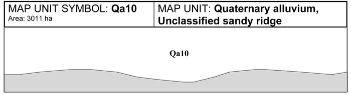
This unit represents a number of areas in the Shire where sand ridges occur. The sand may have been deposited by rivers and streams or may have been wind blown. The sand has been deposited on top of various materials and often varies in depth. The sand ridges consist mostly of pure sand apart from an accumulation of organic matter in the topsoil. Quite often the leaching of organic matter and iron oxides down the profile causes the build up of an organic pan or coffee rock. This pan will often form on top of a more impervious layer. The coffee rock occurs from between 30-100 cm. The high sand content means that nutrients leach out of the soil rapidly making them relatively infertile. Leaching of nutrients will also cause an increase in the acidity of the soil. These unclassified sand ridges occur close to the township of Cardinia, and south and east of Lang Lang. Land use is usually restricted to grazing and dairying, however soils with a shallow sandy soil over clay are increasingly being used for horticultural purposes. Plant available water capacity may be reduced due to the presence of the hardpan which restricts root penetration.
SITE CHARACTERISTICS
| Parent Material Age: | Quaternary | Depth to Seas. Watertable: | > 2.0 m | |
| Parent Material Lithology: | Alluvium | Flooding Risk: | Low | |
| Landform Pattern: | Sand plain, dune field | Drainage: | Moderately well drained | |
| Landform Element: | Dune, lunette | Rock Outcrop: | Nil | |
| Slope a) common: | 1% | Depth to Hard Rock: | > 2.0 m | |
| Slope b) range: | 0-3% | |||
| Potential Recharge to Groundwater: | Low | |||
| Major Native Vegetation Species: | Melaleuca | |||
| Present Land Use: | Grazing | |||
| Length of Growing Season: | 8 months | |||
LAND DEGRADATION
Degradation Processes | Water Erosion | Wind Erosion | Mass Movement | Salting | Acidification | |
sheet/rill | gully | |||||
| Susceptibility | Very low | Very low | Moderate | Low | Low | Moderate |
| Incidence | Very low | Very low | Very low | Very low | Low | NA |
B. SOIL PROFILE
PROFILE DESCRIPTION
| Site C1 | ||
A1 | 0-30 cm | Black (10YR2/1) loamy sand, weak subangular blocky structure, peds 10-20 mm, rough fabric, loose consistence, pH 5.2. Clear transition to: |
A2 | 30-90 cm | Dark grey (10YR5/2) sand, bleached (10YR7/1) when dry, weak subangular blocky structure, peds 5-10 mm rough fabric, very weak consistence, pH 6.0. Gradual transition to: |
Bhs | 90-105 cm | Dark brown (7.5YR4/3 ) organic pan (Coffee rock), apedal massive (structureless), strong consistence, pH 5.5. Gradual transition to: |
B2 | 105+ cm | Grey (10YR5/6) sandy clay, many coarse prominent pale brown mottles, weak subangular blocky structure, peds 5-10 mm, rough fabric, firm consistence, pH 4.8. |
Classification
| Factual Key: | Uc2 |
| Australian Soil Classification: | Humose, Humic, Semiaquic PODOSOL; thick, non-gravelly, sandy/clayey (confidence level 2) |
| Unified Soil Group: | CL |
Interpretation of Laboratory ANAlysis*
Horizon | pH (CaCl2) | % Gravel | EC (salts) | Nutrient Status | P | K | Al | Organic Matter | Dispersibility |
A1 | 4.7 | 0 | L | VL | S | S | S | H | VL |
A2 | 4.2** | 0 | VL | VL | S | D | T | VL | VL |
Bhs | NA | 0 | NA | NA | NA | NA | NA | NA | VL |
B2 | 4.0** | < 10 | L | L | D | D | S | VL | L |
T: Potentially Toxic NA: Not Available * see Appendix D for analytical results ** Strongly Acidic
Soil Profile Characteristics:
| Permeability: | Slow (average 65 mm/day, range 35-85 mm/day) |
| Available Water Capacity: | High (150-200 mm H2O) |
| Linear Shrinkage (B horizon): | Very low (6%) |
C. LAND CAPABILITY ASSESSMENT
| Land Use | Class | Major Limiting Feature(s)/Land Use |
| Agriculture | C2T1S3 | Susceptibility to wind erosion, permeability-rainfall index |
| Effluent Disposal (septic tanks) | 3 | Drainage, permeability |
| Farm Dams | 3 | Permeability |
| Building Foundations slab stumps/footings | 3 3 | Drainage Drainage |
| Secondary Roads | 3 | Drainage, USG |
| Rural Residential Development | 3 | Effluent disposal, farm dams, building foundations, secondary roads |
A. GENERAL DESCRIPTION
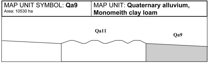
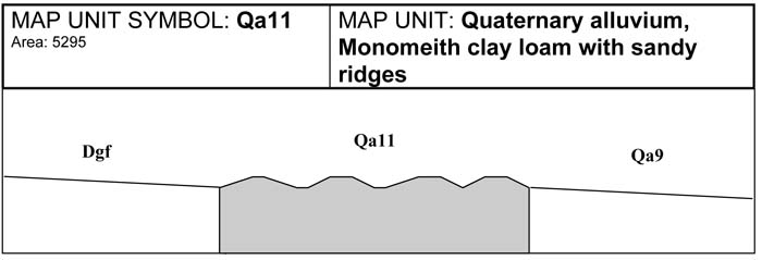
This alluvial plain has developed on the margins of the Koo-wee-rup swamp and was not waterlogged long enough for the formation and accumulation of peat. The sandy ridges of this unit indicate that more than 20 per cent of the area is made up of low rises with soils comprising sandy or gravelly material. The surface soils range in texture from a loamy sand to sandy loam to gravelly or sandy clay. Below the B22 horizon there is generally a layer of loamy or gravelly sand of varying depths, mostly less than 1.5 metres in depth. Below this, the texture increases to sandy clays. These soil profiles are common on the sandy ridges that make up around 20 per cent of the area. Where there are no sandy ridges the soils are similar to the Monomeith clay loam (Qa9). However these soils may have discrete sand lenses or layers coming in at different depths. Due to the variation in the soil the drainage and permeability varies. On the sandier ridges drainage is less restricted. These soils are often used for grazing and dairying rather than horticulture, as the sodic subsoil can reduce the available water capacity for plants.
SITE CHARACTERISTICS
| Parent Material Age: | Quaternary | Depth to Seas. Watertable: | > 1.5 m | |
| Parent Material Lithology: | Alluvium | Flooding Risk: | Low | |
| Landform Pattern: | Alluvial plain | Drainage: | Moderately well drained | |
| Landform Element: | Plain | Rock Outcrop: | Nil | |
| Slope a) common: | 1% | Depth to Hard Rock: | > 1.5 m | |
| Slope b) range: | 0-3% | |||
| Potential Recharge to Groundwater: | Low | |||
| Major Native Vegetation Species: | Melaleuca | |||
| Present Land Use: | Grazing, dairying | |||
| Length of Growing Season: | 8 months | |||
LAND DEGRADATION
Degradation Processes | Water Erosion | Wind Erosion | Mass Movement | Salting | Acidification | |
sheet/rill | gully | |||||
| Susceptibility | Very low | Low | Very low | Low | Low | Moderate |
| Incidence | Very low | Very low | Very low | Very low | Low | NA |
B. SOIL PROFILE
PROFILE DESCRIPTION
| Site C6 | ||
A1 | 0-10 cm | Very dark grey brown (10YR3/2) fine sandy clay loam, moderate subangular blocky structure, peds 2-5 mm, rough fabric, firm consistence, pH 5.3. Clear transition to: |
B21 | 10-55 cm | Dark grey (10YR4/1) heavy clay, fine distinct yellowish mottles are common, strong prismatic structure, peds 20-50 mm, smooth fabric, very firm consistence. Diffuse transition to: |
B22 | 55-105 cm | Grey (10YR5/1) heavy clay, many very coarse prominent yellow mottles, moderate prismatic structure, peds 20-50 mm, smooth fabric, very firm consistence, pH 5.5. Gradual transition to: |
SAND | 105-120 cm | Grey (10YR6/1) loamy or clayey sand, apedal single grained, sandy fabric, very weak consistence, pH 6.75. Abrupt transition to: |
2B2 | 120+ cm Grey | (10YR5/1) heavy clay, many very coarse prominent yellow mottles, moderate prismatic structure, peds 20-50 mm, smooth fabric, very firm consistence, pH 7.0. |
Classification
| Factual Key: | Dy3.41 |
| Australian Soil Classification: | Eutrophic, Mottled-Hypernatric, Grey SODOSOL; thick, slightly gravelly, clay loamy/clayey, very deep (confidence level 2) |
| Unified Soil Group: | CL |
Interpretation of Laboratory ANAlysis*
Horizon | pH (CaCl2) | % Gravel | EC (salts) | Nutrient Status | P | K | Al | Organic Matter | Dispersibility |
A1 | 4.4** | < 10 | VL | VL | D | S | T | H | VL |
B2 | 4.3** | < 10 | VL | L | D | D | T | L | M |
T: Potentially Toxic NA: Not Available * see Appendix D for analytical results ** Strongly Acidic
Soil Profile Characteristics:
| Permeability: | Slow (average 20 mm/day, range 3-40 mm/day) |
| Available Water Capacity: | Very high (> 200 mm H2O) |
| Linear Shrinkage (B horizon): | Low (11%) |
C. LAND CAPABILITY ASSESSMENT
| Land Use | Class | Major Limiting Feature(s)/Land Use |
| Agriculture | C2T1S3 | Permeability-rainfall index |
| Effluent Disposal (septic tanks) | 4 | Permeability |
| Farm Dams | 3 | Suitability of subsoil, depth to seasonal watertable, permeability |
| Building Foundations slab stumps/footings | 3 3 | Drainage Drainage |
| Secondary Roads | 3 | Drainage, USG subsoil |
| Rural Residential Development | 4 | Effluent disposal |
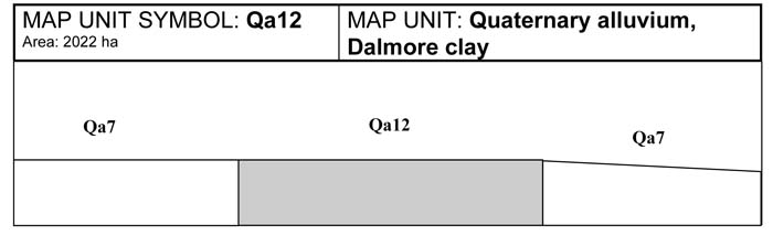
A. GENERAL DESCRIPTION
This map unit is part of the alluvial plains of the Koo-wee-rup Swamp. Dalmore clay has a peaty friable surface soil 20-30 cm in depth. This layer passes into a heavy black clay. As depth increases orange and pale grey mottles become evident. The organic self mulching nature of the topsoil allows for an easily worked friable seed bed. These soils are very valuable for horticultural purposes because of the friable top soil, inherent fertility and improved drainage provided by the organic topsoil and subsoil. If the soil is worked when wet smearing and compaction of the soil surface will occur, which is a result of the sodicity of the soil. The subsoil has a high shrink swell capacity and cracks when dry. This movement affects fences and structural foundations as they require a stable substrate.
SITE CHARACTERISTICS
| Parent Material Age: | Quaternary | Depth to Seas. Watertable: | > 1.5 m | |
| Parent Material Lithology: | Alluvium | Flooding Risk: | Low | |
| Landform Pattern: | Alluvial plain | Drainage: | Moderately well drained | |
| Landform Element: | Plain | Rock Outcrop: | Nil | |
| Slope a) common: | 1% | Depth to Hard Rock: | > 1.5 m | |
| Slope b) range: | 0-3% | |||
| Potential Recharge to Groundwater: | Low | |||
| Major Native Vegetation Species: | Melaleuca | |||
| Present Land Use: | Horticulture | |||
| Length of Growing Season: | 8 months | |||
LAND DEGRADATION
Degradation Processes | Water Erosion | Wind Erosion | Mass Movement | Salting | Acidification | |
sheet/rill | gully | |||||
Susceptibility | Very low | Low | Very low | Low | Moderate | Low |
Incidence | Very low | Very low | Very low | Very low | Low | NA |
B. SOIL PROFILE
PROFILE DESCRIPTION
| Site C9 | ||
A1 | 0-35 cm | Black (10YR5/1) peaty light clay, strong subangular blocky structure (self-mulching), peds 2-5 mm, rough fabric, strong consistence, pH 5.9. Clear transition to: |
B21 | 35-95 cm | Black (2.5Y2.5/0) heavy clay, strong lenticular structure, slickensides, peds 20-50 mm, smooth fabric, very strong consistence, pH 5.7. Gradual transition to: |
B22 | 95-150+ cm | Black (5Y2.5/1) heavy clay, moderate lenticular and prismatic structure, slickensides, peds 10-20 mm, smooth fabric, very strong consistence, pH 5.4. |
Classification
| Factual Key: | Ug5.1 |
| Australian Soil Classification: | Epihypersodic, Self-mulching, Black VERTOSOL; non-gravelly, medium fine/very fine, very deep (confidence level 2) |
| Unified Soil Group: | OH |
Interpretation of Laboratory ANAlysis*
Horizon | pH (CaCl2) | % Gravel | EC (salts) | Nutrient Status | P | K | Al | Organic Matter | Dispersibility |
A1 | 4.9 | < 2 | VL | VH | S | S | T | H | VL |
B21 | 4.8 | < 2 | VL | VH | S | S | T | H | M-H |
B22 | 4.7 | < 2 | VL | H | S | S | T | M | M-H |
T: Potentially Toxic NA: Not Available * see Appendix D for analytical results ** Strongly Acidic
Soil Profile Characteristics:
| Permeability: | Slow (average 23 mm/day, range 3-40 mm/day) |
| Available Water Capacity: | Very high (> 200 mm H2O) |
| Linear Shrinkage (B horizon): | Moderate (17%) |
C. LAND CAPABILITY ASSESSMENT
| Land Use | Class | Major Limiting Feature(s)/Land Use |
| Agriculture | C2T1S3 | Permeability-rainfall index |
| Effluent Disposal (septic tanks) | 4 | Permeability |
| Farm Dams | 5 | Suitability of subsoil |
| Building Foundations slab stumps/footings | 3 3 | Drainage Drainage, linear shrinkage |
| Secondary Roads | 5 | USG |
| Rural Residential Development | 5 | Farm dams, secondary roads |

© State of Victoria (Agriculture Victoria) 1996 - .

This work, Victorian Resources Online, is licensed under a Creative Commons Attribution 4.0 licence. You are free to re-use the work under that licence, on the condition that you credit the State of Victoria (Agriculture Victoria) as author, indicate if changes were made and comply with the other licence terms.
The licence does not apply to ‘branding’ or some ‘images or photographs’ that may be owned by third parties. We ask you to seek prior approval to use images using the VRO feedback form. Access to higher quality images can also be provided on request.
This page was last updated on .