
Mount Gisborne
|
This information has been obtained from the report: Eruption Points of the Newer Volcanic Province of Victoria by Neville Rosengren. This report was published in 1994 and was prepared for the National Trust of Australia (Victoria) and the Geological Society of Australia (Victorian Division). The review of eruption points was based on an earlier unpublished manuscript Catalogue of the post-Miocene volcanoes of Victoria compiled by O P Singleton and E B Joyce (Geology Department, University of Melbourne 1970). |
| 37 31 30S 144 35 00E (external link); 7822-4-4 (Toolern Vale) 865443. 4 km S of Gisborne. Mount Gisborne Road. |  Mount Gisborne | |
Gisborne. | ||
Public at summit and upper southern slope. Public walking access. Private land around base and on most of lava flows. Outcrop at and around summit on public land. | ||
Type 2: | Lava shield. | |
Mount Gisborne is the highest of the distinctive group of volcanic hills in the Gisborne-Sunbury area. It forms a broad, bulky lava dome with two final vents and a parasitic lava cone to the northeast (McGeorges Hill). There are two eruption points which have yielded the most complex suite of Newer Volcanics lavas known in Victoria, with the mineralogy and chemistry of early flows differing substantially from the younger flows. | ||
Four sequences of lavas are recognised: a) Initial radial valley flows of olivine oligoclase basalt, andesine basalt, limburgitic basalt and limburgite, separated by diatomaceous earth lenses, b) olivine hyperthene basalt then iddingsite basalt, c) hypersthene trachyandesite flows forming lava dome, and d) iddingsite basalt flows from final vents. | ||
641 m; 100 m. | ||
| State: | This volcano has a longer and more complex lava eruption sequence than any other Newer Volcanics eruption point. Three lava types are recognised at the eruption point and none of these occur together at any other eruption point in the state. It is an important site for petrological studies of eruption sequences. The site is public land and the summit affords an excellent view of other eruption points in the Gisborne-Sunbury region and for observing regional geological and geomorphological variation. | |
References: | Fenner, C. (1918). The physiography of the Werribee River area. Proceedings of the Royal Society of Victoria 31. pp. 176-313. Edwards, A.B. (1938). The Tertiary volcanic rocks of central Victoria. Quarterly Journal of the Geological Society of London 94, pp. 243-320. Edwards, A.B. & Crawford, W. (1940). The Cainozoic volcanic rocks of the Gisborne district, Victoria. Proceedings of the Royal Society of Victoria 52, pp. 281-311. Hills, E.S. (1940). The physiography of Victoria (1st edn.) Whitcombe & Tombs, Melbourne. | |
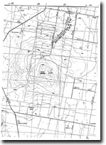 Mount Gisborne 7822-7-7 (Toolern Vale) | |

© State of Victoria (Agriculture Victoria) 1996 - .

This work, Victorian Resources Online, is licensed under a Creative Commons Attribution 4.0 licence. You are free to re-use the work under that licence, on the condition that you credit the State of Victoria (Agriculture Victoria) as author, indicate if changes were made and comply with the other licence terms.
The licence does not apply to ‘branding’ or some ‘images or photographs’ that may be owned by third parties. We ask you to seek prior approval to use images using the VRO feedback form. Access to higher quality images can also be provided on request.
This page was last updated on .