
Mount Cottrell
|
This information has been obtained from the report: Eruption Points of the Newer Volcanic Province of Victoria by Neville Rosengren. This report was published in 1994 and was prepared for the National Trust of Australia (Victoria) and the Geological Society of Australia (Victorian Division). The review of eruption points was based on an earlier unpublished manuscript Catalogue of the post-Miocene volcanoes of Victoria compiled by O P Singleton and E B Joyce (Geology Department, University of Melbourne 1970). |
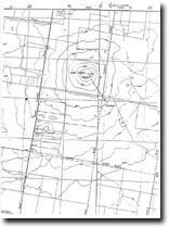
| Cottril | 37 46 00S 144 37 30E (external link); 7822-3-4 (Eyensbury) 907177. 4 lm SW of Rockbank. | 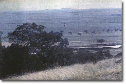 Mount Cottrell (broad rise on skyline) |
Mount Cottrell Road. | ||
Melton | ||
Private land. | Grazing, outcrop at summit. | |
Type 2 | Lava shield | |
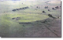
Mount Cottrell is a low lava cone resting on a broad lava shield formed by the radial eruption of numerous thin fluid lava tongues. The flows are symmetrically distributed around the vent producing an almost circular shield of considerable bulk although less than around 100 m in height. The massive nature of this mountain is best appreciated when viewed from a distant point such as the You Yangs. The slopes are of low angle apart from the summit area where a bluff of hard dense basalt 5 m high surrounds a shallow crater. The basalt dips in towards the crater with dips to 30o on the northern side. | ||
205 m; 60 m. | ||
State: | The site is significant in two aspects - the unusual structures at the bluff and crater and the extent of the radial flows, producing a very broad lava shield. This is the most massive of the Werribee Plains volcanoes and one of the largest shield volcanoes in Victoria. | |
References: | Coulson, A. (1938). The basalts of the Geelong district. Proceedings of the Royal Society of Victoria 53, pp. 394-402. Hills, E.S. (1940). The physiograpy of Victoria (1st edn). Whitcombe & Tombs, Melbourne. Condon, M.A. (1951). The geology of the lower Werribee River, Victoria. Proceedings of the Royal Society of Victoria 63, pp. 1-24. Ollier, C.D. & Joyce, E.B. (1964). Volcanic physiography of the Western Plains of Victoria. Proceedings of the Royal Society of V ictoria 77, pp. 357-376. Ollier , C.D. (1967a). Landforms of the Newer Volcanic Provicence of Victoria. In J.N. Jennings & J.A. Mabbutt (eds), Landform studies from Australia and New Guinea. ANU Press, pp. 315-339. Stewart, G. (1977). The Newer Volcanics lava field between Deer Park and the Werribee River. Geological Survey of Victoria Unpublished Report 1977/26. | |
 Mount Cottrell Summit | ||

© State of Victoria (Agriculture Victoria) 1996 - .

This work, Victorian Resources Online, is licensed under a Creative Commons Attribution 4.0 licence. You are free to re-use the work under that licence, on the condition that you credit the State of Victoria (Agriculture Victoria) as author, indicate if changes were made and comply with the other licence terms.
The licence does not apply to ‘branding’ or some ‘images or photographs’ that may be owned by third parties. We ask you to seek prior approval to use images using the VRO feedback form. Access to higher quality images can also be provided on request.
This page was last updated on .