
GP24
| Location: Fiveways | Aust. Soil Class: Endohypersodic, Epipedal, Aquic (and Black) VERTOSOL |
| Northcote Factual Key: Ug 5.16 | Great Soil Group: black earth |
| General Site Description: Pasture paddock. | Mapping Unit: Dalmore clay (heavy surface). |
| Landscape Description: Level plain. | Geology: Recent swamp deposits. |
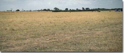 Site GP24 Landscape |
Surface soil:
| A1 | 0-20 cm | Black (10YR2/1); medium clay; strong coarse blocky, parting to moderate medium polyhedral structure; weakly self-mulching surface; rigid consistence dry; pH 6.1; clear change to: | 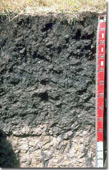 Site GP24 Profile |
| Subsoil: | |||
| B21 | 20-50 cm | Very dark grey (10YR3/1); medium heavy clay; strong very coarse blocky, parting to moderate coarse blocky (and moderate fine lenticular at depth) structure; slickensides present; rigid consistence dry; pH 7.1; clear change to: | |
| B22 | 50-90 cm | Dark grey (2.5Y4/0) with faint olive yellow (2.5Y6/6) diffuse mottles; medium heavy clay; moderate medium lenticular, parting to fine lenticular structure; slickensides present; very firm consistence moist; pH 7.5; clear change to: | |
| B31 | 90-130 cm | Light grey (10YR5/1) with brownish yellow (10YR6/8) mottles; medium clay; coarse lenticular structure; large slickensides present; firm consistence moist; contains occasional 'ironstone' (1-2 cm size) and manganese stains; pH 7.4. | |
- High clay content throughout profile.
- Vertic properties (ie. high shrink-swell capacity).
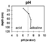
The surface soil is slightly acid. The subsoil
is slightly alkaline throughout.
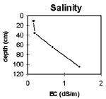
The salinity rating is very low for the upper
soil horizons. From 50 cm depth the rating
becomes low-medium. In the deeper soil profile
the rating becomes high.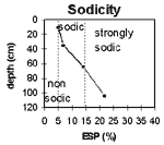
The surface soil is non-sodic. The upper
subsoil is sodic and the deeper subsoil
becomes strongly sodic.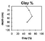
The clay content is high throughout the soil profile.
Horizon | Horizon Depth | pH water | pH CaCl2 | EC 1:5 | NaCI % | Exchangeable Cations | ExAl mg/kg | Ex Ac meg/100g | Field pF 2.5 | Wilting Point pF 4.2 | Coarse Sand (0.02 -0.2mm) | Fine Sand (0.02 -0.2mm) | Silt (0.02 -0.2mm) | Clay (<0.002mm) | |||
ca | mg | k | Na | ||||||||||||||
meg/100g | |||||||||||||||||
A1 | 0-20 | 6.1 | 5.4 | 0.15 | 15 | 16 | 0.65 | 1.5 | 57.1 | 35.1 | 10.8 | 14 | 11.5 | 48.5 | |||
B21 | 20-50 | 7.1 | 6.3 | 0.18 | 15 | 20 | 0.36 | 2.4 | 56.7 | 31.6 | 10.4 | 11.3 | 5.5 | 58 | |||
B22 | 50-80 | 7.5 | 6.9 | 0.67 | 0.13 | 14 | 21 | 0.33 | 5.5 | 58.2 | 30.5 | 10 | 11.3 | 6 | 68 | ||
B31 | 80-130 | 7.4 | 7 | 1.4 | 0.31 | 9.5 | 15 | 0.28 | 7 | 47.9 | 23.1 | 19.1 | 20.6 | 6 | 51.5 | ||
Management Considerations:
Note: This pit site occurs on a grassed verge (never cropped) beside a cropping paddock (see landscape photo on page 65). All samples were taken from this site apart from the surface horizon, which was sampled in the cropped paddock. This was done as the grassed verge site showed evidence of surface disturbance. Surface soil results will therefore more closely represent cropped conditions, but may still not be representative of the whole paddock, as the whole paddock was not sampled.
- Whole Profile
- Plant available water capacity (PAWC) is considered to be low (estimated at 90 mm). This is based on available laboratory data and assumes an effective rooting depth of 50 cm. Rooting depth will be restricted by the increase in soluble salts and sodicity in the deeper subsoil.
- Surface (A) Horizons
- When the soil is dry, heavy rains will move down soil cracks. This rapid recharge can be valuable for the survival of plants near wilting. When wet, the soil will swell and further infiltration of water will be relatively slow.
- The high wilting point value (ie. 35%) indicates that plants will be unable to utilise light rains when the soil is relatively dry.
- The surface soil will be difficult to manage, being hard and cloddy when dry and firm and sticky when wet. As a consequence, these soils are generally most suited to pasture production. Tillage or overstocking of cracking clay soils should be avoided if the soil is wet (ie. wetter than the plastic limit). At such moisture conditions excessive tillage, trafficking or overstocking can result in structural damage (eg. compaction, smearing) occurring. Ideally, tillage and trafficking should take place on clay soils when the soil is drier than the plastic limit, down to at least the depth of tillage.
- Subsoil (B) Horizons
- The deeper subsoil (from 50 cm depth) is sodic and disperses strongly. Root and water movement will be restricted as a result.
- The level of soluble salts becomes medium in the deeper subsoil (ie. at approximately 50 cm depth). From 90 cm depth the level becomes high. The growth of deeper rooted salt sensitive species will be restricted as a result.
- The subsoil displays strong vertic properties (indicated by the presence of deep cracking, slickensides and lenticular peds) which indicates that significant shrinking and swelling occurs during wetting and drying cycles. This may disturb the roots of some plant species and has engineering implications (eg. disturbance to building foundations and fence lines).
- Field crickets proliferate in soil cracks.

© State of Victoria (Agriculture Victoria) 1996 - .

This work, Victorian Resources Online, is licensed under a Creative Commons Attribution 4.0 licence. You are free to re-use the work under that licence, on the condition that you credit the State of Victoria (Agriculture Victoria) as author, indicate if changes were made and comply with the other licence terms.
The licence does not apply to ‘branding’ or some ‘images or photographs’ that may be owned by third parties. We ask you to seek prior approval to use images using the VRO feedback form. Access to higher quality images can also be provided on request.
This page was last updated on .