
GP21
| Location: Cranbourne. | Australian Soil Classification: Magnesic, Mottled-Subnatric, Grey SODOSOL |
| Northcote Factual Key: Dy 5.31 | Great Soil Group: soloth |
| Geology: Quaternary sands and sandy clays. | General Landscape Description: Lower lying area on a gently undulating sand plain. |
| Mapping Unit: Toomuc sandy loam. | Site Description: Grassed verge on the edge of a vegetable cropping paddock. |
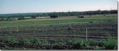 Site GP21 Landscape |
Soil Profile Morphology:
Surface Soil
| A1 | 0-20 cm | Dark greyish brown (10YR4/2); sandy loam; very weak consistence moist; weak crumb structure; pH 5.6; clear change to: | 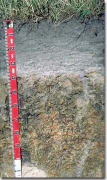 Site GP21 Profile |
| A2 | 20-35 cm | Greyish brown (10YR5/2); sporadically bleached loamy sand; weak consistence moist, firm to very firm dry; pH 5.7; sharp change to: | |
| Subsoil | |||
| B21 | 35-70 cm | Dark greyish brown (10YR4/2) with brownish yellow (10YR6/8) and yellowish brown (10YR5/8) mottles; medium heavy clay; strong medium prismatic, parting to strong coarse blocky structure; contains dark organic stains on ped faces; very strong consistence dry; pH 6.1; clear change to: | |
| B22 | 70-110 cm | Dark greyish brown (10YR4/2) with red (2.5YR4/8) and brownish yellow (10YR6/8) mottles; medium heavy clay; pH 6.4; clear and wavy change to: | |
| 2A | 110-140 cm | Brownish yellow (10YR6/6) sandy loam (clayey); structureless; contains patches of bleached sand and a few ironstone gravels (1-2 mm size); pH 7.1. |
Key Profile Features:
- Strong texture contrast between surface (A) horizons (10 % clay) and subsoil (B21) horizon (48 % clay).
- Dense and coarsely structured (prismatic) subsoil.
Soil Profile Characteristics:
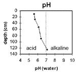 The surface soil is moderately acid. The subsoil becomes decreasingly acidic with increasing depth down the profile. | 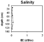 The salinity rating is very low throughout the soil profile. | ||
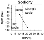 The upper subsoil is sodic and the profile becomes increasingly sodic with depth. | 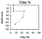 The clay content increases significantly at the A/B horizon interface. | ||
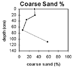 The coarse sand percentage decreases in the upper subsoil but increases again at depth in the buried soil. |
Horizon | Horizon Depth (cm) | pH water | pH CaCl2 | EC 1:5 | Exchangeable Cations | Field Capacity pF 2.5 | Wilting Point pF 4.2 | Coarse Sand (0.2 -2 mm) | Fine Sand (0.02-0.2 mm) | Silt (0.002-0.02 mm) | Clay (<0.002 mm) | |||
ca | mg | k | Na | |||||||||||
meq/100g | ||||||||||||||
A1 | 0-20 | 5.6 | 4.8 | 0.07 | 3.1 | 0.8 | 0.16 | 0.15 | 19 | 5.6 | 31.4 | 36.7 | 17 | 10.5 |
A2 | 20-35 | 5.7 | 4.6 | <0.05 | 0.87 | 0.58 | 0.09 | 0.13 | 12.7 | 3.2 | 32 | 38.4 | 20.5 | 10 |
B21 | 35-70 | 6.1 | 4.8 | 0.07 | 0.78 | 6.9 | 0.19 | 0.92 | 28.7 | 16.5 | 14.6 | 22.4 | 17 | 47.5 |
B22 | 70-110 | 6.4 | 5.1 | 0.09 | 0.42 | 6.4 | 0.14 | 1.3 | 30.5 | 15.1 | 7.4 | 35.5 | 18 | 43 |
2A | 110-140 | 7.1 | 5.5 | <0.05 | 0.16 | 2.6 | 0.07 | 0.72 | 11 | 5.4 | 57.7 | 23.4 | 2.5 | 16.5 |
Management Considerations:
Note: This pit site is on a grassed verge on the edge of a cropping paddock. Consequently, it will more likely represent uncropped conditions.
Whole Profile
- Plant available water capacity (PAWC) is considered to be very low (estimated at 40 mm). This is based on available laboratory data and assumes an effective rooting depth of 35 mm. Rooting depth will be limited by the dense and coarsely structured clay subsoil which is sodic and magnesic.
- The sporadically bleached A2 horizon indicates that periodic waterlogging occurs above the slowly permeable subsoil. When waterlogging occurs, the subsurface layer is likely to become ‘spewy’. Sub-surface drainage is often required.
- The surface soil has a low inherent fertility (based on the sum of the exchangeable basic cations). Organic matter is important for soils such as these with relatively low clay contents in order to enhance nutrient holding capacity. Levels of exchangeable potassium are relatively low in the surface horizons which may lead to a potash deficiency for plants. This can be assessed by plant tissue analysis.
- The surface soil is moderately acid and soil pH may need to be raised to meet preferred ranges for vegetable crops.
- The water holding capacity of the surface soil is low. Organic matter is important for these soils in order to enhance water-holding capacity. Organic matter additions will also improve soil aggregation and enhance root and water movement in the surface soil.
- The dense and coarsely structured upper subsoil is sodic and has a very low exchangeable calcium:magnesium ratio. This results in dispersion when the clay soil swells after wetting. Clay dispersion causes subsoil pores to become blocked and this results in restricted subsoil drainage. Root penetration will also be restricted.
- Nutrient imbalances (e.g. calcium, potassium deficiency) may occur in the subsoil as it is dominated by exchangeable magnesium. Nutrient deficiencies can be assessed by plant tissue analysis.
- The fine surface sands can compact and restrict water movement. To overcome this the soil is ploughed into the clay layer (45 cm or more) and turned upside down once per year. Gypsum is also added.
- Leeks and parsnips grown here.
- Soil variability across the paddock is high.
- Extensive drainage required to set up operation (storm water and agricultural drains and irrigation).

© State of Victoria (Agriculture Victoria) 1996 - .

This work, Victorian Resources Online, is licensed under a Creative Commons Attribution 4.0 licence. You are free to re-use the work under that licence, on the condition that you credit the State of Victoria (Agriculture Victoria) as author, indicate if changes were made and comply with the other licence terms.
The licence does not apply to ‘branding’ or some ‘images or photographs’ that may be owned by third parties. We ask you to seek prior approval to use images using the VRO feedback form. Access to higher quality images can also be provided on request.
This page was last updated on .