
Toomuc
Toomuc - Symbol: To
| This mapping unit comprises aeolian sediments over Tertiary sediments in the north-east part of the Mornington Peninsula. The soils may be regarded as a shallow version of Cranbourne sand, but the sands tend to be finer and the immediate subsoil is quite bleached. The surface soils of this unit are grey to dark grey loamy sands to sandy loams about 250 mm deep, overlying a bleached layer of similar texture. Mottled pale yellowish grey, grey and yellowish brown medium to heavy clays occur from about 600 mm depth. With increasing depth the clays may become sandier. The zone just above the clay generally contains ferruginous nodules (i.e. ‘buckshot’). The surface soils are naturally strongly acidic, pH 4.5 to 5.5 with the pH of the subsoils around 5.5 to 6.5. These soils can be referred to as Yellow or Grey Chromosols using the Australian Soil Classification, or Sodosols where the subsoil is sodic. Where soils of this mapping unit occur within or near the soils of the Cranbourne mapping unit some vegetables are grown. The soils are very prone to waterlogging, and the ‘spewy’ nature of the bleached zone when saturated makes cultivation difficult. Toomuc with Cranbourne - Symbol: To/Cr This mapping unit describes areas where about 15 to 35% of the area is comprised of sand deeper than 1metre. There are some areas where more or less intact vegetation remains and this is described as heathy woodland. | 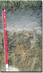 Example of Toomuc sandy loam soil near Cranbourne |

© State of Victoria (Agriculture Victoria) 1996 - .

This work, Victorian Resources Online, is licensed under a Creative Commons Attribution 4.0 licence. You are free to re-use the work under that licence, on the condition that you credit the State of Victoria (Agriculture Victoria) as author, indicate if changes were made and comply with the other licence terms.
The licence does not apply to ‘branding’ or some ‘images or photographs’ that may be owned by third parties. We ask you to seek prior approval to use images using the VRO feedback form. Access to higher quality images can also be provided on request.
This page was last updated on .