
Langwarrin
Langwarrin - Symbol: Lw
This mapping unit consists of rolling low hills and is formed either directly on Palaeozoic sediments or on material derived directly from these sediments.
The surface soils are generally grey or light grey loam to silty loams and about 150 mm deep. The soil surface is likely to set very hard. This overlies a paler grey to brownish grey similarly textured subsurface, often with iron concretions just above the subsoil clay. The subsoil occurs at about 400 mm to 500 mm and is generally a mottled light brownish grey and yellow-brown medium to heavy clay. On slopes, weathered rock occurs at a depth of about 1.0 to 1.5 metres. These soils are best described as Yellow or Brown Chromosols using the Australian Soil Classification. Where the rainfall is lower and the soils are exposed to more salt-laden rain, the subsoils may be sodic and the soils are likely to be Sodosols. Although these soils are well drained externally, their internal drainage is very slow because of the impermeable clay subsoil. During the wetter parts of the year, the subsurface becomes waterlogged. When wet, the surface soil tends to "run together" and sets hard on drying. Until fairly recently the soils were used for grazing, but increasingly they are being used for viticulture, particularly if the slopes are favourable. | 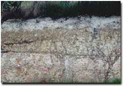 Langwarrin loam soil profile near Langwarrin |
On the Mornington Peninsula, some areas of the Langwarrin map unit which adjoin the Bittern map unit may include minor occurrences on the latter. This is because small areas of Palaeozoic sediments (Langwarrin) may be mantled later Tertiary sediments (Bittern).
Langwarrin, sand overlay - Symbol: Lw,s
One area of this mapping unit was mapped north-west of Woods Reserve, near Tuerong Junction. Here the underlying Palaeozoic sediments are mantled by a variable thickness of sand. The boundary of this unit was extrapolated from the geological map and aerial photographs and is therefore likely to be uncertain.
Langwarrin with Bittern - Symbol: Lw/Bi
As mentioned previously, the late Tertiary sediments mantle earlier rocks and sediments. Where the Tertiary sediments are shallow; it is often difficult to make decisions on the geology on which the soils have developed. In the case of this mapping unit, the Tertiary sediments partially overlay the Palaeozoic sediments, particularly on the higher and flatter parts of the landscape. This mapping unit delineates an area where about 10 to 35% of the area is covered by soils on Tertiary sediments.
On both the Tertiary sediments and the Palaeozoic sediments, texture contrast soils have developed, with a fine sandy clay loam or clay loam surface abruptly overlying a medium to heavy clay subsoil at about 300 to 400 mm. The soils on the Tertiary sediments (Bittern mapping unit) tend have sandier surface soils and have brighter coloured clay subsoils than those on the Palaeozoic sediments. The surface soils on the Palaeozoic sediments also tend to be siltier and the subsoil is drab coloured clay, with yellowish brown and pale grey colours predominating. It is likely that some of the clay subsoils will be sodic.
Both soils generally contain ferruginous nodules (‘buckshot’) above the clayey subsoil. In some cases the Palaeozoic sediments occur higher in the landscape, for example just west of Freeway near Moorooduc South, and in other cases the Palaeozoic sediments appears to be exposed near drainage lines (e.g. near Bulldog Creek road and Ellerina Road).
Most of the land within this mapping unit is used for grazing and large rural residential blocks. Where slopes are favourable, viticulture is an increasing option. The main constraints to viticulture are shallow surface soils, sodic subsoils and the potential for subsoil waterlogging during wetter periods. Substantial remnants of lowland forest remain west of Bulldog Creek road.

© State of Victoria (Agriculture Victoria) 1996 - .

This work, Victorian Resources Online, is licensed under a Creative Commons Attribution 4.0 licence. You are free to re-use the work under that licence, on the condition that you credit the State of Victoria (Agriculture Victoria) as author, indicate if changes were made and comply with the other licence terms.
The licence does not apply to ‘branding’ or some ‘images or photographs’ that may be owned by third parties. We ask you to seek prior approval to use images using the VRO feedback form. Access to higher quality images can also be provided on request.
This page was last updated on .