
Flinders
Flinders - Symbol: Fl
Much of the area immediately north of Flinders is mapped as this unit. All of the soils overlie Tertiary basalts. The original vegetation was grassy woodland, but where it occurs with the Flinders clay mapping unit closer to coast, fewer trees were present. Adjoining the coast, the vegetation was a mosaic of coastal headland scrub and coastal tussock grass. Minor areas within the central part of the Peninsula supported herb-rich foothill forest. Although most of the soils of this mapping unit carry improved pastures, some occurrences within the Red Hill area are used for viticulture and orchards, as are the generally more productive soils of the Red Hill mapping unit. | 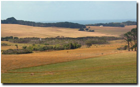 Rolling low hills in the Flinders mapping unit |
Most of the surface soils are dark brownish grey clay loams or very fine sandy clay loams. At about 200 mm depth, a bleached zone occur, generally with some iron oxide concretions (i.e. ‘buckshot’). Mottled greyish brown and yellowish brown medium to heavy clays occur abruptly at about 300 to 400 mm. These clays become mottled with strong brown to reddish brown colours with depth and usually continue to deeper than 2 metres before rock is encountered.
In some cases, the change from a clay loam surface soil to medium or heavy clay subsoil is less abrupt, and the changes in soil texture down the soil profile are more gradual.
Flinders clay - Symbol: Fl,c
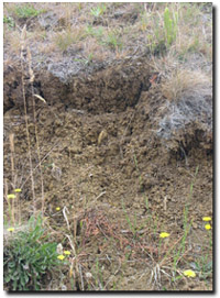 Brown Vertosol ("Flinders Clay") | Some areas adjoining the coastline just west and north of Flinders have strongly structured dark grey to dark brown medium clay surface soils. These are denoted by the symbol “Fc”. The underlying decomposing basalt is frequently encountered before 1.8 metres depth. Heavy clays occur from about 300 mm and are dominantly grey, but may be mottled with yellowish brown. Where the surface soils are dark brown, strong brown colours occur down to the underlying ecomposing rock. Although areas comprising only Flinders clay occur along the southern coastline, where they supported a mosaic of coastal headland scrub and coastal tussock grass, they have been mapped as a complex mapping unit called Flinders and Flinders clay (Fl:Fl,c). Most of the area is used for grazing. Flinders, sand overlay - Symbol: Fl,s Small areas of this mapping unit occur within the sandy southern parts of the Mornington Peninsula west of Main Creek. Here the underlying basalt is mantled by a variable thickness of sand. The boundaries of this unit were extrapolated from the geological map and aerial photographs - and are likely to be uncertain. As the areas are small, the land use would be similar to the surrounding area. |
Flinders with Red Hill - Symbol: Fl/Rh
This mapping unit describes areas where about 15 to 35% are soils typical of the Red Hill mapping unit, which is described later, and the remainder are typical of the Flinders unit. The Red Hill soils are the friable, “red” and porous soils favoured for intensive agriculture on the Peninsula. The soils of this mapping unit are all developed on Tertiary basalts.
Flinders and Flinders clay - Symbol: Fl:Fl,c
As mentioned previously, some areas which adjoin the coastline just west and north of Flinders have strongly structured dark grey to dark brown medium clay surface soils denoted by the symbol “Fl,c”. Heavy clays occur from about 300 mm depth and are dominantly grey but may be mottled with yellowish brown. Where the surface soils are dark brown, strong brown colours occur down to the underlying decomposing rock. The underlying decomposing basalt is frequently encountered before 1.8 metres depth. Other areas, somewhere between 35 and 70%, are more typical of the soils described under the Flinders mapping unit.
The Flinders and Flinders clay mapping unit describes an area where between 35 to 70% of the soil is either Flinders or Flinders clay. Originally the area was grassy woodland with less trees occurring towards the coastline. Adjoining the coastline there was a mosaic of coastal headland scrub and coastal tussock grass. The vegetation in the incised drainage lines was swamp scrub, predominantly swamp paperbark. Most of the area is used for grazing.

© State of Victoria (Agriculture Victoria) 1996 - .

This work, Victorian Resources Online, is licensed under a Creative Commons Attribution 4.0 licence. You are free to re-use the work under that licence, on the condition that you credit the State of Victoria (Agriculture Victoria) as author, indicate if changes were made and comply with the other licence terms.
The licence does not apply to ‘branding’ or some ‘images or photographs’ that may be owned by third parties. We ask you to seek prior approval to use images using the VRO feedback form. Access to higher quality images can also be provided on request.
This page was last updated on .