
L12 - Bacchus Marsh Basin
|
This information has been developed from this publication:
|
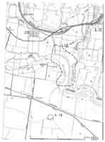
| Location: | Lerderderg - 782248. Shire of Bacchus Marsh. Valley of Werribee River, 4 km southeast of Bacchus Marsh. | |
Access: | Whelans Lane. | |
Ownership: | Private land. | |
Site Description: | The site includes the south-eastern part of the Bacchus Marsh basin. This basin is the alluvial floodplain of the Werribee and Lerderderg Rivers and is of complex origin. It is bounded to the north, east and south by lava flows, and to the west by the Rowsley Fault scarp. In part, the basin is due to erosion by the streams, but it is largely a structural feature caused by convergence of lava flows and by faulting. The Werribee River crosses the basin, exiting at the southeastern corner through a deep and narrow gorge eroded into the basalt of the Bullengarook lava flow. The upper part of this gorge has been filled by the storage back-up from the Melton Reservoir, and at full capacity water floods a part of this site. The floodplain displays point bar deposits and old channels of the Werribee River immediately upstream of the gorge. In the steep valley walls of both sides of the gorge, there are outcrops of sand and gravels interbedded in the lava flows. | |
Significance: | Regional. The Bacchus Marsh basin is one of the largest areas of alluvial terrain in the study area. It has long drawn the attention of geologists and provides challenging problems in interpretation of geomorphological history. While the gross form of the basin is unchanged by land use, the details of channel features and surficial geology have been greatly modified on the floodplain by intensive agriculture. This site has been selected to illustrate the major characteristics of the valley floor and lava flow slopes that surround much of the basin. | |
Management: | Class 2. Because of the hazard of flooding, building should not be permitted on the floodplain. Dredging or sand extraction would destroy the sensitive floodplain channel and bar morphology. The valley side slopes could be retained in agricultural land use to maintain site significance. | |
References: | Fenner C (1918, 1925) Singleton OP (1967) Roberts P (1984) | |

© State of Victoria (Agriculture Victoria) 1996 - .

This work, Victorian Resources Online, is licensed under a Creative Commons Attribution 4.0 licence. You are free to re-use the work under that licence, on the condition that you credit the State of Victoria (Agriculture Victoria) as author, indicate if changes were made and comply with the other licence terms.
The licence does not apply to ‘branding’ or some ‘images or photographs’ that may be owned by third parties. We ask you to seek prior approval to use images using the VRO feedback form. Access to higher quality images can also be provided on request.
This page was last updated on .