
L11 - Anthony's Cutting - Volcanics and Sediments
|
This information has been developed from this publication:
|
| Location: | Lerderderg - 794264. Shire of Bacchus Marsh. Road cutting on southern side of Western Freeway, 5.5 km east of Bacchus Marsh. | 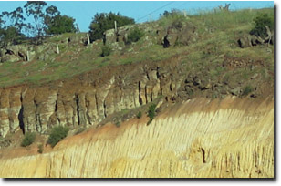 Anthony's Cutting |
Access: | Western Freeway. | |
Ownership: | Crown land. | |
Site Description: | The cutting on the southern side of the Western Freeway reveals an important section into lava flows from Mount Bullengarook and Tertiary and Quaternary sediments. Flows of strongly jointed basalt outcrop at road level at the Melbourne end of the cutting and these are overlain by a 15 m thick deposit of cross-bedded non-marine Pleistocene sands and gravels. One hundred meters along the cutting (towards Bacchus Marsh), sandy clays, sands and gravels of the middle Tertiary Werribee Formation that underlies the Bullengarook lava flow are exposed at road level and the lavas are 10 to 15 m above road level. At the top of the Werribee Formation (beneath the lava flow) is a reddish zone in the sediments that is the weathering horizon and soil of the pre-basaltic land surface. It is therefore an example of palaeosol. Several types of jointing and weathering occur in the volcanics. | |
Significance: | State. The site is an outstanding display of the relationship between the Bullengarook lava flow and various Tertiary and quaternary sedimentary formations in the Bacchus Marsh district. It is widely used as a teaching site in earth science courses to demonstrate principles of stratigraphy, structure and regional geology. | |
Management: | Class 1. The cuttings are clear and generally un-structured by weathered accumulations, vegetation or artificial structures. The proximity to the highway precludes close observation but they can be clearly observed from the top of the opposite cutting. Provision of off-road parking at the top of the cutting on the northern or western side would allow safer access to viewing points. It is important that the road management authorities consult with geologists if change to the road alignment is planned. No attempts should be made to artificially stabilise the cuttings. | |
References: | Singleton OPS (1973) Joyce EB and King RL (1980) Roberts PS (in press) | |
 Site - L11 |

© State of Victoria (Agriculture Victoria) 1996 - .

This work, Victorian Resources Online, is licensed under a Creative Commons Attribution 4.0 licence. You are free to re-use the work under that licence, on the condition that you credit the State of Victoria (Agriculture Victoria) as author, indicate if changes were made and comply with the other licence terms.
The licence does not apply to ‘branding’ or some ‘images or photographs’ that may be owned by third parties. We ask you to seek prior approval to use images using the VRO feedback form. Access to higher quality images can also be provided on request.
This page was last updated on .