
PP76. Fossil Beach, Mornington - Stratigraphy and Palaeontology
|
This information has been developed from one or more of these publications:
|
| Location: | 273652. Coastal cliffs, platforms and reefs from Marina Cove south including Fossil Beach and Dava Beach, 3 km south of Mornington. | 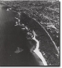 Site 76. Marina Cove (A), Fossil Beach (B), Dava Beach (C). Arrows show important shore platform beds of Balcombe Clay. |
Access: | From parking area off the Esplanade, 200 m north of Bentons Road. Walk along fire access track to picnic area. | |
Ownership/Managing Authority: | Crown land, Shire of Mornington. | |
Site Description: | The site exposes several units of the Tertiary marine transgressive-regressive sequence of the Mornington district. The area is extensively landslipped with unstable cliffs partly protected by masonry and boulder walls. The exposures available to earlier workers have been degraded in recent years due to landslips, revegetation, coastal protection works and over-zealous fossil collection by enthusiastic amateurs and excursion groups. The site includes all the units from the Older Volcanic basalt to the Baxter Sandstones and displays the complete sequence beginning with volcanics and non-marine sediments, passing to marine and then returning to non-marine conditions. At the south end of Fossil Beach (about 100 m south of the end of the sea wall), the Fossil Beach Fault exposes the Mt Martha Sand Beds and the Harmon Rocks Sand Bed which are not visible north of the fault. These are best seen in cliff sections behind and south of Dava Beach. Of particular significance is the Balcombe Clay which is exposed in the low cliffs north of the sea wall and on the intertidal platform at Fossil Beach. This is a complex geological unit and is important in the study of stratigraphy, palaeontology, mineralogy and weathering. This formation has two units, (calcareous and non-calcareous), the former being a richly fossiliferous clayey silt with bands of hard carbonate concretions of uncertain origin. These concretions are lenticular in form and vary from a few centimeters to almost a metre in length. They contain about 80% carbonate, and in the 1860’s a plant was built at the site to extract and process these as a source of lime for cement making – (the beach was formerly known as Cement Beach). Remains of the kiln are visible near the picnic area (by the toilet block) at Fossil Beach. There are now few accessible concretion layers in the cliffs but they occur in the intertidal area. | |
The calcareous Balcombe Clay beds have an abundant fossil fauna, the richest layer containing the most robust shells being a 7 cm bed exposed only at low tide, although fossils also occur above and below this layer. In the cliffs, the fossils are scarcer and are more fragile. The fauna is dominated by mollusc (bivalves and gastropods), foraminifera and other microfossils, but includes sponge spicules, corals, echinoids and the ‘ear bones’ (otoliths) of fish. The latter are of particular importance in the systematic study and taxonomy of fossil fish. | ||
Significance: | National. The site is the type locality for the Balcombian Stage, a major sub-division of the Tertiary in Australia. It was first defined here by Hall and Pritchard (1902) and subsequently re-defined by Singleton (1941) as comprising 22 m of the calcareous clays at Fossil Beach (about half this is sub-surface). It is therefore a nationally important site in Australian Tertiary stratigraphic studies. It includes the type locality of the Marina Cove Sand and the Balcombe Clay and is a major site to show changing depositional conditions. The conformable contact of the Baxter Sandstone overlying the Marina Cover Sand is best exposed here. Fossil Beach has long been recognised as a major fossil site and despite the degradation and reduction of exposures, still yields important material. The site therefore provides challenging problems in geological mapping and interpretation. | |
Management Considerations: | Class 1. The site should be managed as a geological reserve rather than a general public recreation area. To this end, casual use should be discouraged to avoid unnecessary degradation of outcrops by trampling or climbing, and the need to provide facilities. Coastal protection and cliff stabilization works have reduced the outcrop area available for sampling and fossil search. It is important to recognise that the most significant exposures of the Balcombe Clay occur on the shoreline and intertidal area. Further coastal protection works or other foreshore or offshore works, (including vegetation management, drainage, access) should be designed only in consultation with geological groups with specialist knowledge of the site. | |
References: | Hall, T.S. & Pritchard, G. B. (1901). Some section illustrating the geological structure of the country about Mornington. Proc. R. Soc. Vict., 14, 32-54. Singleton, F.A. (1941). The Tertiary geology of Australia. Proc. R. Soc. Vict., 53, 1-125. Carter, A.N. (1959). Guide to Foraminifera of the Tertiary stages in Victoria. Min. geol. J. Vict. 6 (3), 48-54. Davies, E.M. (1960). Balcombe Bay - a classic area for Victorian geology. Vic. Nat., 77, 14-18. Gostin, V.A. (1966). Tertiary stratigraphy of the Mornington district, Victoria. Proc. R. Soc. Vict., 79, 459-512. | |
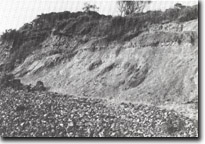 Site 76. Degraded cliffs of Balcombe Clay | |
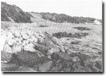 Site 76. Boulder wall covering shore platform outcrops, Fosters Slip north of Fossil Beach. |

© State of Victoria (Agriculture Victoria) 1996 - .

This work, Victorian Resources Online, is licensed under a Creative Commons Attribution 4.0 licence. You are free to re-use the work under that licence, on the condition that you credit the State of Victoria (Agriculture Victoria) as author, indicate if changes were made and comply with the other licence terms.
The licence does not apply to ‘branding’ or some ‘images or photographs’ that may be owned by third parties. We ask you to seek prior approval to use images using the VRO feedback form. Access to higher quality images can also be provided on request.
This page was last updated on .