
170. Cape Woolamai - Granite Tombolo
|
This information has been developed from one or more of these publications:
|
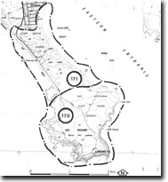
| Location: | Woolamai – 565305 to 565298. The site includes all the area of Cape Woolamai above low water mark. | 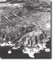 High granitic cliffs and dune covered plateau of Cape Woolamai. Arrows show dune ridges aligned along joint planes in the granite. Note the deep clefts in the cliffs and the boulder beaches, Site 170. |
Access: | Woolamai Beach Road and foot track from the car park at the surf lifesaving club. | |
Ownership: | Crown land. | |
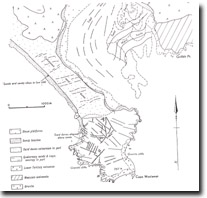
Geology/Geomorphology: | Cape Woolamai is part of a tombolo system that includes the predominantly granitic mass of the cape and the complex of volcanic rocks,. Sediments, beach material and dunes that links the granite with the main body of Phillip Island. Woolamai Hill (112 m) is the highest point on Phillip Island and the surface of the cape slopes gradually towards the north at an average angle of 5o (Edwards 1945). The main body of Cape Woolamai is a small stock of pink, coarse, porphyritic, potassium rich material known as the Cape Woolamai Granite (Tattam, 1976). The rock is well exposed in coastal cliffs and on the south-western coast, eg at the Pinnacles, these cliffs are of spectacular form and dimension. Strong jointing has determined the orientation of gutters and deep clefts that have been eroded in the cliff face and base, and produced the pyramidal rock stacks and large boulders that are typical of the exposed southern coastlines. The shoreline is also notable for the lack of horizontal platform development (Edwards 1942, 1945). The northern coastline facing the Eastern Entrance is more subdued in form and here a small disused quarry provides accessible exposures of the granite materials. | |
The upland surface of Cape Woolamai is covered by calcareous and quartzose sands and occasional patches of dune calcarenite. The sands are aligned in parabolic formations and parallel intersecting sets that differ considerably in their orientation from that to be expected by analysis of present wind regimes (Teh 1973). Jenkin (1962) explained the parallel sets are related to jointing in the granite and Teh (1973) suggested that the burrowing habit of Mutton Birds (Puffinus tenuirostris) has in part determined the orientation of the older parabolic dunes. | ||
Significance: | National. Cape Woolamai is a very distinctive landform and a class example of a former island now linked to a larger land mass to form a tombolo system. The granite cliffs are amongst the highest on the Victorian coast and the diverse array of storm environment features on the southern coast contrast markedly with those of the sheltered Eastern Passage shore. The upland dune features are unique in Victoria and provide an unusual example on a national scale of the multiple processes that shape dune sands. | |
Management: | Class 1. Continuation of the present management policies as a State Faunal Reserve is consistent with maintaining the national significance rating of the site. It is emphasised that motor vehicles must be completely prohibited from the area and no exotic plant species should be introduced into the dune sands. Extraction of dune sands should be prohibited. | |
References: | Edwards, A.B. (1942). The San Remo peninsula. Ibid. 54 (1), 59-78. Edwards, A.B. (1945). The geology of Phillip Island. Ibid. 57 (1+2), 1-21. Jenkin, J.J. (1962). The geology and hydrogeology of the Westernport area. Dept. of Mines, Vict., Underground Water Investigation Report. No. 4. Teh, Tiong Sa. (1970). Cape Woolamai Faunal Reserve: a study of the physical geography and ecology as a basis for conservation management. M.Sc. (unpub.), Geog. Dept., Univ. Of Melb. Teh, Tiong Sa (1973). Geology of parabolic dunes at Cape Woolamai, Victoria, Aust. Ilmu Alam, Bil. 2. Tattam (1976). | |

© State of Victoria (Agriculture Victoria) 1996 - .

This work, Victorian Resources Online, is licensed under a Creative Commons Attribution 4.0 licence. You are free to re-use the work under that licence, on the condition that you credit the State of Victoria (Agriculture Victoria) as author, indicate if changes were made and comply with the other licence terms.
The licence does not apply to ‘branding’ or some ‘images or photographs’ that may be owned by third parties. We ask you to seek prior approval to use images using the VRO feedback form. Access to higher quality images can also be provided on request.
This page was last updated on .