
LP19
DRAFT PROFILE ONLY | |
| Location: Pyramid Hill | Australian Soil Classification: |
| Northcote Factual Key: | Great Soil Group: |
| General Landscape Description: Treeless plain landscape unit near Pyramid Hill. | |
| Local Name: This soil corresponds to Mologa Loam as described by Skene (1971). It normally occupies low rises and plains adjoining prior stream levees. | |
Soil Profile Morphology
Surface Soil
| A1 | 0-1 cm | Brown (7.5YR4/4); loam; hardsetting surface condition; weak consistence dry; pH 5.7; sharp and smooth change to: | |
| A2 | 1-10 cm | Brown (7.5YR4/4) with a sporadic bleach (7.5YR7/4d); light fine sandy clay loam; massive in structure; strong consistence dry; pH 6.1; sharp and smooth change to: | |
Subsoil | |||
| B21 | 10-30 cm | Red (2.5YR4/6); medium heavy clay; moderate prismatic, breaking down to medium blocky structure; strong consistence dry; at 10-15 cm depth there are many (20%) iron stains (around root channels and ped faces); pH 7.8; clear and smooth change to: | |
| B22 | 30-50 cm | Yellowish red (5YR5/8); medium clay; moderate prismatic, breaking down to medium blocky structure; weak consistence moist; contains very few (<2%) iron stains; pH 8.4; clear and smooth change to: | |
| B23 | 50-70 cm | Reddish yellow (7.5YR6/6) with red (2.5YR4/6) mottles; light medium clay; moderate prismatic, breaking down to strong coarse polyhedral structure; firm consistence moist; at 50-55 cm depth there are nests of fine gypsum crystals and a few (5%) gypsum crystals (1-2 mm in size); pH 8.3; gradual change to: | |
| B24 | 70+ cm | ellowish brown (10YR5/4) with red (2.5YR4/6) mottles; medium heavy clay; strong coarse polyhedral structure; weak consistence moist; contains a few (5%) dark soft veins; pH 8.5. | |
Key Profile Features
- Hardsetting surface condition.
- Strong texture contrast between surface (A1) horizon and subsoil (B21) horizon.
- Accumulation of gypsum crystals in the subsoil (B23).
Key Profile Characteristics
 |
Management Considerations:
Whole Profile
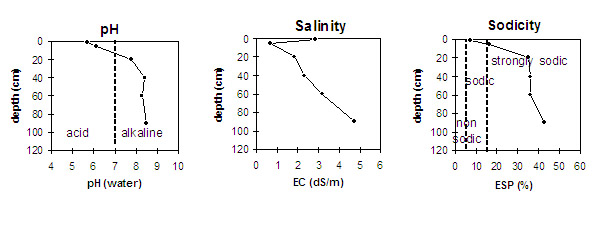
- Plant available water capacity (PAWC) is likely to be relatively low due to the high level of soluble salts throughout the profile. Effective rooting depth is also likely to be restricted by the sodic subsurface and subsoil horizons.
- The profile is extremely saline and is likely to restrict the growth of salt sensitive plant species (e.g. faba beans, linseed, chickpeas and lupins).
- A positive feature of this profile is that it has a moderate inherent fertility throughout which is beneficial to plant growth.
Surface (A) Horizons
- The shallow loam surface (A1) has a high organic carbon content and a moderate nitrogen level (this may or may not be representative of the whole paddock). Organic matter is important for promoting soil aggregation as well as giving the soil a high cation exchange capacity. These high levels should be maintained to protect against erosion and for plant growth, as major soil reserves of nitrogen, sulphur and phosphorus are usually present in organic matter.
- The surface (A1) horizon is also sodic with no dispersion due to the very high salt levels.
- The subsurface (A2) horizon is hardsetting when dry and has a high fine sand content. When cultivated dry, the soil will become “powdery” and the structure will break down. This horizon is strongly sodic and disperses in water. Water and plant root movement is likely to be restricted by these conditions. Also, cultivation of such soils when wet will result in further structural degradation (e.g. hard pan development).
- The presence of sporadic bleaching in the subsurface (A2) horizon indicates that periodic waterlogging occurs above the slowly permeable subsoil. This bleached horizon also has a low inherent fertility.
Subsoil (B) Horizons
- The densely and coarsely structured upper subsoil (B21) is strongly sodic at 10 cm depth with a low exchangeable calcium to magnesium ratio (0.5) and becomes extremely sodic at 35 cm. The extremely high salinity level has probably contributed to the lack of dispersion and thus root and water movement should not be significantly restricted. Nevertheless, subsoil permeability will be low due to the low porosity of the clayey horizons. Restricted drainage is indicated by the presence of iron staining at the top of the subsoil.
Comments from Gyn Jones:
- This soil is associated with prior stream activity and is similar to Aligah Loam.
- It is thought that since the site was naturally a treeless plain that the area was always salty. Once saline it is very hard to reverse as the subsoil is impermeable and the sodium can not leach out of the system.
Evidence of this is the ironstone sitting on a hard pan surface at 10 cm depth, indiacting that water can not pass through. Although the soil is saline it will support a perrenial pasture as long as rainfall is plentifull. - The obvious treatment would be to apply gypsum but the soil is impossible to plough making it impossible for the gypsum to get into the profile. Even roots were found no deeper that 25 mm. Accordingly, there is no cropping potential on this soil type.
© State of Victoria (Agriculture Victoria) 1996 - .

This work, Victorian Resources Online, is licensed under a Creative Commons Attribution 4.0 licence. You are free to re-use the work under that licence, on the condition that you credit the State of Victoria (Agriculture Victoria) as author, indicate if changes were made and comply with the other licence terms.
The licence does not apply to ‘branding’ or some ‘images or photographs’ that may be owned by third parties. We ask you to seek prior approval to use images using the VRO feedback form. Access to higher quality images can also be provided on request.
This page was last updated on .