
LP118
| Group: Bendigo Creek Floodplain Group | Australian Soil Classification: Hypocalcic, Mesonatric, Brown SODOSOL |
| Northcote Factual Key: Db 2.43 | Great Soil Group: solodic |
| General Landscape Description: Level plain near drainage depression. | Geology: Alluvial deposits (Quaternary). Coonambidgal formation. |
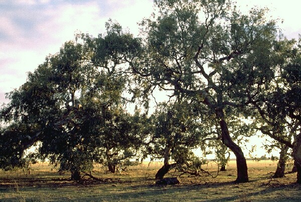 LP118 Landscape |
Soil Profile Morphology
Surface Soil
| A1 | 0-7 cm | Dark brown (10YR3/3), sandy loam; firm consistence when dry; few (<2%) ferruginous gravels; pH 6.2; clear change to: | 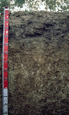 LP118 Profile |
| A2e | 7-15 cm | Dark brown (10YR4/3) conspicuously bleached (10YR7/3d), fine sandy clay loam; strong consistence when moderately moist; few (5%) ferruginous gravels; most roots stop in the 10-15 cm zone; pH 6.7; gradual change to: | |
| Subsoil | |||
| B21 | 15-40 cm | Dark brown (10YR3/3), light clay; moderate coarse blocky structure; very strong consistence when moderately moist; few roots (probably tree) reach 40 cm; pH 8.3; gradual change to: | |
| B22 | 40-70 cm | Yellowish brown (10YR5/6) with yellowish brown (10YR5/4) mottle, light clay; moderate coarse polyhedral structure, breaking to strong fine polyhedral structure; strong consistence when moderately moist; few (2%) hard carbonate nodules; pH 9.5; clear change to: | |
| B23 | 70-110 cm | Reddish brown (5YR4/4) and yellowish brown (10YR5/6), light clay; strong medium sized polyhedral structure, breaking to moderate very fine polyhedral structure; very firm consistence when moderately moist; carbonates (hard in tubules and soft in patches) common (15%); pH 9.7; gradual change to: | |
| B24 | 110-140 cm | Yellowish brown (10YR5/6) and reddish brown (5YR5/4), clay loam; strong medium sized polyhedral structure, breaking to moderate very fine polyhedral structure; strong consistence when moderately moist; very few (< 2%) carbonate nodules; pH 9.5; gradual change to: | |
| B25 | 140-170 cm | Dark brown (7.5YR4/4) and light yellowish brown (10YR64), light clay, with 10% sand in pockets (10YR5/8 and 10YR5/4); weak coarse prismatic structure, breaking to moderate medium sized polyhedral structure; strong consistence when moderately moist; few (5%) manganese stains; pH 9.6; clear and tongued change to: | |
| B26 | 170-190 cm | Dark yellowish brown (10YR4/6) and yellowish brown (10YR5/8 and 10YR5/4), fine sandy clay loam; very firm consistence when moderately moist, pH 9.1. | |
Key Profile Features
- Strong texture contrast between surface (A) horizons and subsoil (B) horizons.
- Conspicuously bleached subsurface (A2) horizon.
Key Profile Characteristics
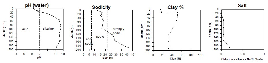
pH | Salinity Rating | |||
Surface (A1 horizon) | slightly acid | very low | sodic | slight1 |
Subsoil (B21 horizon) | moderately alkaline | low | strongly sodic | complete |
Deeper subsoil (at 110 cm) | extremely alkaline | low (medium at 170 cm) | strongly sodic | complete |
| 1 Strong when remoulded. | ||||
 |
Management Considerations:
Surface (A) Horizons
- Organic carbon levels indicate that organic matter content is relatively low for the surface soil from this pit. Organic matter is important for enhancing soil aggregation, fertility and water holding capacity on soils such as these with high fine sand content. Organic matter levels will build up under pasture but will decline if cultivation takes place. Practices such as residue retention, minimum tillage and including pasture rotations should be utilised if cropping occurs.
- The surface horizons have a low inherent fertility (based on the sum of the basic exchangeable cations).
- The bleached subsurface (A2) horizon indicates that periodic waterlogging occurs on top of the more slowly permeable subsoil. This horizon is likely to become 'spewy' as a result.
- The surface horizon is dispersive, especially when disturbed in a moist condition. This will reduce permeability so water will remain on the surface. This condition may be ameliorated with the application of gypsum. Test strips should be trialed to assess the likely benefits.
Subsoil (B) Horizons
- The deeper subsoil (from 40 cm depth) is strongly alkaline which indicates that some nutrients (eg. copper, iron, manganese, and zinc) may be poorly available to deeper rooted plants.
- The subsoil is sodic and dispersive which will result in restricted root and water movement in the soil. Water is likely to build up in the surface horizons (as they are more porous) after heavy rains causing waterlogging and surface runoff.
- The deep subsoil (below 140 cm) is slightly saline and is moderately saline below 170 cm.
Other comments:
- Short distance from site of old sand pit (now filled with water).
- River red gums (Eucalyptus camaldulensis) are the most common tree.
Notes
- Profile described by Paul Rampant and Ruth Lourey (22/5/96)
© State of Victoria (Agriculture Victoria) 1996 - .

This work, Victorian Resources Online, is licensed under a Creative Commons Attribution 4.0 licence. You are free to re-use the work under that licence, on the condition that you credit the State of Victoria (Agriculture Victoria) as author, indicate if changes were made and comply with the other licence terms.
The licence does not apply to ‘branding’ or some ‘images or photographs’ that may be owned by third parties. We ask you to seek prior approval to use images using the VRO feedback form. Access to higher quality images can also be provided on request.
This page was last updated on .