
Site 10: Salt Scalds, Jones Road (issue: discharge)
Back to Bet Bet Creek Catchment Homepage
Landscape
After turning off the Blackbottom Road and heading west for 2.5 km, you will arrive in an area not unlike a moonscape. The land is bare, and it seems to have a concrete-like crust and very little if anything can grow on it. This is saline discharge at its most severe.
To your right (north) is the dividing range about 1 km away. It is within this short distance that sufficient water has been able to recharge and pick up salt to do the damage you see before you. The cleared portion of this country above us was originally forested in a similar way to the roadside, and since clearing, water use has been reduced dramatically, giving rise to the discharge we now see before us. Journey to the corner and up the road to your right for a complete view of the site.
Issues
1. Recharge. Lack of perennial vegetation on the cleared areas has resulted in high recharge of water through the soil.
2. Discharge. Once in the ground, salts are easily picked up and discharged lower down the slope.
3. Road damage. Salt doesn’t only affect living things - the high water table and high salt concentration causes the road base to become unstable leading to its deterioration.
Long Term Objectives
With such a major task ahead of us it is very important to concentrate on the causes (i.e. recharge) and not the effects (i.e. the discharge). Tree planting on the ridge tops should be planned and supported by pasture works on all the slopes above and around the discharge area. Next, work on the discharge site itself can commence. It must initially be fenced out so that it can be managed separately from the surrounding unaffected land.
Where soil is badly crusted, deep ripping will break this - allowing rain to enter and flush salt away from the surface. In addition, planting of salt tolerant grasses (e.g. tall wheat grass, phalaris) can commence. Successful establishment will lead to surface protection from evaporation and water use by the plants that will keep the salty water away from the soil surface. This will enable a gradual rebuilding of soil structure and fertility.
The longer-term plan for this site is to reduce recharge above the site and to stop the discharge site from expanding.
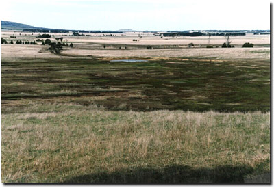
Notes from the Photo
This photo was taken from around the corner looking back to the South. The hills in the background are where the recharge is occurring and creating the salinity in the foreground.
Vegetation is a good indication as to how salty the area is. Bare areas have higher salt levels that have killed all plant life. Some plants have a high tolerance to salting but are non-productive in an agricultural sense.
The level plain that stretches away from us is a productive sedimentary plain. Because of the saline discharge (caused by poor water use) the groundwater in this flat land is rising toward the surface and may now be within 2 metres of the surface.
Walk on the salt areas near the road. Notice how hard the soil is, and the lack of soil structure and diversity of soil organisms.
© State of Victoria (Agriculture Victoria) 1996 - .

This work, Victorian Resources Online, is licensed under a Creative Commons Attribution 4.0 licence. You are free to re-use the work under that licence, on the condition that you credit the State of Victoria (Agriculture Victoria) as author, indicate if changes were made and comply with the other licence terms.
The licence does not apply to ‘branding’ or some ‘images or photographs’ that may be owned by third parties. We ask you to seek prior approval to use images using the VRO feedback form. Access to higher quality images can also be provided on request.
This page was last updated on .