
Site 9: Blackbottom Creek, Blackbottom Road (issue: biodiversity)
Back to Bet Bet Creek Catchment Homepage
Landscape
As you journey toward Brewster from Lexton you will cross the Divide and come out on to a plain about 6 km wide with low hills on either side. The first major bridge you come to is the Blackbottom Creek. Leave your car and walk onto the bridge.
As you look to the left, eastwards, you again see how the creek divides the landscape. To the north are sedimentary soils supporting good tree cover; to the south and east are volcanic soils supporting few trees, wetland areas and more low rolling hills. The volcanic plain actually terminates here in the creek - forming only a thin capping over the existing sedimentary soils. Salt is a major problem in this creek as it is entering from the old sedimentary soils (north), and from between the volcanic and sedimentary soils (east and south).
The salt has made its way directly into the stream and so no salt scours or discharge sites are evident in this area. Stream salinities in this area range from 300 to 2 000 EC - nowhere near as salty as in Lexton.
Issues
1. Salinity. Water with salt is discharging directly into the creek, causing erosion problems and affecting stock health and habitats.
2. Erosion. Stock access, water flows and salt have all contributed to banks eroding here over many years.
3. Habitats. Constant grazing pressure and salt have contributed to the immediate stream habitat being unable to support a great deal of native life.
The Restoration Process
To protect and restore the area, a program of creating better pastures was undertaken on the land surrounding the creek. This has reduced the inflow of salty water accordingly. The creek was fenced out and tree planting was undertaken to control erosion through stabilising the banks. The planting here was done in 1989.
The tree planting has resulted in the re-emergence of a number of native grasses, forbs and water plants, which all contribute to this area being an excellent habitat site - providing food, water and shelter to a range of organisms.
The longer-term plan for this site is continued tree planting along the stream above and below the bridge; the protection of isolated original remnant trees, and continued pasture improvement to limit recharge of salt to the stream.
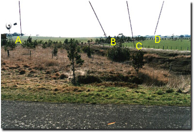
Notes from the Photo
A - Sedimentary hillsides with a reasonable level of tree cover. Less clearing has occurred here because the soil is not as productive and only suited to grazing and occasional cropping.
B - Tree planting has been very successful along the creek, adding a great deal of habitat value to the creek area.
C - Native grasses have been a major beneficiary of the fencing out, and they have flourished since.
D - The gently rounded volcanic hills have almost entirely been cleared because of their productive soils. Note the potato and winter crop paddocks that dot the area.
© State of Victoria (Agriculture Victoria) 1996 - .

This work, Victorian Resources Online, is licensed under a Creative Commons Attribution 4.0 licence. You are free to re-use the work under that licence, on the condition that you credit the State of Victoria (Agriculture Victoria) as author, indicate if changes were made and comply with the other licence terms.
The licence does not apply to ‘branding’ or some ‘images or photographs’ that may be owned by third parties. We ask you to seek prior approval to use images using the VRO feedback form. Access to higher quality images can also be provided on request.
This page was last updated on .