
Site 8: Concrete Weir, Blackbottom Road (issue: gully erosion)
Back to Bet Bet Creek Catchment Homepage
Landscape
As you drive away from Lexton along the road toward Brewster, you will come across a large concrete structure in the creek, 5.5 km from the Lexton township. It is not easily seen from the road so.
This structure was built in the early 1970’s and was put here for one purpose, to save the road from collapse. Look carefully at the concrete and the downstream banks, you should be able to detect a number of different projects completed over the years to protect this area.
Issues
1. Excessive runoff. The catchment area above is approximately 100 ha, but is steep and totally cleared, resulting in very high over-land flows, particularly during a thunderstorm.
2. Bank erosion. No vegetative protection on banks and stock encroachment. Force of water over banks and in the stream cuts into exposed banks.
3. Rabbits. Contribute to erosion by burrowing in the gully walls.
4. Loss of habitat. Salt kills off plants as does silt deposited from upstream.
Long Term Objectives
As you can see this structure was only a ‘band-aid solution’ to the real problem of excessive runoff. Constant work over the years to extend and shore up the structure demonstrates this. Behind the structure is an example of what needs to be done. Tree cover still exists on the most exposed hilltop areas. Pasture has been sown on the mid slopes which is utilising a high proportion of the rainfall.
Closer to the gully, diversion banks have been built and pipes used to divert runoff to the gully floor safely. Trees and grasses have been established to bind soil together and prevent further losses through erosion. Work has also been completed to remove rabbit burrows and to control rabbit harbour. Fencing is a priority for the site to protect it from stock, which also allows poisoning of rabbits to be undertaken on a regular basis. Additional work on the floor of the gully will utilise low weirs and plants like cumbungi and cane grass to trap silt and slowly raise the level of the stream bed.
The longer-term plan for this site is to extend the catchment works into the area upstream of the structure and to reduce runoff accordingly.
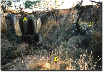
Notes from the Photo
A - A feat of engineering? Yes but it does not address the real issue of the excess runoff created by the change in land use above the road.
B - Vegetation provides the best, cheapest and most effective form of protection to areas that have the potential to erode. This is through both their root systems and their growth, which provides a protective cover to the soil.
C - A number of other attempts to control the erosion caused by water can be seen in the area You can judge for yourself their effectiveness.
© State of Victoria (Agriculture Victoria) 1996 - .

This work, Victorian Resources Online, is licensed under a Creative Commons Attribution 4.0 licence. You are free to re-use the work under that licence, on the condition that you credit the State of Victoria (Agriculture Victoria) as author, indicate if changes were made and comply with the other licence terms.
The licence does not apply to ‘branding’ or some ‘images or photographs’ that may be owned by third parties. We ask you to seek prior approval to use images using the VRO feedback form. Access to higher quality images can also be provided on request.
This page was last updated on .