
Site 7: Gullies, Forest Road (issue: gully erosion)
Back to Bet Bet Creek Catchment Homepage
Landscape
As you drive along the Forest Road from Lexton you will see a number of gullies emerge on either side of the road. On the left-hand side you will see a long gully which has been fenced out and planted to trees. First, look behind this and locate a small row of single trees that are fenced off, and run toward the main gully.
This was one of the first Lexton Landcare Group projects in 1985, when the entire gully was filled in and then replanted. This is a very successful form of rehabilitation, but very expensive to undertake, costing between $60 - $100 per metre of gully.
Now we are learning to live with the gullies, and rather than filling them in, we are stabilising and protecting them. We are still left with the unsightly cuts through the landscape, but we are able to halt soil loss and reclaim these areas effectively.
The gully on the left-hand side has had stabilising work completed on it.
Issues
1. Excessive runoff. Creates high levels of water flow over exposed areas.
2. Bank erosion. No vegetative protection on banks, stock climbing in area, water washes against exposed soil.
3. Rabbits. Continually exacerbate erosion by burrowing in the gully walls.
4. Loss of habitat. Salt kills off plants as does silt deposited from upstream.
The Restoration Process
Firstly, major volumes of water are channelled into pipes and other structures so they can get into the bottom of the gully safely, without causing further erosion. Next, the banks are dug out and smoothed into a gentle slope using an excavator. This smooths the area out and removes rabbit burrows which are a major threat to creek edges.
Finally, the area which has been fenced off and replanted to trees and grasses which use their roots to bind and protect the gully walls.
The longer-term plan for this site involves the continued stabilisation of banks until such work is complete. Following this work will begin in the stream-bed to stabilise it and to trap silt, slowly allowing for rebuilding of the gully to occur.
Repairing the landscape firstly requires the recognition of its different parts. Once this is achieved management for each part can be planned and carried out accordingly.
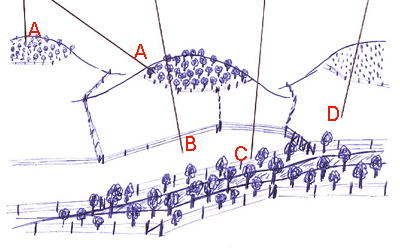
Notes from the Photo
A - Rocky exposed hilltops are major recharge sites, tree planting here is the only effective method of recharge control due to their deep root systems.
B - Flats are also fenced out as they produce differently in terms of pasture.
C - The creek area is protected from livestock by fencing to reduce erosion threats.
D - Gentle hillsides are planted to perennial grasses that provide both pasture for livestock and enhance water use to reduce recharge. Hillsides are further divided according to slope.
© State of Victoria (Agriculture Victoria) 1996 - .

This work, Victorian Resources Online, is licensed under a Creative Commons Attribution 4.0 licence. You are free to re-use the work under that licence, on the condition that you credit the State of Victoria (Agriculture Victoria) as author, indicate if changes were made and comply with the other licence terms.
The licence does not apply to ‘branding’ or some ‘images or photographs’ that may be owned by third parties. We ask you to seek prior approval to use images using the VRO feedback form. Access to higher quality images can also be provided on request.
This page was last updated on .