
Site 5: Yalong Road, Ben Moore Range (issue: discharge)
Back to Bet Bet Creek Catchment Homepage
Landscape
Drive along Yalong Road, continue past the two right angle bends till you reach a gate on the road. Proceed through here (please close the gate) and proceed slowly along the road, be careful the road is quite rough in places. The Range to your left is the Ben Moore Range, it is one of the most significant contributors to salt in the Bet Bet Creek, and Loddon River.
The Yalong Road area is estimated to contribute a significant portion of the 8 500 tonnes of salt which goes down the Bet Bet Creek annually. What you are seeing is salinity at it’s worst, the area has been cleared, the water cycle seriously altered, and very little ongoing management has been applied for controlling or alleviating salinity or its effects. To confirm this taste the water in the creeks which run across the road.
Issues
1. Recharge. The clearing of the hills above is the cause of what is seen around you.
2. Discharge. Most salt discharges directly into the streams. This destroys the clay’s ability to bind and makes the erosion worse. Salty water which comes to the surface evaporates, leaving salt behind, this continues, concentrating the salt and making the ground bare and hard like concrete. Where salt concentrations are less, grasses are replaced by tap rooted forbs that produce little growth.
3. Erosion. Higher runoff, salt and rabbits continue to make the gullies in this area worse.
Long Term Objectives
Some people may wish to totally forget about such an area, however, no one gains by that. The key is in stopping recharge on the hills behind us. This requires deep-rooted perennial vegetation like trees and pasture grasses.
In the gullies themselves, fencing will enable rabbits to be poisoned, stock to be away from poor water, and in the short term enable some grass growth to assist in binding the soil. In the longer-term, areas need to be battered and replanted where eroded. In very salty areas, special salt tolerant plants need to be established to help lower the water table.
The longer-term plan for this area is the establishment of new trees and pasture on the recharge areas, followed by fencing out discharge sites.
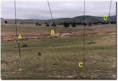
Notes from the Photo
A - Erosion is extremely obvious in this area. The combination of poorly structured soils, overgrazing, rabbit burrows and salt, all have played a part in this problem. Fixing it requires action on all the above - using a cause-based approach.
B - Saline discharge is very evident in this area. Because creeks are the lowest part of the landscape salt usually enters here. Salt destroys the clay’s ability to bind part of erosion, as well as killing life in the stream with high levels of salty water.
C - We talk a lot of perennial vegetation in salinity control, but what do we really mean? Depth of plant roots is the key component, the deeper the roots the more water they can access and utilise. Dig some plants up from around you and see how short their roots really are.
D - The high hills in the background are a major part of our salt problem. They are the major recharge areas due to poor vegetation and exposed rocky slopes. The return of perennial vegetation is a key priority.
© State of Victoria (Agriculture Victoria) 1996 - .

This work, Victorian Resources Online, is licensed under a Creative Commons Attribution 4.0 licence. You are free to re-use the work under that licence, on the condition that you credit the State of Victoria (Agriculture Victoria) as author, indicate if changes were made and comply with the other licence terms.
The licence does not apply to ‘branding’ or some ‘images or photographs’ that may be owned by third parties. We ask you to seek prior approval to use images using the VRO feedback form. Access to higher quality images can also be provided on request.
This page was last updated on .