
Site 4: Josephs Road, Ben Moore Range (issue: recharge)
Back to Bet Bet Creek Catchment Homepage
Landscape
You are now heading south on Josephs Road, having just turned off the Green Hill Creek Road (bitumen). Cross the creek and take the left fork in the road. Go through the gate (please close it behind you) and continue up the road. Take the right fork this time and follow the road to the next gate. Park in this vicinity and take a short walk down the road.
What you are looking at is the hillside, running from your right across the front of the road. Looking at the dead standing timber and regeneration further up you can picture how much tree cover was originally on these hills, and the size of the trees.
Look closely at the hillside and you should be able to see lines of rocky outcrops running directly up the hill. This is the position of the originally flat sedimentary layers of rock, which have now been turned vertical by earth movements during uplifting.
Issues
1. Recharge. Removing trees here has significantly altered the water balance across the entire range. On these shallow soils, trees are the only plants with roots deep enough to use the major portion of the areas rainfall. Furthermore the fractured rock, easily allows water to move through it and pick up salts deep below the surface.
Long Term Objectives
Re-establishing perennial vegetation is needed as a priority in this area. On areas of deeper and more gravelly soils, like the area where you are currently standing, perennial pastures (such as phalaris and cocksfoot) will effectively utilise rainfall.
On the steeper, more rocky and exposed slopes, tree planting is believed to be the only effective water utilisation strategy for the long term. The objectives then are to fence the areas and plant them accordingly. Tree establishment in this area will be a very expensive operation, but is a priority.
The longer-term plan for this site is to divide the steeper and gentler slopes and establish new perennial vegetation (such as trees and grasses) on them.
Notes from Photo
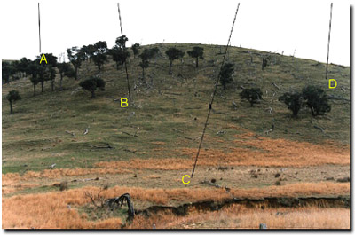
A - A quick glance around the area will show how much tree cover existed on the hills around us. In terms of biomass the original tree cover was a major element in water use and ecology on these hills.
B - The amount of rock visible on these hills provides an indication of how easily water can penetrate and recharge into areas out of reach of plant roots. Look for seams that indicate the vertical nature of the rock, and see how it is very broken and fragmented, allowing water easy access into it.
C - Have you seen a rabbit yet? These animals are very destructive. Seven rabbits eat as much as one sheep. The female breeds in six weekly cycles and can have at least four litters per season (i.e. approximately 20 new rabbits for each doe annually – equivalent to another 3 sheep in terms of grazing pressure).
D - Further to the issue of tree cover is one of possibly even more importance, that of re-generation of the vegetation. As you can see no regeneration is occurring in the grazed areas. This is a management issue to be addressed by landholders.
© State of Victoria (Agriculture Victoria) 1996 - .

This work, Victorian Resources Online, is licensed under a Creative Commons Attribution 4.0 licence. You are free to re-use the work under that licence, on the condition that you credit the State of Victoria (Agriculture Victoria) as author, indicate if changes were made and comply with the other licence terms.
The licence does not apply to ‘branding’ or some ‘images or photographs’ that may be owned by third parties. We ask you to seek prior approval to use images using the VRO feedback form. Access to higher quality images can also be provided on request.
This page was last updated on .