
Site 2: Doctors Creek Bridge, Talbot Road (issue: stream salinity)
Back to Bet Bet Creek Catchment Homepage
Landscape
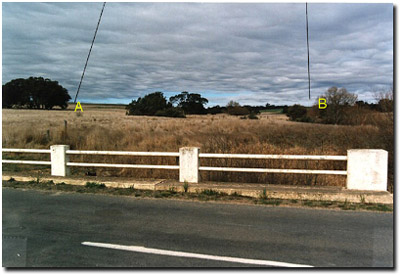
Park here and then walk up onto the bridge itself. Standing on the south side of the bridge look upstream, and you will see on your right an open woodland with trees scattered across the landscape and grass beneath. Looking to your left is an open grassland with very few trees. Doctors Creek marks the boundary between volcanic soils (left) and sedimentary soils (right).
The more fertile volcanic soils originally had a very sparse tree cover and have been almost entirely cleared for agriculture since settlement. Now turn around and look north. You see the sharp rocky bank on your right, this is the edge of the lava flow from Mount Mitchell, the large hill immediately to your right.
Cross the road and continue looking upstream, there is a wide range of different trees and shrubs along the creek. Try to identify the Leptospermum langigerum or woolly tea tree – the seed of which has been washed here from a patch of trees about 2.5 km upstream.
Now make your way down to the creek. Taste the water (don’t swallow – taste it and then spit it out). The water should not taste very salty (as compared to the water at Toll Bar Creek). Salt loads here vary from 400 EC in winter to about 2 500 EC in summer.
Salt loads are significantly lower here because volcanic soil occurs in the bulk of the catchment. This volcanic landscape has much less salt in it, and significant areas of the high salt sedimentary soils still have good tree cover, reducing recharge from them. Stream salinity and erosion are not major threats in this stream environment.
Issues
1. Stream revegetation. Because this area is in good condition we need to encourage landholders to protect it by fending, so the stream banks will only be grazed occasionally.
2. Seed collection. You may see a spiky plant north of the bridge. This is Bursaria spinosa or Sweet Bursaria - once common in the area this plant is now hard to find. Its seed will be collected for planting by the Landcare group.
Long Term Objectives
The longer-term plan for this site is to establish protective fencing - enabling bank and in-stream vegetation to regenerate.
Leptospermum lanigerum (Woolly Tea Tree) is one of the naturally occurring shrubs of the area. Favouring wet areas it grows in dense thickets along streamsides. It is an important part of the local ecosystem - providing excellent soil stabilisation as well as good food and shelter values for wildlife.
Notes from Photo
A - The volcanic plains are characterised by gentle slopes, thick grass and few trees. This was originally a plain dominated by perennial grasses such as Kangaroo Grass (Themeda triandra).
B - The sedimentary foothills, extending around Lexton, differ greatly from the volcanic areas. They have much more gravel and stone in the soil profile and were not cleared for cropping in the early years.
© State of Victoria (Agriculture Victoria) 1996 - .

This work, Victorian Resources Online, is licensed under a Creative Commons Attribution 4.0 licence. You are free to re-use the work under that licence, on the condition that you credit the State of Victoria (Agriculture Victoria) as author, indicate if changes were made and comply with the other licence terms.
The licence does not apply to ‘branding’ or some ‘images or photographs’ that may be owned by third parties. We ask you to seek prior approval to use images using the VRO feedback form. Access to higher quality images can also be provided on request.
This page was last updated on .