
Site 1: Toll Bar Park, Lexton
Back to Bet Bet Creek Catchment Homepage
Landscape
Cross the highway to the creek, standing on the south side of the bridge, looking upstream. You see the creek is a deeply cut channel and though the banks are stable, there is much loose material in the floor of the creek, a sign of erosion further upstream.
There is no shortage of vegetation, in particular the Eucalyptus camaldulensis or River Red Gum tree which lines the banks. These hardy trees have regenerated here themselves and are providing valuable shade, shelter and holding the banks together. You can see further regeneration as you look back between the highway and the creek.
Now venture down and taste the water in the creek (best to taste and then spit out). Can you taste the salt in the water? Depending on the time of year, salt here in the creek here varies from 2 000 EC in winter to about 10 000 – 15 000 EC in summer. The reason for this variation is the amount of water flowing – more water flowing in winter dilutes the salt loads. As a relative measure, sea water is over 50 000 EC, and the desirable limit for drinking water is around EC 800. Livestock can handle higher levels than humans. Most plants, however, find it difficult to survive in water that is consistently above 2 500 EC.
Issues
1. Erosion. Material here has obviously been washed down from further upstream. Erosion prevention methods are needed upstream.
2. Salinity. The creek is very salty as the water from an area of 2 400 hectares passes through here. Most salt is discharged into the beds of streams in the catchment.
Long Term Objectives
This area is in itself quite stable, the problems are coming down from upstream. Reduced runoff through better pastures on hills will reduce water flows (salt loads), as well as lessening one-off threats like floods following thunderstorms.
Salinity control works to utilise more water where it falls through pasture and trees will over time (say 5 – 10 years) lower saline discharge and salt loads in the stream.
The long-term plan for this site is the lowering of the stream EC below 2 500 for 8 months of the year.
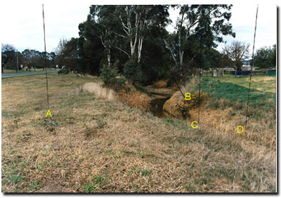
Notes from Photo
A - Natural regeneration of the dominant River Red Gum (Eucalyptus camaldulensis) is easily seen, the results of seed from the nearby trees, and reduced grass competition due to mowing.
B - Weeds are not pronounced in this area. However, gorse (or furze) hedge is evident – arising from seeds washed down stream. Catchment-based control is important to limit such seed spread.
C - Silt loads within the stream are very obvious - the result of erosion further upstream in the catchment. This deposition of silt has reduced the habitat value of the stream by filling in natural holes where fish and other organisms once lived.
D - Gentle sloping banks to the waters edge provides for good bank cover and contain potential erosion from this area.
© State of Victoria (Agriculture Victoria) 1996 - .

This work, Victorian Resources Online, is licensed under a Creative Commons Attribution 4.0 licence. You are free to re-use the work under that licence, on the condition that you credit the State of Victoria (Agriculture Victoria) as author, indicate if changes were made and comply with the other licence terms.
The licence does not apply to ‘branding’ or some ‘images or photographs’ that may be owned by third parties. We ask you to seek prior approval to use images using the VRO feedback form. Access to higher quality images can also be provided on request.
This page was last updated on .