
St Arnaud Mapsheet
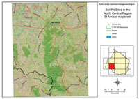 St Arnaud soil pit sites | These soil pits were described by Mark Imhof and John Martin (former DNRE) in 1996. Locations of many of these sites were determined from sites assessed by John Martin and Nabil Badawy (former Department of Agriculture) in 1977 as part of a reconnaissance survey of the St Arnaud area. The soil pits described here are examples of some of the major soil types in the St Arnaud area. There is, however, only limited information available on some soil types in the region and little mapping has taken place. therefore, the soil pits should be used as a guide only to some of the soils. It is not possible to give an estimate of how representative these sites are of major soil types in the area. |
We wish to thank Lindsay Ezard (former DNRE, St Arnaud) who was responsible for organising excavation of the soil pits. John Boadle also assisted. Julie Andrew (former DNRE, Stawell) assisted in locating and organising soil pits in the Navarre area. The support of Ken Stewart has also been much appreciated.
The involvement of all landholders who allowed access to their properties is very much appreciated. Support for this work was recieved from the former National Landcare Program.
© State of Victoria (Agriculture Victoria) 1996 - .

This work, Victorian Resources Online, is licensed under a Creative Commons Attribution 4.0 licence. You are free to re-use the work under that licence, on the condition that you credit the State of Victoria (Agriculture Victoria) as author, indicate if changes were made and comply with the other licence terms.
The licence does not apply to ‘branding’ or some ‘images or photographs’ that may be owned by third parties. We ask you to seek prior approval to use images using the VRO feedback form. Access to higher quality images can also be provided on request.
This page was last updated on .