
Soils and Land Capability of the Lexton Region
- Soils and Land Capability of the Lexton Region pdf report
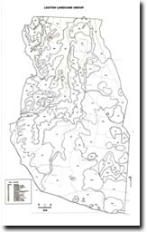
- Soils and Land Capability of the Lexton Region Map Units
- Soils and Land Capability of the Lexton Region Map
- Soils and Land Capability of the Lexton Region Appendices
To view the information PDF requires the use of a PDF reader. This can be installed for free from the Adobe website (external link).
This report on ' Soils and Land Capability of the Lexton Region' was prepared by L.A. Sullivan of Ballarat University in 1991. It was commissioned by the Lexton Landcare Group in order to provide information about the soils and land capability in the Landcare Group area at a scale suitable for interpretation at a regional level. The purpose of the inventory was to enable more effective planning of revegetation and soil improvement programmes as part of the Lexton Landcare Rehabilitation Strategy Project.
The work of Schoknecht (1988) was used as the major basis for this study. Additional work was undertaken to cover areas not surveyed as part of Schoknecht's report (approximately 50% of the study area); allow for readjustment of the boundaries of each map unit at the base map scale of 1:25 000; provide additional soil data for each map unit; and to modify some of Schoknecht's map units to provide greater precision.
 | Front Page & Table of Contents (PDF 335KB) | ||
| Introduction (PDF198KB) | |||
| Soils (PDF145KB) Classifcation of the Soil Description of the Major Soil Group | |||
| Land Degradation (PDF 80KB) | |||
| Forms of Degradation (PDF80KB) Salinity Sheet erosion Gully erosion Streambank erosion Wind erosion Soil compaction Slope failure Soil acidification | |||
| Land Capability Assessment (PDF134KB) | |||
| Map Units | |||
| Appendices (PDF 85KB) | |||
| Bibliography (PDF 80KB) |
© State of Victoria (Agriculture Victoria) 1996 - .

This work, Victorian Resources Online, is licensed under a Creative Commons Attribution 4.0 licence. You are free to re-use the work under that licence, on the condition that you credit the State of Victoria (Agriculture Victoria) as author, indicate if changes were made and comply with the other licence terms.
The licence does not apply to ‘branding’ or some ‘images or photographs’ that may be owned by third parties. We ask you to seek prior approval to use images using the VRO feedback form. Access to higher quality images can also be provided on request.
This page was last updated on .