
Geology
Back to Bet Bet Creek Catchment Homepage | Radiometrics
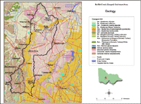 Bet Bet Geology | Geological mapping shown here comprises a combination of four 1:100 000 geological mapsheets, with various authors. It has been generalised and reproduced here from the Geological Survey of Victoria (GSV) geoscientific data set. Relevant references for the four studies (together with available links to information about them on DPIs website) are shown below: |
- Krokowski de Vickerod, J., Moore, D.H. and Cayley, R.A. 1997. St Arnaud 1:100 000 map area geological report. Geological Survey of Victoria 110.
- Cayley, R.A. and McDonald, P.A. 1995. Beaufort, 1:100 000 map area geological report. Geological Survey of Victoria, 104.
- Marlow, A.G. and Bushell, D. 1994. Dunolly, 1:100 000 map area geological report. Geological Survey of Victoria 105.
- Taylor, D.H., Wohlt, K.E., Simons, B.A., Maher, S., Morand, V.J. & Sapurmas, P., 2000. Creswick 1:100 000 map area geological report. Geological Survey of Victoria Report 117.
| The Bet Bet catchment is dominated by Cambrian-Ordovician deep marine metasediments that form the basement rock. These are marine sediments (including shales and sandstones) that were laid down in deep marine troughs and subsequently extensively folded, faulted and uplifted. In the Devonian period large masses (plutons) of granite and granodiorite were intruded through areas of the Ordovician sediments. Such plutons occur in the vicinity of Mt Hooghly, Dunluce, Ben More, Ben Major and Mt Beckworth. Contact metamorphism (caused by intense heat) occurred to some of the Ordovican rocks adjacent to the granite intrusions, resulting in the sedimentary rock becoming significantly altered and hardened (e.g. mudstones or shales can be altered into slates, schists or gneiss depending on the intensity of metamorphism). Subsequent erosion has left some of the more resistant metamorphic rock as raised ridges around some of the granite. In the Timor West area, for example, a metamorphic aureole of muscovite, schist, hornfels, slates and quartzites surrounds the granodiorite pluton (the 'Natte Yallock Pluton') - forming Mt Hooghly and the Black Ranges. These ridges rise sharply from the surrounding terrain with slopes exceeding 20%. Skirting these on all sides are colluvial aprons which grade gently (3-8 % slopes) to the alluvial plains (Day 1985). | 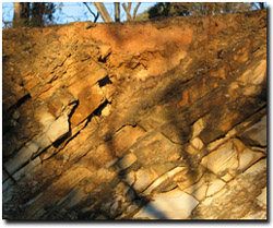 Ordovician rocks exposed in a road cutting near Bung Bong. |
 Exposed granodiorite on western slopes of Mt Hooghly | Between the late Devonian and Tertiary periods, extensive erosion occurred and thousands of metres of sediments were worn away and re-deposited. This would have exposed more of the granite plutons. In the Tertiary period, deep weathering of the older marine sediments and granites occurred. This resulted in lateritic soil profiles developing (although in this area somewhat poorly developed). These lateritic profiles have since been extensively eroded. From the late Tertiary to early Quaternary period, further uplift occurred in the highlands which initiated further significant erosion and the development of large fast flowing streams – originating in the highlands and flowed northwards. |
Deposition of pebbles, gravels and sands occurred in river valleys during the Tertiary period (approximately 3-7 million years ago), and the larger deposits are often referred to as 'deep leads'. The Avoca deep lead runs through both Natte Yallock and Timor West. These sediments covered the older marine sediments in some areas - and have since, in turn, become covered with more recent alluvial sediments in valley areas. These buried streams constitute a significant aquifer system throughout the northern slopes of the Western Uplands. The 'Avoca Deep Lead' in the Timor West area has a maximum depth of 70 metres at Wareek to less than 50 metres near Carmanuel Creek (Bet Bet Parish Geological map).
Former gravel beds of Tertiary rivers now also form the caps of some residual hills (e.g. three small locations in the Dunluce area). Remnants of a deeply weathered landscape persist in isolated locations on the upper slopes of the granite country (Day 1985). The present day uplands in the southern part of the region form the northern extension of the Pyrenees Ranges - a remnant of a former Tertiary peneplain.
| Extensive areas of basalt were extruded in the late Tertiary and early Quaternary periods. These are often referred to as the ‘Newer Volcanics’ on geology maps. These volcanic deposits covered large areas of ancestral stream-bed gravels as the lava flowed down former river valleys. Also, areas of older marine sediments and lower areas of granite outcrop were covered in some areas. The volcanic deposits are normally less than 60 metres deep (but can be up to 150 metres deep in some areas) and made up of a series of separate flows. Deposits can be quite extensive from south of Timor West through to Maryborough. |
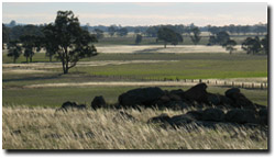
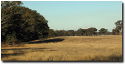 Lower terrace adjacent to present day Bet Bet Creek. | The most recent deposits have occurred in the late Tertiary to Quaternary period. These include more recent stream activity. Some of this activity was initiated as volcanic lava flows blocked existing streams. Extensive plains were traversed by leveed streams and the pattern of soil formation was controlled by climatic cycles. Commonly a lower terrace exists besides the present day floodplain and an older terrace occurs higher in the landscape. Different soils are present on the different terrace levels (reflecting age of development). Some areas have been covered by Quaternary deposits of both alluvial and windblown (aeolian) sediments (including calcareous clays). Soils can be quite variable in these areas. For example, the sandy clays developed on the alluvial plains adjacent to granitic country differ from the shrinking-swelling clays derived from basaltic sources (Day 1985). |
These areas are referred to as ‘Shepparton Formation’ on geology maps. Red calcareous Sodosols are common on the higher (or main) terrace. The most recent deposits have occurred within the last 10 000 or so years and are associated with present day streams and rivers. Soils developed on these areas consist of variable deposits of sand and clay with little soil profile development.
Related Links
The Creswick 1:100 000 Geological Report is available for download from the Minerals and Petroleum section of the DPI website. This report describes the geology, geophysics and mineral potential of the Creswick 1:100 000 mapsheet area (Mpa Sheet 7623) - with accompanying 1:50 000 geological and 1:100 000 geophysical maps. It provides a comprehensive account of the geological history, landscape evolution, rock units, geological structure, geophysical character and economic geology of the map area. The report also outlines the regional geological setting and provides a summary of previous geological work. Photographs, diagrams and tables complement the text and include compilation of radiometric ages and a summary of previous mineral exploration. There is a comprehensive reference list and a detailed excursion guide, designed to show the major geological features of the area.
The Geological Survey of Victoria has a wide range of geological information available on the DEDJT website - including: geophysical data, geological maps online, and exploration opportunities.
References
Cochrane, G.W., Quick, G.W., and Spencer-Jones, D. (eds) (1991). Introducing Victorian Geology. Geological Society of Australia (Victorian Division).
Day, C. (1985). A Study of the Geomorphic, Soil and Geohydrological Conditions of the Timor West/Black Ranges Areas. Department of Conservation. Forests and Lands
Land Conservation Council (1978). Report on the North central Study Area.
Ryan, S.P. (1993). The relative influence of regional and local groundwater processes on the development of secondary salinity in dryland areas of northern Victoria. Master of Science Thesis. Department of Geography and Environmental Science, Monash University.
Schoknecht, N.R. (1988). Land Inventory of the Loddon River catchment – a reconnaissance survey. Department of Conservation, Forests and Lands, Victoria.
© State of Victoria (Agriculture Victoria) 1996 - .

This work, Victorian Resources Online, is licensed under a Creative Commons Attribution 4.0 licence. You are free to re-use the work under that licence, on the condition that you credit the State of Victoria (Agriculture Victoria) as author, indicate if changes were made and comply with the other licence terms.
The licence does not apply to ‘branding’ or some ‘images or photographs’ that may be owned by third parties. We ask you to seek prior approval to use images using the VRO feedback form. Access to higher quality images can also be provided on request.
This page was last updated on .