
Mount Greenock
|
This information has been obtained from the report: Eruption Points of the Newer Volcanic Province of Victoria by Neville Rosengren. This report was published in 1994 and was prepared for the National Trust of Australia (Victoria) and the Geological Society of Australia (Victorian Division). The review of eruption points was based on an earlier unpublished manuscript Catalogue of the post-Miocene volcanoes of Victoria compiled by O P Singleton and E B Joyce (Geology Department, University of Melbourne 1970). |
| 37 12 04S 143 43 42E (external link); 7623-4-2 (Talbot) 419791. 3 km SE of Talbot. Mount Greenock Road. | 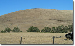 Mt Greenoch (January 2004) Photo: A Fadersen | |
Talbot and Clunes. | ||
Much of the area is public land in grazing lease. Private land at base, outcrop of lava and scoria. | ||
Type 9: | Composite cone of scoria overlying lava flows. | |
This is a tall scoria cone with a broad shallow crater open to the northwest. In the crater are blocks and bombs of scoriaceous basalt. Long lava flows extend both north and south from the cone. The flow to the north has been eroded by McCallum Creek which is a lateral stream. On the eastern base of the cone, the stream valley exposes a lava flow and underlying sedimentary rocks. The lava flow and the scoria cone overlie the Greenock lead (a buried valley with auriferous gravels). A line of mine tailing and abandoned mining relics occur on the margins of the lava flow. | ||
390+ m; 105 m. | ||
State: | This is an outstanding example of a volcano and lava flow associated with a deep lead. It is one of the few large scoria cones on public land and contains abundant outcrop and morphological evidence of its volcanic origin. It has the potential for extensive educational use in earth and social science study. | |
Mt Greenock
© State of Victoria (Agriculture Victoria) 1996 - .

This work, Victorian Resources Online, is licensed under a Creative Commons Attribution 4.0 licence. You are free to re-use the work under that licence, on the condition that you credit the State of Victoria (Agriculture Victoria) as author, indicate if changes were made and comply with the other licence terms.
The licence does not apply to ‘branding’ or some ‘images or photographs’ that may be owned by third parties. We ask you to seek prior approval to use images using the VRO feedback form. Access to higher quality images can also be provided on request.
This page was last updated on .