
Lake Burrumbeet (Callender Bay)
|
This information has been obtained from the report: Eruption Points of the Newer Volcanic Province of Victoria by Neville Rosengren. This report was published in 1994 and was prepared for the National Trust of Australia (Victoria) and the Geological Society of Australia (Victorian Division). The review of eruption points was based on an earlier unpublished manuscript Catalogue of the post-Miocene volcanoes of Victoria compiled by O P Singleton and E B Joyce (Geology Department, University of Melbourne 1970). |
| 37 29 00S 143 37 30E (external link); 7623-3-2 (Windermere) 322488. 3 km W of Burrumbeet. Western Highway. | 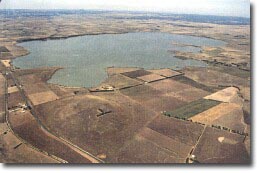 Lake Burrumbeet (Callender Bay & Mount Callender in foreground) | |
Ripon. | ||
Public land. Lake Burrumbeet. Excellent exposures in Lake Burrumbeet shore cliffs. | ||
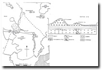
Type 7: | Tuff ring and maar crater. | |
| Callender Bay is a small semi-circular bay forming the northwestern edge of Lake Burrumbeet. The bay opens to the southeast into the lake and occupies the site of one of several explosive eruption points which produced tuff and basaltic agglomerate. Tuff forms Mount Callender to the west and Stewarts Hill on the northeastern side of Callender Bay and these may also be eruption points. The tuff outcrops as shoreline cliffs around Callender Bay and Stewarts Point. Material weathered from the tuff forms gravels along the beaches here. There are excellent exposures of tuff beds showing crossbedding and bomb sag. Weathered basalt blocks and lumps of granite occur in the beach gravels - the granite apparently being brought to the surface as bombs during volcanic eruption. Overlying the pyroclastic rocks is a lava flow and basalt cliffs are exposed around Callender Bay. | ||
400+ m ; 15 m. | ||
National: | An outstanding example of pyroclastic bedding. Good example of country rock carried to the surface by volcanic eruption. | |
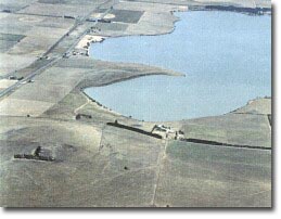 Callender Bay (Lake Burrumbeet) |
© State of Victoria (Agriculture Victoria) 1996 - .

This work, Victorian Resources Online, is licensed under a Creative Commons Attribution 4.0 licence. You are free to re-use the work under that licence, on the condition that you credit the State of Victoria (Agriculture Victoria) as author, indicate if changes were made and comply with the other licence terms.
The licence does not apply to ‘branding’ or some ‘images or photographs’ that may be owned by third parties. We ask you to seek prior approval to use images using the VRO feedback form. Access to higher quality images can also be provided on request.
This page was last updated on .