
Site 12 Merin Merin Swamp - needs updating 13_3_20
The site appears to be in a stable environmental condition
Description
Merin Merin Swamp at an elevation of 300 metres, together with Middle Swamp nearby form the southern end of a wetlands complex that extends north onto the Northern Riverine Plain. The swamps receive water via localised runoff from surrounding volcanic cones that have been mapped as high recharge (Mt Glasgow, Mt Cameron and Merin Hill). Both swamps are locally important due to their high wildlife value and connection with Clunes State Forest. Previous land use had been timber harvesting during the Gold rush era and beyond and grazing (grazing licence was removed in the early 1990s). The area is now a State Game Reserve managed by Parks Victoria.
| Vegetation Description and Composition Note: there are three vegetation quadrats surveyed at both wetlands monitored in the Loddon catchment. Parks Victoria assists with funding the additional vegetation surveys. This shallow freshwater marsh represents Red Gum Wetland EVC and contains a combination of Woodland dominated by Eucalyptus camaldulensis (Red Gum) and Open-Sedgeland dominated by Juncus spp. (rushes) Carex spp. (sedges), and Eleocharis spp. (spike rushes). The swamp contains high habitat values due to the mixed age classes of Red Gums present and connection to the west with State forest. There is a very high proportion of introduced species in the herbaceous layer, particularly Phalaris (Canary Grass) and members from the Asteraceae family. This is due to the long grazing history that the swamp once had. Dry seasonal conditions have temporarily reduced the cover abundance of some of these species. | 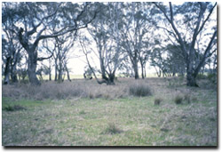 Merin Merin Swamp in spring 2002 |
Two salt indicator species were present being Critesion marinum (Sea Barley Grass) and Lolium rigidum (Wimmera Rye Grass). Although these are common agricultural weeds, their appearance and any spread should be closely monitored because the northern end of the swamp and the drainage line running to the swamp from the north western corner have been mapped as potentially at high risk from dryland salinity.
Merin Merin Swamp has remained dry since January 2001. Some aquatic species, Marsilea spp. (Nardoo) and Glyceria australis (Australian Sweet-grass) were still present in spring 2002 but their level of abundance has been greatly reduced by dry seasonal conditions.
Tree Health
Twelve trees are monitored for tree canopy health using a 20-point system assessing canopy size and density, number of dead branches and extent of epicormic growth. Leaf damage by insects is also assessed. Most trees are healthy and their scores have not altered very much since monitoring commenced in 1997. Some have experienced decline whereas three trees have recorded a large improvement in health. Four trees on the eastern side of the swamp were experiencing large amounts of insect attack and displaying epicormic growth in 2002. These are indications that the trees are experiencing drought stress.
Water quality
Merin Merin Swamp has been inundated and sampled four times since 1997 but has remained dry since January 2001. Some general observations recorded so far were the water quality was generally very good in relation to dissolved oxygen, pH and conductivity levels, but nutrient concentrations often exceeded maximum limits for the prevention of eutrophication (nutrient enrichment). The swamp often contains only a few centimetres of water and this would be an important factor in high nutrient and turbidity readings. Merin Merin swamp receives localised runoff therefore high phosphorus and nitrogen readings are a reflection of the effects of surrounding landuse from fertilisers, plant/animal runoff and nitrogen fixing pastures (clover and lucerne).
Macroinvertebrate surveys are not conducted at this site as it rarely contains enough water (>30 cm in late spring) for regular surveys to occur.
Groundwater and Salinity
Two bores are monitored at this site, one is shallow and located on the eastern side in the new volcanic land system, the other drilled into a deeper aquifer layer and is located on the sedimentary hills land system. The shallower bore is very responsive to seasonal weather variation and has fluctuated from 1.5-4.0 metres since 1997. The other bore has remained at around 15 metres below natural surface and has shown a slight downward trend in response to dry seasonal conditions. Both recorded >11000 EC in 2002 (i.e. highly saline groundwater).
Birds
Bird species seen at the time of vegetation and tree health surveys include:-
Black Faced Cuckoo Shrike, Corella, Galah, Kookaburra, Magpie, Musk Lorikeet, Noisy Miner, Red-rumped Parrot, Red Wattlebird, Richardson’s Pipit, Starling, Striated Pardalote, Sulphur-crested Cockatoo, Welcome Swallow, White-browed Woodswallow and Willie Wagtail.
Site Threats
- Possible stock grazing
- grazing by rabbits and hares
- possible incorrect water regime
- continued weed invasion in particular Phalaris spp. (now present in Quadrat B and C.)
© State of Victoria (Agriculture Victoria) 1996 - .

This work, Victorian Resources Online, is licensed under a Creative Commons Attribution 4.0 licence. You are free to re-use the work under that licence, on the condition that you credit the State of Victoria (Agriculture Victoria) as author, indicate if changes were made and comply with the other licence terms.
The licence does not apply to ‘branding’ or some ‘images or photographs’ that may be owned by third parties. We ask you to seek prior approval to use images using the VRO feedback form. Access to higher quality images can also be provided on request.
This page was last updated on .