
Site LP111
Back to Bet Bet Creek Catchment Homepage
Groups: Timor West Landcare Group
Aust. Soil Class.: Eutrophic, Mottled-, Subnatric, Red SODOSOL
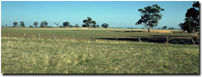
General Site Description: Alluvial plain about 10 km from Avoca River.
Geology: Devonian granite and Quaternary colluvium.
 Site LP111 Soil Landscape |
Soil Profile Morphology:
| Surface Soil | 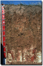 Site LP111 Soil Profile | ||
| A1 | 0-5 cm | Dark brown (10YR3/3); coarse sandy clay loam; weak coarse blocky structure; firm consistence (dry); contains a common (15%) amount of quartz gravel (5 mm average size); pH 6.2; abrupt change to: | |
| A2 | 5-15 cm | Brown (10YR4/3) with reddish brown (5YR4/4) mottles; coarse sandy clay loam; weak coarse blocky structure; very firm consistence (moderately moist); contains few (10%) quartz gravels (5 mm average diameter); pH 6.1; sharp change to: | |
| Subsoil | |||
| B1 | 15-35 cm | Red (2.5YR4/8) with yellowish brown (10YR5/4) mottles; light medium clay (coarse sand); very firm consistence (moderately moist); contains a few (5%) quartz gravels (4 mm average diameter); pH 6.1; gradual change to: | |
| B21 | 35-60 cm | Yellowish red (5YR5/6) with yellowish brown (10YR5/4) mottles; light clay (coarse sand); strong consistence (moderately moist); contains a few (5%) quartz gravels (4 mm average diameter); pH 5.8; gradual and wavy change to: | |
| B22 | 60-80 cm | Yellowish red (5YR4/6) with yellowish brown (10YR5/8) patches; light clay; moderate fine prismatic structure, parting to moderate medium blocky structure; strong consistence (moderately moist); pH 5.3; clear wavy change to: | |
| B/C | 80-110 cm | Weathered Granite with columns of yellowish red (5YR4/6) clay from overlying horizon. | |
Key Profile Features:
- Strong texture contrast between surface (A) horizons and upper subsoil (B21) horizon.
- Contains quartz gravels throughout the profile.
- Weathered granite at 80 cm.
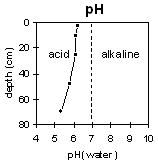
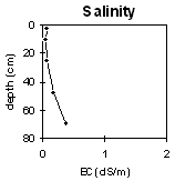
pH | Salinity Rating | |||
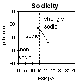
Surface (A1 horizon) | Slightly acid | Very low | Marginally Sodic | None 1 |
Subsoil (B21 horizon) | Slightly acid | Very low | Sodic | Strong 2 |
Deeper subsoil (at 60-80 cm) | Strongly acid | Low | Strongly Sodic (at 35-60 cm) | Strong |
 |  |  |  |
Horizon | Horizon Depth | pH (water) | pH CaCl2 | EC dS/m | NaCl % | Exchangeable Cations | Ex Al mg/kg | Ex Ac meq/100g | Field pF2.5 | Wilting Point pF4.2 | Coarse Sand (0.2-2.0mm) | Fine Sand (0.02-0.2mm) | Silt (0.002-0.02mm) | Clay (<0.002mm) | |||
Ca | Mg | K | Na | ||||||||||||||
meq/100g | |||||||||||||||||
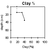
A1 | 0-5 | 6.2 | 5.1 | 0.07 | 2.4 | 2.6 | 0.33 | 0.51 | 18.7 | 6.9 | 33 | 36 | 9 | 18 | |||
A2 | 5-15 | 6.1 | 4.6 | 0.05 | 1.5 | 2.3 | 0.17 | 0.49 | 16.4 | 6.2 | |||||||
B1 | 15-35 | 6.1 | 4.5 | 0.06 | 0.99 | 4.7 | 0.23 | 0.94 | 20.5 | 10.4 | 30 | 29 | 9 | 33 | |||
B21 | 35-60 | 5.8 | 4.5 | 0.17 | 0.31 | 6.5 | 0.27 | 1.8 | 23 | 25.5 | 13.5 | 22 | 29 | 8 | 41 | ||
B22 | 60-80 | 5.3 | 4.3 | 0.37 | 21 | ||||||||||||
Management Considerations:
Whole Profile
- Management strategies for all soils should aim to increase organic matter levels in the surface soil; minimise the degradation of soil aggregates and porosity; promote the development of stable biopores; improve the calcium status of the cation complex (when sodium is a significant part – i.e. sodic) and break up any hardpans. Less frequent tillage, using less aggressive implements, and working the soil at optimum moisture contents can all assist in maintaining soil aggregation and porosity as well as reducing the breakdown of organic matter.
- Plant available water capacity (PAWC) is estimated to very low-low – i.e. 50 mm. This is based on the available laboratory data and assuming an effective rooting depth of 35 cm. Effective rooting depth will be restricted by the strongly sodic deeper subsoil.
- Values of exchangeable magnesium are higher than 40% throughout the soil profile (up to 73% with depth). Such levels in some soils may induce potassium deficiency (Baker and Eldershaw, 1993).
- The level of the organic carbon indicates that the organic matter of the shallow surface soil is low. Organic matter is important for reducing slaking and enhancing soil aggregation, fertility and water holding capacity, as well as holding together this highly sandy (69%) soil. Organic matter levels will build up under pasture but will decline if cultivation takes place. Practices such as residue retention, minimum tillage and including pasture rotations should be utilised if cropping occurs.
- The surface horizons have a low inherent fertility (based on the sum of the basic exchangeable cations). Organic matter will be important for enhancing fertility
- The surface horizons are sodic and moderately dispersive after remoulding. This indicates that the surface soil may disperse when worked in a moist condition even though it may not disperse in its natural state. The action of rain impact on the soil surface may also cause dispersion. By maintaining some pasture or stubble cover this may be prevented. Cultivation or over-stocking should be avoided if the soil is in a moist to wet condition.
- The bleached subsurface (A2) horizon indicates that periodic waterlogging occurs on top of the more slowly permeable subsoil. This horizon is likely to become 'spewy' as a result.
- The dense and coarsely structured subsoil is sodic (becoming strongly sodic at 30 cm depth) and strongly dispersive with a low calcium to magnesium ratio (<1). This will result in restricted root and water movement in the subsoil. Water is likely to build up on the top of the subsoil after heavy rains causing waterlogging of the more porous surface horizons.
- The subsoil becomes strongly acid at about 60 cm depth with moderate exchangeable aluminium levels. This could affect some deeper rooted plant species that are aluminium sensitive (e.g. lucerne).
© State of Victoria (Agriculture Victoria) 1996 - .

This work, Victorian Resources Online, is licensed under a Creative Commons Attribution 4.0 licence. You are free to re-use the work under that licence, on the condition that you credit the State of Victoria (Agriculture Victoria) as author, indicate if changes were made and comply with the other licence terms.
The licence does not apply to ‘branding’ or some ‘images or photographs’ that may be owned by third parties. We ask you to seek prior approval to use images using the VRO feedback form. Access to higher quality images can also be provided on request.
This page was last updated on .