
Site LP108
Back to Bet Bet Creek Catchment Homepage
Groups: Timor West Landcare Group
Aust. Soil Class.: Eutrophic, Mesonatric, Red SODOSOL
Great Soil Group: solodic
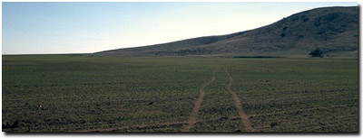
General Site Description: Footslope of Mount Hooghly.
Geology: Colluvial deposits from Mt Hooghly (metamorphic aureole of schist and phyllite).
 Site LP108 Soil Landscape |
Soil Profile Morphology:
| Surface Soil | 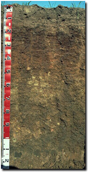 Site LP108 Soil Profile | ||
| A1 | 0-5 cm | Dark brown (7.5YR3/4); sandy clay loam (light); weak blocky structure; weak consistence (moderately moist); few (10%) colluvial gravels (av. 8 mm diameter - quartz and schist); pH 5.5; abrupt change to: | |
| A2 | 5-12 cm | Strong brown (7.5YR4/6) conspicuously bleached (7.5YR7/4d); sandy clay loam; weak consistence (moderately moist); few (10%) colluvial gravels (av. 6 mm diameter - quartz and ferruginised schist); pH 6.1; sharp change to: | |
| Subsoil | |||
| B1 | 12-25 cm | Yellowish red (5YR4/6) with dark brown (7.5YR4/4) mottles; sandy clay (coarse); weak coarse blocky structure; strong consistence (moderately moist); few (5%) gravels (av. 5 mm diameter - ferruginous & quartz); pH 7.1; wavy and clear change to: | |
| B21 | 25-50 cm | Yellowish red (5YR4/6) with dark brown (7.5YR4/4) & strong brown (7.5YR5/6) mottles; medium clay; moderate medium sized blocky structure, parting to strong fine blocky structure; strong consistence (moderately moist); few (5%) gravels (av. 5 mm diameter - ferruginous & quartz); most roots stop at 50 cm; pH 8.3; wavy and clear change to: | |
| B22 | 50-70 cm | Dark yellowish brown (10YR4/4) and reddish brown (5YR4/4); light medium clay; moderate medium sized blocky structure; very firm consistence (moderately moist); few (5%) gravels (av. 7 mm diameter); pH 8.8; wavy and gradual change to: | |
| B23 | 70-90 cm | Dark brown (7.5YR3/4); light medium clay; strong medium sized blocky structure, parting to moderate very fine blocky structure; very firm consistence (moderately moist); few (10%) colluvial gravels (av. 8 mm diameter - quartz and phyllite); few roots stop at 90 cm; pH 9.0; gradual and wavy change to: | |
| B24 | 90-120 cm | Yellowish red (5YR4/6); medium clay; moderate medium sized blocky structure, parting to strong fine polyhedral structure (with clay tubules); few (5%) gravels (av. 8 mm diameter - phyllite & quartz); pH 9.0: | |
| D | 120+ cm | Dark yellowish brown (10YR3/4) with patches of dark red (2.5YR3/6) and yellowish brown (10YR5/8); sandy loam; many (40%) quartzite gravels (av. diameter 7 mm). | |
Key Profile Features:
- Strong texture contrast between surface (A) horizons and upper subsoil (B21) horizon.
- Conspicuously bleached subsurface (A2) horizon.
- Contains quartz and ferruginous gravels throughout profile
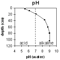
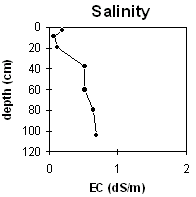
pH | Salinity Rating | |||
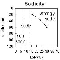
Surface (A1 horizon) | Strongly acid | Very Low | Marginally Sodic | None |
Subsoil (B1 horizon) | Slightly alkaline | Medium (at 25 cm) | Strongly Sodic | Complete |
Deeper subsoil (at 90+ cm) | Strongly alkaline | Medium | Strongly Sodic | Strong (at 50-70 cm) |
 |  |  |
Horizon | Horizon Depth | pH (water) | pH CaCl2 | EC dS/m | NaCl % | Exchangeable Cations | Ex Al mg/kg | Ex Ac meq/100g | Field pF2.5 | Wilting Point pF4.2 | Coarse Sand (0.2-2.0mm) | Fine Sand (0.02-0.2mm) | Silt (0.002-0.02mm) | Clay (<0.002mm) | |||
Ca | Mg | K | Na | ||||||||||||||
meq/100g | |||||||||||||||||
A1 | 0-5 | 5.5 | 4.8 | 0.19 | 2.2 | 1.7 | 0.5 | 0.51 | 10 | 5.8 | 18.2 | 12 | 60 | 15 | 12 | ||
A2 | 5-12 | 6.1 | 4.9 | 0.07 | 1.8 | 1.6 | 0.32 | 0.36 | 4.2 | 14.1 | |||||||
B1 | 12-25 | 7.1 | 5.7 | 0.11 | 1.5 | 4.5 | 0.52 | 1.2 | 9.1 | 19.7 | 14 | 50 | 14 | 23 | |||
B21 | 25-50 | 8.3 | 7.2 | 0.51 | 0.09 | 1.8 | 9.4 | 1.2 | 3.9 | ||||||||
B22 | 50-70 | 8.8 | 7.7 | 0.51 | 0.09 | 1.4 | 8.8 | 1 | 8.8 | ||||||||
B23 | 70-90 | 9 | 8.1 | 0.64 | 0.09 | ||||||||||||
B24 | 90-120 | 9 | 8.1 | 0.68 | 0.1 | ||||||||||||
Whole Profile
- Management strategies for all soils should aim to increase organic matter levels in the surface soil; minimise the degradation of soil aggregates and porosity; promote the development of stable biopores; improve the calcium status of the cation complex (when sodium is a significant part – i.e. sodic) and break up any hardpans. Less frequent tillage, using less aggressive implements, and working the soil at optimum moisture contents can all assist in maintaining soil aggregation and porosity as well as reducing the breakdown of organic matter.
- Plant available water capacity (PAWC) is estimated to be very low (estimated at approximately 40 mm) for this soil profile. This is based on the available laboratory data (to an estimated rooting depth of 25 cm). Effective rooting depth will be restricted by the strongly sodic subsoil and medium salinity rating at 25 cm depth.
- Values of exchangeable magnesium are greater than 35% throughout the soil profile (up to 57% with depth). Such levels in some soils may cause cation imbalances - which has shown to induce potassium deficiency (Baker and Eldershaw, 1993).
- Maintaining surface cover is important on both light textured sloping land and shallow surface soils, in order to restrict loss of surface soil by sheet erosion. It is also important to build up organic matter levels in the surface soil so as to improve soil fertility, aggregate stability and water holding capacity.
- The surface horizons have a low inherent fertility (based on the sum of the basic exchangeable cations) - legumes would assist in building up soil fertility.
- The organic carbon value indicates that the organic matter in the surface horizon is low. Organic matter is important for reducing slaking and enhancing soil aggregation, fertility and water holding capacity in soils with a high sand (72%) and silt content. Organic matter levels will build up under pasture but will decline if cultivation takes place. Practices such as residue retention, minimum tillage and including pasture rotations should be utilised if cropping occurs.
- The surface horizon has a moderately low pH. This can lead to toxic levels of exchangeable aluminium being available to the plants. In this case the exchangeable aluminium level is quite low and only some of the most highly sensitive species may be affected. Lime can be used to increase soil pH but it should be noted that a pH/aluminium test is best performed from samples taken across the paddock and bulked together. Other factors also need to be considered before lime is recommended (e.g. pasture species grown, method of application, local trial responses, soil surface structure and likely cost/benefit).
- The bleached subsurface (A2) horizon indicates that periodic waterlogging occurs on top of the more slowly permeable subsoil. This horizon is likely to become 'spewy' as a result.
- The dense and coarsely structured subsoil (B21) is strongly sodic and strongly dispersive (with a low calcium to magnesium ratio (<1)) from 20 cm. This will result in restricted root and water movement in the subsoil. Water is likely to build up on the top of this zone after heavy rains causing waterlogging of the more porous surface horizons.
- The soil below 25 cm has a medium salinity rating. This may affect a few of the more salt sensitive plant species (e.g. faba beans, linseed and some clovers).
- The subsoil becomes strongly alkaline at about 50 cm, which indicates that some nutrients (e.g. copper, iron, manganese and zinc) may be poorly available to deeper rooted species.
References:
Baker, D.E. and Eldershaw, V.J. (1993). Interpreting Soil Analysis for Agricultural Land Use in Queensland. Project Report Series. Queensland, Department of Primary Industries.
© State of Victoria (Agriculture Victoria) 1996 - .

This work, Victorian Resources Online, is licensed under a Creative Commons Attribution 4.0 licence. You are free to re-use the work under that licence, on the condition that you credit the State of Victoria (Agriculture Victoria) as author, indicate if changes were made and comply with the other licence terms.
The licence does not apply to ‘branding’ or some ‘images or photographs’ that may be owned by third parties. We ask you to seek prior approval to use images using the VRO feedback form. Access to higher quality images can also be provided on request.
This page was last updated on .