
Marong map unit Qbg
Back to: A Land Capability Study of the Rural City of Marong
| Map Unit: | Quaternary basalt, drainage depression | Map Unit Symbol: | Qbg |
| % of Study Area: | 0.2 |
General Description:
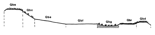
The wetter areas of the basalt plain form swampy depressions. As with all drainage units, the associated soils are variable. They are typically yellow duplex with silty loam top soils, bleached A2 horizons and heavy, mottled clay subsoils. Minor soil variations include absent A2 horizons and whole-coloured subsoils on the edge of depressions where drainage is slightly better, and self-mulching grey uniform clays In shallower depressions. In very slight-depressions, between rock outcrops, the soils are similar to those on the very gentle slopes.
Site characteristics:
| Parent material age: | Quaternary | Depth seasonal watertable: | 0 m |
| Lithology: | Basalt | Potential recharge to groundwater: | Low |
| Landform Pattern: | Lava plain | Flooding risk: | High |
| Element: | Swamp | Drainage: | Very poorly drained |
| Slope common: | 1 % | Depth to hardrock: | 1.1 m |
| Slope range: | 0 - 3 % | ||
| Rock outcrop: | 2 - 10 % |
Major vegetation: Red Gum, Yellow Box, Grey Box, Buloke, Sea Barley Grass, Spiny Rush, Wallaby Grass
Present land use: Native forest (partially cleared), grazing and native pasture
| Land degradation: | Water erosion | Wind erosion | Salting | Acidification | |
Sheet/rill | Gully | ||||
| Susceptibility | Low | Moderate | Very Low | High | Moderate |
| Incidence | Low | Low | Very Low | Moderate | Low |
Soil profile characteristics:
| Permeability (measured - average, range): | N.A. |
| Permeability (estimated): | Very slow |
| Available water capacity: | 151 mm H2O |
| Linear shrinkage (B horizon): | 14 % |
Soil profile description:
| A1 | 0-12 cm | Brownish grey (10YR5/1) silty loam, moderate structure, angular blocky pads 10-20 mm, smooth fabric, moderately weak consistence, pH 6.9. Clear transition to |
| A2 | 12-27 cm | Greyish yellow brown (10YR6/2) fine sandy loam, bleached (10YR8/2) when dry, weak structure, subangular blocky peds 10-20 mm, rough fabric, moderately firm consistence, pH 6.1. Abrupt transition to |
| B21 | 27-52 cm | Greyish yellow brown (10YR5/2) heavy clay, many distinct orange mottles, moderate structure, subangular blocky pads 10-20 mm, smooth fabric, moderately firm consistence, pH 5.4. Clear transition to |
| B22 | 52-73 cm | Dull yellowish brown (10YR5/4) heavy clay containing wind blown quartz particles, many distinct dark brown mottles, weak structure, subangular blocky peds 10-20 mm, smooth fabric, moderately firm consistence, pH 5.7. Clear transition to |
| B23 | 73-90 cm | Dull yellowish brown (10YR5/4) medium heavy clay, many distinct pale brown mottles, moderate structure, angular blocky pads 10-20 mm, smooth fabric, moderately weak consistence, less than 2% basalt fragments and carbonate nodules, pH 6.9. Clear transition to |
| B24 | 90-107 cm | Pale grey/brown (2.5YR6/2) medium heavy clay, common distinct yellow mottles, strong structure, subangular blocky peds less than 2 mm, smooth fabric, moderately weak consistence, abundant basalt fragments and carbonate nodules, pH 7.4 |
| C | 107 cm | Rock |
Soil classification:
| Factual Key (Northcote): | Dy 3.42 (major) Dy 3.14, Uf 6.31/3 (minor) |
| Australian Soil Classification: | Bleached, Kurosolic, Redoxic, Hydrosol; deep, medium, silty, non-gravelly |
| Unified Soil Group: | CH |
Interpretation of soil analyses*
Horizon | pH | Gravel % | E.C. (salts) | Nutrient Status | P | K | Al | Organic Matter | Dispersibility |
| A1 | 6.9 | 0.7 | VL | M | S | S | S | H | L |
| A2 | 6.1 | 5.8 | VL | VL | D | S | S | L | H |
| B21 | 5.4** | 0.9 | VL | M | D | S | T | L | H |
| B22 | 5.7 | 0.4 | VL | M | D | S | S | L | H |
| B23 | 6.9 | 2.4 | VL | H | D | S | S | L | H |
| B24 | 7.4 | 43.0 | L | VH | D | S | S | L | H |
Land capability assessment
Land Use | Class | Major limiting feature(s)/ landuse |
| Agriculture (CTS values) | C3T2S5 | High seasonal watertable |
| Effluent disposal (septic tanks) | 5 | High seasonal watertable, very poor drainage, high risk of flooding, very slow permeability |
| Farm dams (earthen) | 5 | High seasonal watertable |
| Building foundations - slab | 5 | Very poor drainage, high seasonal watertable, high risk of flooding |
| Building foundations - stumps/footings | 5 | Very poor drainage, high seasonal watertable, high risk of flooding |
| Secondary roads | 5 | High risk of flooding, high seasonal watertable, very poor drainage |
| Urban residential | 5 | Secondary roads, building foundations |
| Rural residential | 5 | Farm dams, effluent disposal, secondary roads, building foundations |
The high resolution PDF file provided on this page can be viewed using the free Adobe PDF reader, this software can be installed for free from the Adobe website (external link).
A Land Capability Study of the Rural City of Marong - map unit Qbg - (PDF - 40 KB)
© State of Victoria (Agriculture Victoria) 1996 - .

This work, Victorian Resources Online, is licensed under a Creative Commons Attribution 4.0 licence. You are free to re-use the work under that licence, on the condition that you credit the State of Victoria (Agriculture Victoria) as author, indicate if changes were made and comply with the other licence terms.
The licence does not apply to ‘branding’ or some ‘images or photographs’ that may be owned by third parties. We ask you to seek prior approval to use images using the VRO feedback form. Access to higher quality images can also be provided on request.
This page was last updated on .