
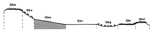
Marong map unit Qbe
Back to: A Land Capability Study of the Rural City of Marong
| Map Unit: | Quaternary basalt, gentle slope | Map Unit Symbol: | Qbe |
| % of Study Area: | 0.2 |
General Description:
The gentle outwash slopes of the basalt cone. The soils are shallow red duplex with dark reddish brown clay loam top soils and brownish red, light medium clay subsoils. Detailed site information was not collected because the unit is small and the soil profile is similar to that on the very gentle slopes except shallower. Detailed information was extrapolated from that unit description. Basaltic fragments are abundant in the subsoil and rock outcrop is common.
Site characteristics:
| Parent material age: | Quaternary | Depth seasonal watertable: | > 5 m |
| Lithology: | Basalt | Potential recharge to groundwater: | Moderate |
| Landform Pattern: | Lava plain | Flooding risk: | Nil |
| Element: | Gentle slope | Drainage: | Well drained |
| Slope common: | 8 % | Depth to hardrock: | 0.5 m |
| Slope range: | 6 - 10 % | ||
| Rock outcrop: | 2-10 % |
Major vegetation: Yellow Box, Grey Box, Buloke, Wallaby Grass, Kangaroo Grass
Present land use: Sheep grazing
| Land degradation: | Water erosion | Wind erosion | Salting | Acidification | |
Sheet/rill | Gully | ||||
| Susceptibility | High | Low | Low | Low | Moderate |
| Incidence | Moderate | Low | Nil | Nil | Low |
Soil profile characteristics:
| Permeability (measured - average, range): | - |
| Permeability (estimated): | Very rapid |
| Available water capacity: | 74 mm H2O |
| Linear shrinkage (B horizon): | 10 % |
Soil profile description:
| A | 0 - 25 cm | Dark reddish brown (2.5YR 2.5/2) clay loam, moderate structure, smooth fabric, moderate organic matter, pH 5.4. Clear transition to |
| B | 25 - 45 cm | Red brown (2.5YR 2.5/4) light medium clay, moderate structure, smooth fabric, abundant basalt fragments, pH 6.5. |
| C | 45 cm | Rock |
Soil classification:
| Factual Key (Northcote): | Dr 2.11 |
| Australian Soil Classification: | Haplic, Eutrophic, Red, Chromosol; shallow, medium, clay loamy, non-gravelly |
| Unified Soil Group: | CL |
Interpretation of soil analyses*
Horizon | pH | Gravel % | E.C. (salts) | Nutrient Status | P | K | Al | Organic Matter | Dispersibility |
| A | 5.4** | 3.9 | VL | L | D | S | T | M | M |
| B | 6.5 | 1.9 | VL | L | D | S | S | L | M |
Land capability assessment
Land Use | Class | Major limiting feature(s)/ landuse |
| Agriculture (CTS values) | C3T3S4 | Highly susceptible to sheet/rill erosion, shallow depth to hardrock, low available water, low permeability index. |
| Effluent disposal (septic tanks) | 4 | Shallow depth to hardrock, very rapid permeability – risk of polluting groundwater |
| Farm dams (earthen) | 4 | Shallow depth to hardrock, very low suitability of subsoils, very rapid permeability |
| Building foundations - slab | 4 | Shallow depth to hardrock |
| Building foundations - stumps/footings | 4 | Shallow depth to hardrock |
| Secondary roads | 4 | Shallow depth to hardrock, highly dispersible subsoil |
| Urban residential | 4 | Secondary roads, building foundations |
| Rural residential | 5 | Farm dams |
The high resolution PDF file provided on this page can be viewed using the free Adobe PDF reader, this software can be installed for free from the Adobe website (external link).
A Land Capability Study of the Rural City of Marong - map unit Qbe - (PDF - 39.2 KB)
© State of Victoria (Agriculture Victoria) 1996 - .

This work, Victorian Resources Online, is licensed under a Creative Commons Attribution 4.0 licence. You are free to re-use the work under that licence, on the condition that you credit the State of Victoria (Agriculture Victoria) as author, indicate if changes were made and comply with the other licence terms.
The licence does not apply to ‘branding’ or some ‘images or photographs’ that may be owned by third parties. We ask you to seek prior approval to use images using the VRO feedback form. Access to higher quality images can also be provided on request.
This page was last updated on .